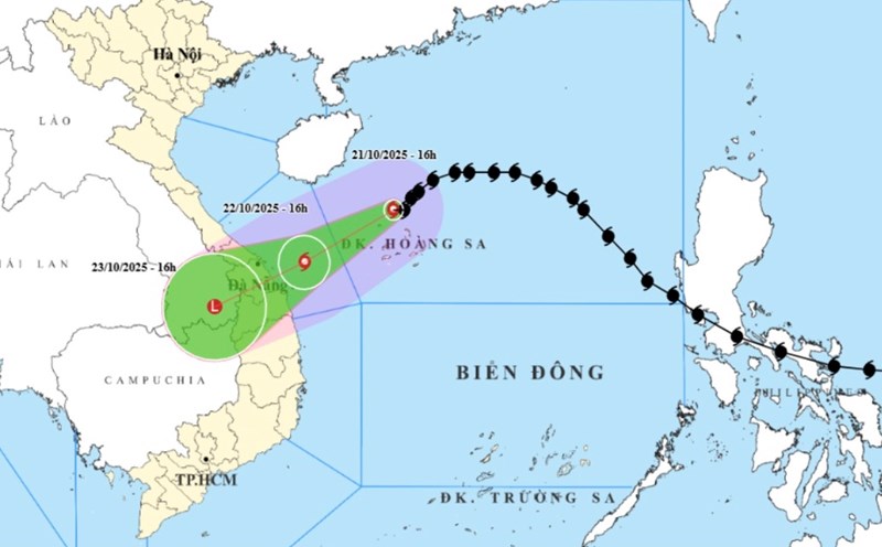
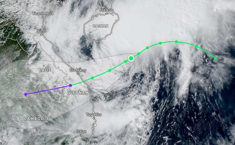
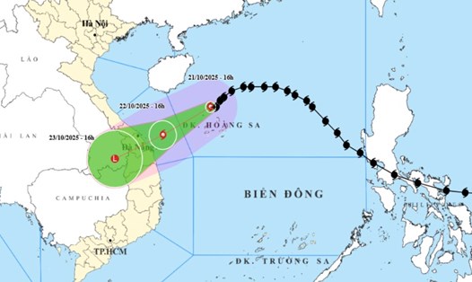
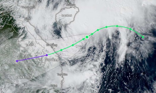
According to the latest weather forecast from the National Center for Hydro-Meteorological Forecasting, storm No. 12 Fengshen is still more than 300km from Da Nang City, to the East Northeast.
The strongest wind near the storm center is level 9-10 (75-102km/h), gusting to level 12. The storm is moving in a West-Southwest direction at a speed of 10-15km/h.
It is forecasted that by the evening of October 22, the storm will continue to move in the West Southwest direction at a speed of 10-15km/h, in the sea area along Hue City to Quang Ngai.
At this time, the storm will gradually weaken, the intensity will decrease to level 8, gusting to level 10.
However, the western sea area of the North East Sea (including Hoang Sa special zone), the sea area from Quang Tri to Quang Ngai (including Con Co special zone, Cu Lao Cham island and Ly Son special zone) still face a level 3 natural disaster risk.
The sea area from Quang Tri to Quang Ngai (including Con Co special area, Cu Lao Cham island and Ly Son special area) will have strong winds of level 6, from early morning on October 22 increasing to level 7, the area near the storm's eye will have level 8, gusts of level 10, waves 3.0-5.0m high, rough seas.
The coastal areas of the provinces from Quang Tri to Da Nang will have storm surge of 0.3-0.5m high.
Due to the influence of storm No. 12 combined with strong cold air, from the afternoon of October 22, the weather forecast on the mainland along the coast of the provinces from Quang Tri to Da Nang will gradually increase to level 6, sometimes level 7, gusting to level 8-9.
From noon on October 22 to October 27, the area from Ha Tinh to Quang Ngai is likely to have widespread heavy rain (high intensity rain will be concentrated from the afternoon of October 22 to the end of October 23).
Total rainfall is generally in: Ha Tinh to Bac Quang Tri and Quang Ngai about 200-400mm, locally over 500mm; from South Quang Tri to Da Nang City, it is generally 500-700mm, locally over 900mm. Warning of heavy rain (over 200mm/3 hours).
Heavy rain in the Central region is likely to last until the end of October 2025.
People and tourists should be on guard against high risk of flash floods and landslides in mountainous areas, flooding in low-lying areas and urban areas.
Localities need to pay attention to safe operation of hydroelectric and irrigation reservoirs before, during and after the storm, and prepare response plans for flood scenarios on rivers from Quang Tri to Quang Ngai that are likely to reach alert level 3 and exceed alert level 3. Forecast of natural disaster risk level due to floods: level 3.

Weather forecast for tomorrow, October 22, nationwide:
Hanoi
Lowest temperature: 20-22 degrees Celsius.
Highest temperature: 25-27 degrees Celsius.
Cloudy, some rain at night, sunny during the day. Northeast wind level 3.
Northwest
Lowest temperature: 18-21 degrees Celsius, some places below 16 degrees Celsius.
Highest temperature: 25-28 degrees Celsius.
Cloudy, some rain at night, sunny during the day. Light wind. Cold at night and morning, some places are cold.
Northeast
Lowest temperature: 18-21 degrees Celsius, mountainous areas 16-18 degrees Celsius, high mountainous areas below 16 degrees Celsius.
Highest temperature: 24-27 degrees Celsius.
Cloudy, some rain at night, sunny during the day. Northeast wind level 3, especially coastal areas level 4, some places level 5. Cold at night and morning, some mountainous areas are cold.
Thanh Hoa to Hue
Lowest temperature: 22-25 degrees Celsius.
Highest temperature: 24-27 degrees Celsius.
The North is cloudy, with rain at night and sunny days. The South (from Ha Tinh to Hue City) is cloudy, with scattered showers and thunderstorms at night and in the morning, with some places having heavy rain; from tomorrow afternoon there will be moderate rain, heavy rain and thunderstorms, with some places having very heavy rain, especially in South Quang Tri and Hue City.
North to northwest wind level 3, coastal areas level 4, some places level2; from tomorrow afternoon coastal areas from Quang Tri to Hue City, the wind will gradually increase to level 6, sometimes level 7, gusting to level 8-9. During thunderstorms, there is a possibility of tornadoes, lightning and strong gusts of wind.
South Central Coast
Lowest temperature: 23-26 degrees Celsius.
Highest temperature: North 27-29 degrees Celsius, South 30-33 degrees Celsius.
Cloudy, scattered showers and thunderstorms, locally heavy rain; in the North from tomorrow afternoon there will be moderate rain, heavy rain and thunderstorms, locally very heavy rain, especially in Da Nang City there will be heavy to very heavy rain.
North north to northwest wind level 3, from tomorrow afternoon on the coast of Da Nang City, the wind will gradually increase to level 6, sometimes level 7, gusting to level 8-9; South north to northeast wind level 2-3. During thunderstorms, there is a possibility of tornadoes, lightning and strong gusts of wind.
Central Highlands
Lowest temperature: 19-22 degrees Celsius.
Highest temperature: 27-30 degrees Celsius.
Cloudy, with showers and thunderstorms in some places; in the afternoon and evening, there will be scattered showers and thunderstorms, with some places having heavy rain. Light wind. During thunderstorms, there is a possibility of tornadoes, lightning, hail and strong gusts of wind.
Southern region
Lowest temperature: 23-26 degrees Celsius.
Highest temperature: 31-34 degrees Celsius.
Cloudy, with showers and thunderstorms in some places; in the afternoon and evening, there will be scattered showers and thunderstorms, with some places having heavy rain. Light wind. During thunderstorms, there is a possibility of tornadoes, lightning, hail and strong gusts of wind.
Ho Chi Minh City
Lowest temperature: 24-26 degrees Celsius.
Highest temperature: 32-34 degrees Celsius.
Cloudy, with showers and thunderstorms in some places; in the afternoon and evening, there will be scattered showers and thunderstorms, with some places having heavy rain. Light wind. During thunderstorms, there is a possibility of tornadoes, lightning, hail and strong gusts of wind.