
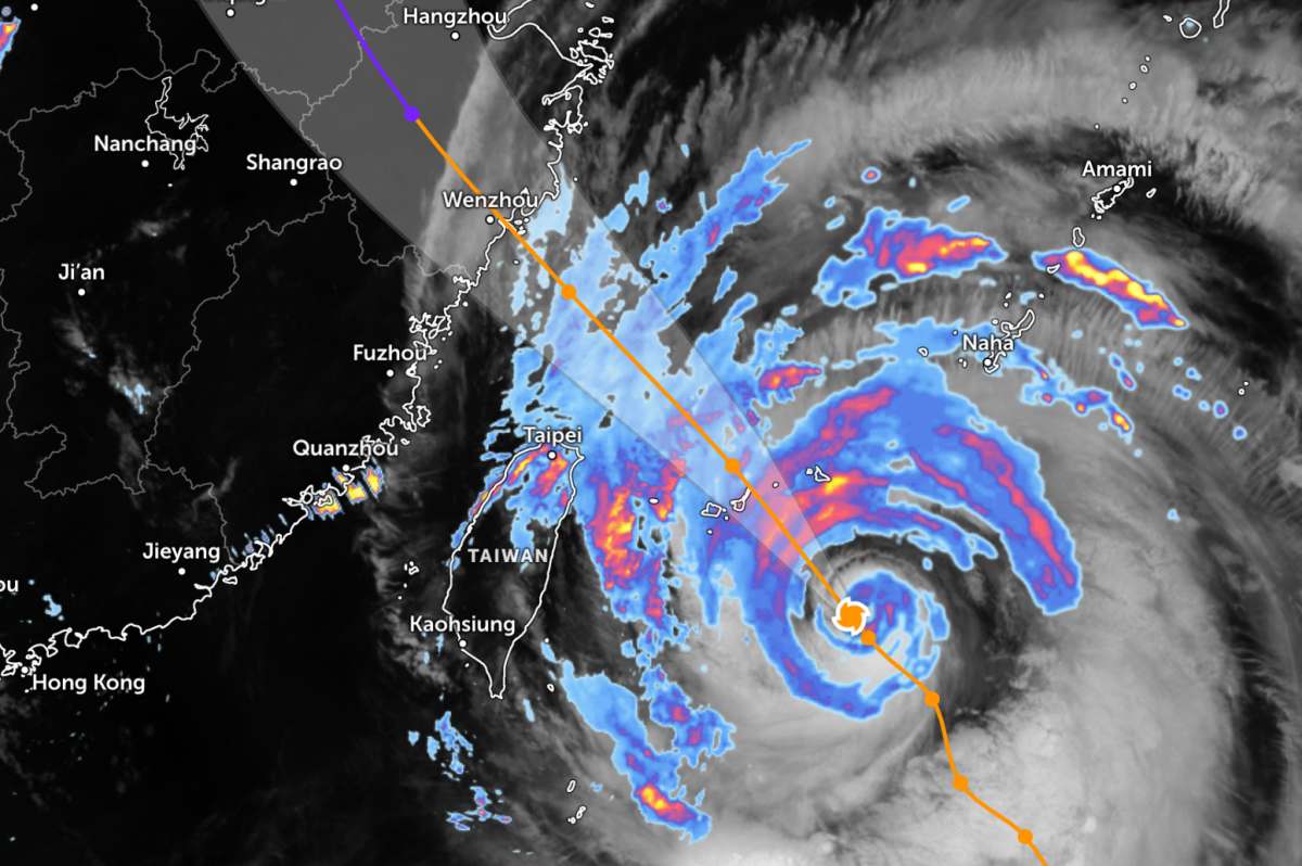
According to satellite observations, the circulation of super typhoon Ba Vi is about 940,000 km2 wide, with a diameter of nearly 1,000 km. The National Meteorological Center of China forecasts that the typhoon will approach the northern area of Taiwan (China) before making landfall in Fujian province on July 11.
The Taiwan (China) meteorological agency said that storms of the scale of Super Typhoon Ba Vi have become rare in recent years. Mr. Jason Chang, a weather forecaster at this agency, said that Super Typhoon Ba Vi may be the largest storm to affect the island since 1987.
Local authorities warned that mountainous areas in the North Taipei area could receive up to 1,000 mm of rainfall. About 29,000 soldiers have been put on duty.
In Suao port town, many fishing boats have entered anchorages to avoid the storm. People are urgently preparing sandbags to protect their homes, while farmers are speeding up rice harvesting before the weather worsens.
In Japan, the country's Meteorological Agency said that Super Typhoon Ba Vi will move near the Sakishima Islands in Okinawa Prefecture from July 10-11 and will still maintain very strong intensity.
According to forecasts, gusts could reach 180 km/h on July 10 and increase to 252 km/h on July 11, a level strong enough to cause serious damage to construction sites.
The Sakishima archipelago area is forecast to have rain with intensity up to 50 mm/hour. From noon on July 10 to noon on July 11, total rainfall in some places may reach 300 mm. Authorities also warned of sea waves over 10 m high and the risk of storm surge causing coastal flooding.
Aviation operations in the region have begun to be affected as the storm approaches. Japan Airlines canceled 48 domestic flights and 2 international flights on July 10, affecting about 7,610 passengers.
All Nippon Airways also canceled 34 flights to and from Okinawa, affecting about 1,800 passengers, and announced that it will continue to cancel 33 more domestic flights on July 11.
In China, the National Meteorological Center has raised the storm warning to orange - the second highest level of warning in the country. People in many eastern provinces have been recorded to have stockpiled necessities and reinforced their houses to minimize damage caused by the storm.
Taiwan's (China) largest international airport has also canceled all flights scheduled for operation on July 11 due to the impact of Super Typhoon Ba Vi.
People and tourists who plan to go to areas affected by the storm should closely monitor weather developments. Regularly check flight schedules and follow local instructions to avoid dangerous storms.


