According to storm news, the latest low pressure from the Joint Typhoon Warning Center (JTWC), Typhoon Narelle has strengthened to super typhoon level in the Indian Ocean.
The center of Super Typhoon Narelle is currently about 217 km north-northeast of Learmonth (Australia). In the past 6 hours, the super typhoon has moved in a Southwest direction at a speed of 20 km/h. The highest wave height reached about 11.6 m.
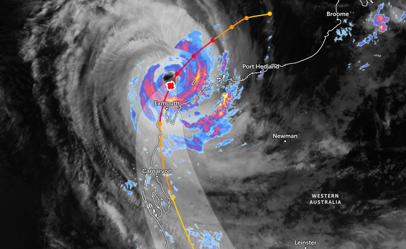
It is forecasted that in the next 12 hours, the super typhoon will go around the edge of the subtropical high pressure, then change direction to move southward and gradually slope south-southeast within 24 hours.
After 24 hours, Narelle will accelerate when going deep inland, in the eastern area of the cities of Geraldton and Perth, before returning to the southern West Australian sea area after about 2 days.
According to the Australian Bureau of Meteorology (BOM), Super Typhoon Narelle is likely to reach level 5 in a short time before weakening and making landfall, expected on Friday night near Shark Bay. The main impacts are forecast to include strong winds, widespread heavy rain and dangerous high waves, especially in the Exmouth area.
Faced with the complicated developments of the storm, many schools have closed, mine workers have been given leave, while people are urgently reinforcing their houses with sandbags. In areas like Karratha, strong winds have knocked down trees and caused initial damage as the storm intensifies offshore.
Warning that strong winds could spread, causing serious damage to houses and works. Authorities said that areas on the storm's path need to prepare to withstand winds up to 200 km/h, and advised people living in substandard houses to go to safe shelters.
Forecast for the evening of March 26, areas such as Exmouth and Onslow may experience gusts of up to 275 km/h. Heavy rain will also appear over a wide area, with rainfall from 100-200 mm at Coral Bay and Exmouth, while Perth may record 40-60 mm. On March 28, rain will continue to be maintained in many areas with common rainfall of 20-50 mm.
According to meteorologists, Hurricane Narelle formed from the Coral Sea off the east coast of Australia, which caused floods in Northern Territory before weakening. However, this system has strengthened again as it moves off the coast of Kimberley and continues to head south, directly threatening the coastal area of Western Australia in the coming days.
People and tourists planning to visit Shark Bay or near the storm's path should pay attention to weather forecasts. Check flight schedules and follow local instructions to ensure safety.


