According to the National Center for Hydro-Meteorological Forecasting, on the morning of September 23, super typhoon Ragasa (typhoon No. 9) continued to move deep into the East Sea.
At 7:00 a.m., the center of the storm was at about 19.9 degrees North latitude - 118.3 degrees East longitude, about 860km east of the Lusi Peninsula (China). The strongest wind near the center of the super typhoon is level 17 (202-221km/h), gusting over level 17.
It is forecasted that in the next 3 hours, the storm will move in a West-Northwest direction, at a speed of about 20km/h.
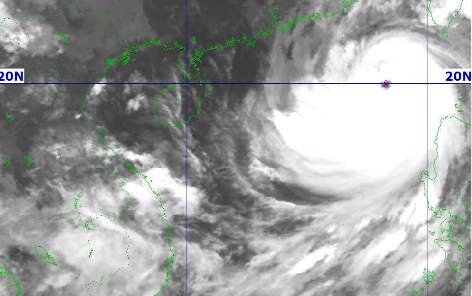
It is forecasted that by 4:00 a.m. on September 24, the center of the super typhoon will be at about 21.1 degrees North latitude - 114.5 degrees East longitude, in the northern sea area of the North East Sea, about 450km east of the Lusian Peninsula (China). The strongest wind near the storm center is level 16-17, gusting over level 17.
The storm is moving west-northwest at a speed of 20 - 25 km/h. Natural disaster risk level: level 4 in the northern sea area of the North East Sea.
At 4:00 a.m. on September 25, the center of the super typhoon was at about 21.5 degrees North latitude - 109.6 degrees East longitude, in the mainland south of Guangzhou Province (China). The strongest wind near the storm center is level 12, gusting to level 15.
The super typhoon is moving west-northwest at a speed of 20-25 km/h and gradually weakening. Disaster risk warning level: level 4 for the northern sea area of the North East Sea, level 3 for the northern Gulf of Tonkin.
At 4:00 a.m. on September 26, the center of storm No. 9 was at about 20.8 degrees North latitude - 105.1 degrees East longitude, in the Northern region. The strongest wind near the center will decrease to level 6, gusting to level 8.
The storm is moving in a West-Southwest direction at a speed of 20 - 25 km/h and continues to weaken into a tropical depression. Disaster risk warning level: level 3 in the northwestern sea area of the North East Sea and the Gulf of Tonkin.
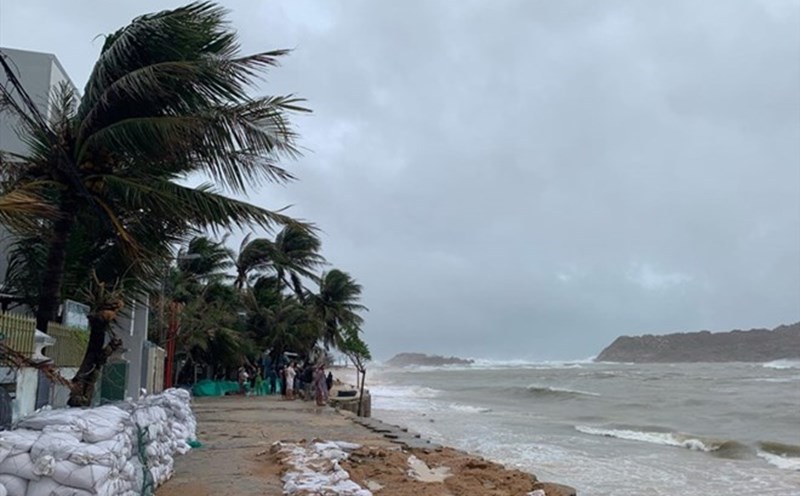
Due to the influence of super typhoon Ragasa, the sea area north of the North East Sea will have strong winds of level 8-9, then increase to level 10-14, the area near the center of the super typhoon will have winds of level 15-17, gusts above level 17, waves over 10.0m high; the sea will be very rough.
From September 24, the eastern sea area of the Gulf of Tonkin (including Bach Long Vy island district) will have winds gradually increasing to level 6-7, gusting to level 9. From the evening and night of September 24, the Gulf of Tonkin (including Bach Long Vy, Van Don, Co To, Cat Hai and Hon Dau island) will have winds gradually increasing to level 8-9, waves 2.0-4.0m high, the area near the storm's eye will have winds of level 10-12, gusting to level 14. Waves are 4.0-6.0m high, rough seas.
The coastal areas of Quang Ninh-Hai Phong provinces will have storm surge of 0.5-1.0m high. High risk of landslides, sea embankments, destruction of aquaculture areas, ships and boats anchored along the coast due to strong winds, rising sea levels and big waves.
On land, from early morning on September 25, coastal areas from Quang Ninh to Thanh Hoa will have winds gradually increasing to level 6-7, then increasing to level 8, near the storm center level 9-10, gusting to level 12. The deep inland area of the Northeast will have strong winds of level 6-7, gusting to level 8-9.
From the night of September 24 to September 26, in the Northern region, Thanh Hoa and Nghe An, there will be heavy to very heavy rain with common rainfall of 100-250mm, locally over 400mm. Beware of heavy rain causing urban flooding.
Heavy rain is likely to cause flooding in low-lying areas; flash floods on small rivers and streams, landslides on steep slopes. Due to the influence of a wide storm circulation, it is necessary to be on guard against the risk of thunderstorms, tornadoes and strong gusts of wind both before and during the storm's landfall.
People and tourists should consider going out when the weather is harsh. Monitor weather forecasts and follow local instructions to avoid dangerous storms.