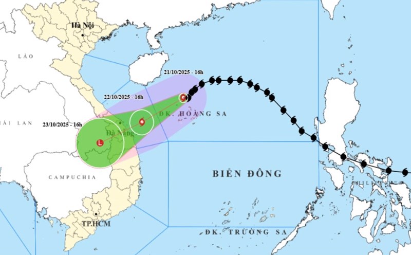
According to the National Center for Hydro-Meteorological Forecasting, at 1:00 p.m. on October 21, the center of storm No. 12 Fengshen was at about 17.5 degrees North latitude - 112.2 degrees East longitude, in the sea north of the Hoang Sa archipelago, about 450km east-northeast of Da Nang.
The strongest wind near the storm center is level 910 (75102 km/h), gusting to level 12. The storm is moving southwest at a speed of 1015 km/h.
It is forecasted that by 1:00 p.m. on October 22, the storm will move in a West-Southwest direction at a speed of 10.15 km/h. The center of the storm is located at about 16.2 degrees North latitude - 109.6 degrees East longitude, about 145km East Northeast of Da Nang.
Strong wind level 8, gust level 10, gradually weakening. Natural disaster risk level: Level 3 for the western sea area of the North East Sea, including Hoang Sa; the sea area from South Quang Tri to Quang Ngai.
At 1:00 p.m. on October 23, the storm continued to move in a West-Southwest direction at a speed of 10.15 km/h, moving inland from Quang Tri to Da Nang.
After that, Typhoon Fengshen gradually weakened into a tropical depression and then a low pressure area in the Southern Laos area. Wind power below level 6. Natural disaster risk level: Level 3 for the sea area from South Quang Tri to Quang Ngai, including Con Co, Cu Lao Cham, Ly Son; coastal mainland of the provinces from Quang Tri to Da Nang.
Due to the influence of storm No. 12, the northwestern sea area of the East Sea (including Hoang Sa archipelago) has strong winds of level 78, near the storm center level 910, gusting to level 12. Waves are 35m high, near the center of the storm are 57m, the sea is very rough.
The sea area from Quang Tri to Quang Ngai (including Con Co, Cu Lao Cham, Ly Son) has strong winds of level 6. From the morning of October 22, it increased to level 7, near the storm center level 8, gusting to level 10. Waves are 35m high, rough seas. Coastal water from Quang Tri to Da Nang may rise by 0.30.5m.
All ships in the danger zone are at high risk of being affected by thunderstorms, whirlwinds, strong winds and large waves. The coastal areas from Quang Tri to Da Nang need to be on guard against big waves combined with high tides and rising water causing flooding in low-lying areas and coastal erosion.
On land, from the afternoon of October 22, coastal provinces from Quang Tri to Da Nang will have winds gradually increasing to level 6, sometimes level 7, gusting to level 89.
Due to the influence of the circulation of storm No. 12 combining cold air and East wind, terrain effects, from noon on October 22 to October 27, the area from Ha Tinh to Quang Ngai will have heavy to very heavy rain, concentrated most strongly from the afternoon of October 22 to the end of October 23.
The areas of Ha Tinh - Bac Quang Tri and Quang Ngai will have rainfall of 200400mm, some places over 500mm. The South Quang Tri - Da Nang area will have rainfall of 500700mm, some places over 900mm. Warning of very heavy rain (>200mm/3 hours).
Heavy rain in the Central region is likely to last until the end of October 2025. There is a very high risk of flash floods, landslides in mountainous areas; flooding in low-lying, low-lying areas and urban areas.
Localities need to proactively operate hydropower and irrigation reservoirs safely; prepare response plans when the river water level from Quang Tri to Quang Ngai is likely to reach or exceed alert level 3. Flood risk level: Level 3.
Beware of the risk of thunderstorms, tornadoes, strong gusts of wind in the area affected by the storm's circulation, both before and during the storm's landfall.
People and tourists planning to visit areas where storms pass through or are affected by storm circulation should pay attention to weather forecasts. Check your flight schedule regularly and avoid going outside during heavy rain and strong winds to ensure safety.