Revolutionary poet To Huu praised the forests that know how to "guard the army and surround the enemy" in the Northwest and Northwest, but he also praised the steadfast and steadfast qualities at the top of the Nam Can mangrove forest in the heroic song "T Three hundred years of our Party":
"The steppe has grown into a hardwood forest
The more the wind shakes, the more it strengthens...
That is a beautiful and very accurate image of the mangrove forest during the period of resistance war against invaders and gaining our independence and freedom. In this remote land for those who travel to open the land, not afraid to "go on the sacred land, under the fierce crocodile river", the spirit of patriotism is as strong as a natural thing.
Therefore, the vast mangrove forests in Nam Can have soon appeared in the heroic historical era of the resistance wars against foreign invaders that took place in a long time. The mangrove forest has become a solid foundation for sheltering officers and soldiers working in Dat Mui.
The steppe, fish sauce, bamboo shoots, and cajuput are the natural walls of the revolution with dense forests, layered with classes, blocking the means of "catching the eyes" of the enemy. The overlapping structure and the diversity and complexity of canals and rivers have caused mangrove forests to not only cause difficulties for the enemy but also break many enemy campaigns.
Under the mangrove forest canopy, the resistance areas were established and named "Ca Mau forest village". Here, mangrove forests became an important place to hide troops and a revolutionary base, implementing notorious campaign tactics such as "taking advantage of free energy, fighting for fatigue" or "using land to fight against the power of weapons"...
The resilient and indomitable mangrove forests of Nam Can have therefore been included in the literature in the short story Ca Mau Mangrove by writer Doan Gioi: The mangrove trees are tall, with firm roots from the middle of the trunk, like arms sticking to the ground. For example, the people of the South have always clinged to the land, fought tirelessly before and during the ten years of resistance to carry out peace, unify the country, complete independence and democracy for the Fatherland".
With the advantage of the sea, forests and a system of river banks, canals, and mangrove forests, Ca Mau has been chosen as the final and largest gathering point for the legendary transport route, the "Ho Chi Minh Trail at Sea" of the Vietnam People's Navy and the Southern Liberation Army, the artery carrying weapons, equipment and officers from the North to the Southern battlefield.
The path of this willpower is the journey of unnumbered ships carrying weapons from Hon Dau (Hai Phong) to Vam Lung (Ca Mau), overcoming thousands of dangers, life and death and the system of modern, advanced and dense reconnaissance, monitoring and sabotage by the enemy for the goal of "fighting the river in one strip".
These days, Ca Mau mangrove forest is reviewing a memorable historical milestone of the "Ho Chi Minh Trail at Sea". Vam Lung Wharf (now in Phan Ngoc Hien Commune) safely welcomed the first unnumbered ship on October 16, 1962, commanded by Captain Le Van Mot and economist Bong Van Dia.
This is the first ship of the historic journey of the "Unnumbered Ship sufferings" across the East Sea, bringing weapons from the North to the South. From that time until the day the South was completely liberated (April 30, 1975), Vam Lung wharf received 68 ships with more than 4,400 tons of weapons, armored goods, and military equipment. Then came Vam Lung, Nam Can, U Minh, which became the bright red addresses of the legend of "Ho Chi Minh Trail at Sea".
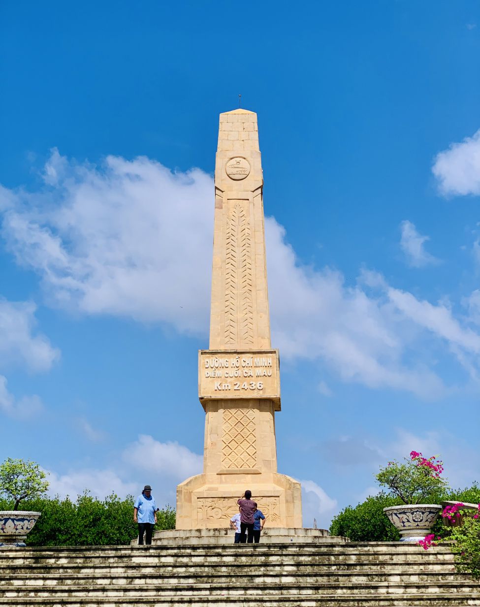
Also in the grounds of Ca Mau Cape National Park, a monument - relief area was erected to mark the end of the Ho Chi Minh road. This place places the sacred milestone of kilometre 2436. At this milestone, the Ho Chi Minh trail of the "cutting along Truong Son to save the country" resistance war against the US officially ended.
The route started from km 0 in Pac Bo - Cao Bang, crossed 28 provinces and ended at the Southernmost point. This project was built in 2017, a year after the road connecting Ca Mau city with Dat Mui commune was completed. Thus, this is also the end point of National Highway 1A, turning Dat Mui into the final gathering point of the nature roads.
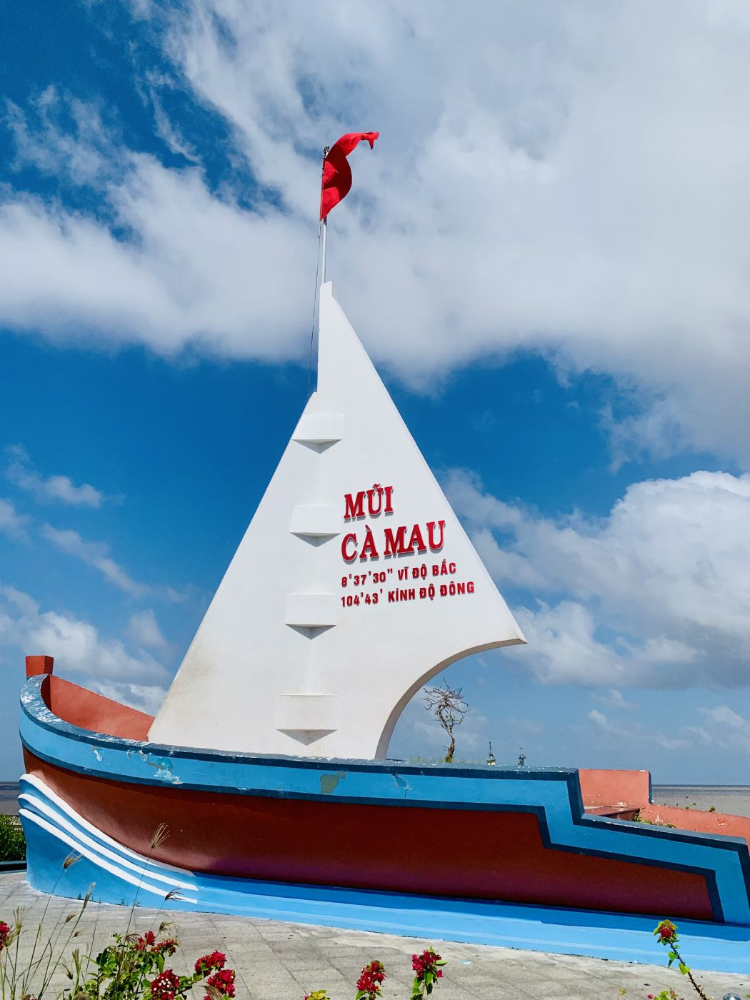
Not only that, this area is also the place to mark the southernmost point of Vietnam. Previously, the national coordinate landmark GPS 0001 was located in a remote location, in Mui Bai Bung, Phan Ngoc Hien commune. From this cape, looking out to the East Sea, you will see the famous Hon Khoai island that has appeared in works about the journeys to escape Con Dao prison.
Hon Khoai Island is also associated with revolutionary soldier Phan Ngoc Hien, who led the uprising that broke out on Hon Khoai Island under the direction of the Bac Lieu Provincial Party Committee in 1940. The name of the hero in the past has become the name of the country and homeland.
Up to now, in addition to the National Coefficient GPS 0001, the southernmost point is also positioned at coordinates 104o43 East longitude, 8o3430 North latitude and is symbolized by the image of the bow of a ship with a white sails carrying the Vietnamese flag pointed across the sea.
Obviously, in addition to the value of nature, landscape, environment, economy and culture, the mangrove forests of Mui Ca Mau National Park also have great historical value. That value lives on in poems and memorabilia, as well as in the minds of the Vietnamese people.