According to the latest information from the Philippine Atmospheric, Geophysical and Astronomical Services Administration (PAGASA), the tropical depression outside the forecast area (PAR) has strengthened into storm Bebinca since the night of September 10.
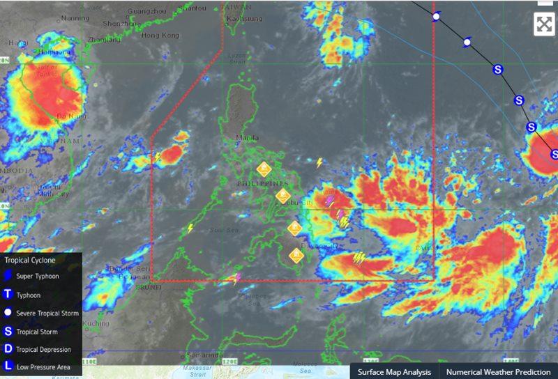
As of 10:00 a.m. on September 11 (local time), the center of Bebinca was estimated to be at approximately 14.0 degrees north latitude, 142.3 degrees east longitude, 1,825 km east-northeast of Eastern Visayas, and 1,955 km east-southeast of Luzon. Winds near the center of the storm were at a maximum of 85 km/h, gusting up to 105 km/h, and the central pressure was 992 hPa. The wind range was 480 km from the center of the storm.
Tropical Storm Bebinca formed on September 10 near the US territory of Guam in the western Pacific Ocean and is expected to strengthen as it moves northwest.
PAGASA's typhoon forecast said Bebinca is expected to move mainly northwestward until the evening of September 13, then turn west-northwestward. The storm is expected to enter the PAR region of the Philippines on September 14.
Bebinca is expected to strengthen into a severe tropical storm in the next 24 hours and could reach typhoon strength by the afternoon of September 12.
Bebinca is not expected to directly impact the Philippine mainland. However, the storm is expected to intensify the southwest monsoon, bringing rains in the Visayas and Palawan, and thunderstorms in Bicol and Mindanao from September 12 onwards.
In the face of this storm, countries around the East Sea continue to be affected. Tourists wishing to travel to the Philippines or other countries in the region should monitor the weather before their trip, ensure their schedule is not delayed and be on the lookout for danger.