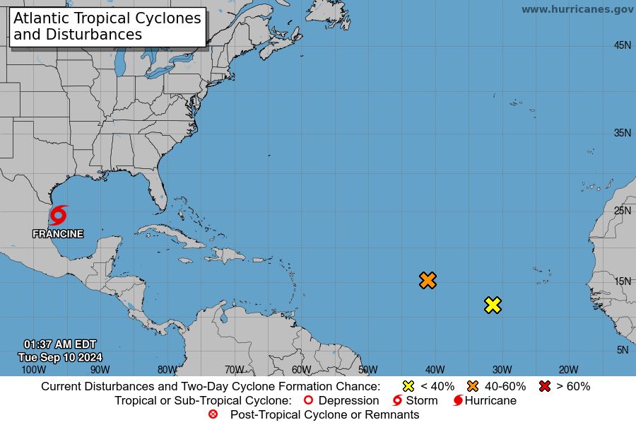
The US National Hurricane Center (NHC) has just issued Intermediate Warning Bulletin No. 6A on Tropical Storm Francine.
Hurricane Francine is being tracked at 24.3 degrees North and 96.3 degrees West, approximately 125 miles (205 km) southeast of the Rio Grande and approximately 430 miles (690 km) south-northwest of Cameron, Louisiana.
Maximum sustained winds near the center of the storm are currently around 100 km/h with higher gusts. The storm is moving northwest at 7 km/h and the lowest central pressure measured is 992 mb.
There are currently no changes to previous warnings and advisories. A storm surge warning is in effect from High Island, Texas, to the mouth of the Mississippi River, Louisiana, along with Vermilion Bay.
A hurricane warning has also been issued for the Louisiana coast from Sabine Pass to Morgan City. A tropical storm warning is in effect from Morgan City to Grand Isle, including High Island to Sabine Pass, the mouth of the Rio Grande to Port Mansfield, and La Pesca Mexico to the mouth of the Rio Grande.
A storm surge warning means there is a life-threatening risk from rising water moving inland within the next 36 hours.
The NHC advises residents to be on high alert for life-threatening flooding from rising water over the next 48 hours.
Residents and visitors in the area are advised to take necessary precautions to protect themselves from high water warnings and other dangerous conditions.
Tropical Storm Francine is currently moving slowly north-northwest at 7 km/h and is expected to continue in this direction today, before turning northeast at an increasing speed.
Forecasts show the storm likely making landfall in Louisiana on September 11. The storm’s current maximum sustained winds are around 60 mph (100 km/h), with higher gusts. Francine is likely to become a tropical storm today, with the potential to strengthen before making landfall.
The storm's strong winds are now extending as far as 220 km from the center. The lowest central pressure is estimated at 992 mb as observed from the Hunter aircraft.
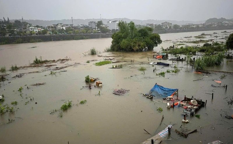
In terms of rainfall, Francine is expected to bring total rainfall amounts of 100 to 200 mm, with some areas receiving up to 300 mm. This rainfall could cause severe and flash flooding in affected areas.
Dangerous surf and high water levels may cause flooding in coastal areas near the shore. High water levels could reach 1 to 3 m in some areas, with peak levels predicted to be 1.5 to 3 m along the coast near landfall.
Given the above situation, tourists planning to visit the above areas should pay attention to weather updates and consider postponing their trips to ensure safety.