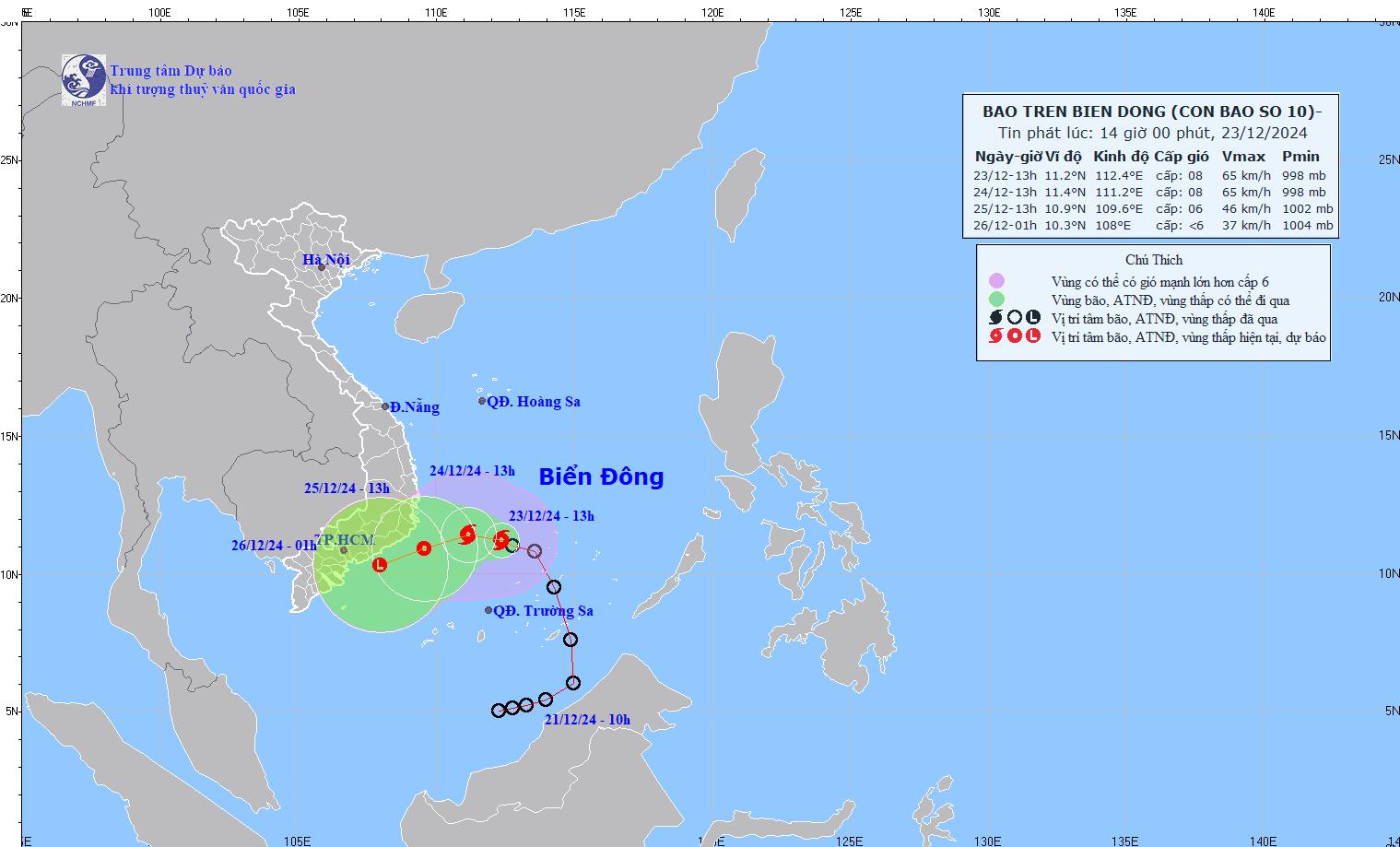
According to the latest storm information from the National Center for Hydro-Meteorological Forecasting, at 4:00 p.m. on December 23, the center of storm No. 10 was located at approximately 11.3 degrees North latitude - 112.4 degrees East longitude, in the area northwest of Truong Sa archipelago.
The strongest wind near the storm center is level 8 (62-74km/h), gusting to level 10. The storm moves in a West Northwest direction, at a speed of 5-10km/h.
Forecast until 4pm on December 24, the storm is moving west, speed 5-10km/h. The center of the storm is located at about 11.3 degrees North latitude - 111.1 degrees East longitude, in the southwest sea area of the Central East Sea.

The strongest wind near the storm center is level 8, gusting to level 10. Disaster risk level: level 3 for the Northwest of the South China Sea (including the Northwest of Truong Sa archipelago), the Southwest of the Central China Sea.
At 4:00 p.m. on December 25, the storm moved west-southwest at a speed of about 5-10 km/h and gradually weakened into a tropical depression. The center of the tropical depression was located at about 10.8 degrees North latitude - 109.5 degrees East longitude, over the sea from Phu Yen to Ba Ria-Vung Tau.
The strongest wind intensity near the storm center is level 6, gusting to level 8. Disaster risk level: level 3 for the sea area from Phu Yen to Ba Ria - Vung Tau, the sea area southwest of the Central East Sea, the sea area northwest of the South East Sea (including the area northwest of Truong Sa archipelago).
It is forecasted that at around 4am on December 26, the low pressure will move in a West-Southwest direction at a speed of 10-15 km/h and gradually weaken into a low pressure area. The center of the low pressure will be located at around 10.2 degrees North latitude - 107.8 degrees East longitude, over the sea from Binh Thuan to Tra Vinh. The strongest wind intensity is below level 6.
Due to the influence of storm No. 10, the northwest sea area of the South East Sea (including the northwest sea area of Truong Sa archipelago) and the southwest sea area of the Central East Sea have strong winds of level 6-7, the area near the storm center has strong winds of level 8, gusts of level 10, waves 4.0-6.0m high. Rough seas.
The sea area from Phu Yen to Ba Ria-Vung Tau (including Phu Quy island) has strong winds of level 6, sometimes level 7, gusting to level 8-9, waves 3.0-6.0m high. Rough seas.
Residents and tourists in localities forecasted to be affected by the storm from Phu Yen to Ba Ria - Vung Tau need to pay attention to weather forecasts, updated flight schedules, transportation units... to be proactive about their schedules and prepare safety measures.


