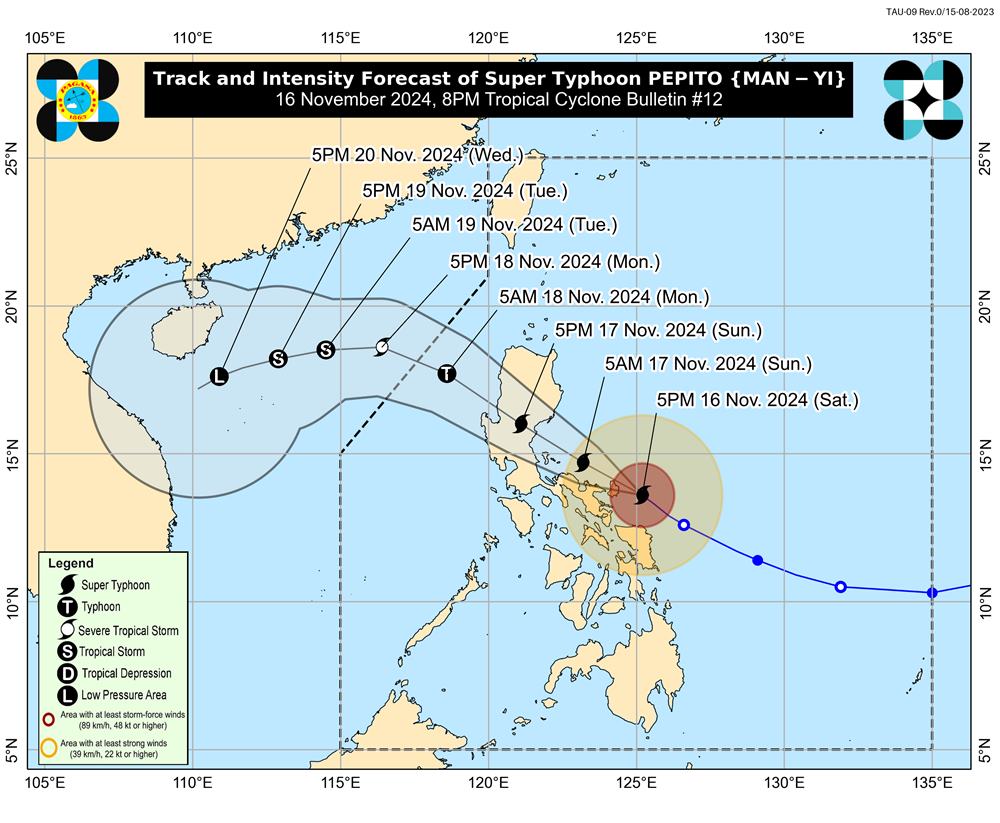
According to the latest weather forecast from the National Center for Hydro-Meteorological Forecasting, at 7:00 p.m. on November 16, the center of super typhoon Man-yi was located at about 13.9 degrees North latitude - 124.6 degrees East longitude, in the sea east of the central Philippines. The strongest wind near the center of the super typhoon is level 16 (184-201 km/h), gusting to level 17 (240 km/h). The storm is moving northwest at a speed of 20 km/h.
It is forecasted that by 7:00 p.m. on November 17, super typhoon Man-yi will continue to move northwest at a speed of about 20 km/h. The center of the storm is located at about 16.2 degrees North latitude - 121.0 degrees East longitude, on Luzon Island (Philippines). The strongest wind near the center of the storm is level 14, gusting to level 16. Natural disaster risk level: level 3 for the eastern part of the North East Sea.

At 7:00 p.m. on November 18, the storm was still moving northwest, accelerating to 20-25 km/h, entering the East Sea and gradually weakening. The center of the storm was located at about 18.3 degrees North latitude - 116.7 degrees East longitude, in the sea area east of the North East Sea, about 600 km east-northeast of Hoang Sa archipelago. The strongest wind near the center of the storm was level 12, gusting to level 14. Natural disaster risk level: level 3 for the east of the North East Sea.
At 7:00 p.m. on November 19, Typhoon Man-yi moved in a West-Northwest direction at a speed of about 15 km/h. The center of the storm was located at about 18.9 degrees North latitude - 113.2 degrees East longitude, in the North East Sea, about 330 km North-Northeast of Hoang Sa archipelago. The strongest wind near the center of the storm was level 9, gusting to level 11. Natural disaster risk level: level 3 for the North East Sea.
Warning in the next 72 to 120 hours, the storm will move southwest, 10km per hour, and continue to weaken.
Under the influence of the storm, from the afternoon of November 17, the sea area east of the North East Sea has strong winds of level 6-7, then increasing to level 8-9, the area near the storm's eye has winds of level 10-12, gusts of level 16, waves 2.0-4.0m high, the area near the storm's eye has waves of 5.0-7.0m. The sea is very rough.
With the current weather conditions, tourists who want to travel to the Philippines at this time should monitor weather forecasts and check announcements from airlines and travel agencies to proactively plan their schedules.


