Latest update from the National Center for Hydro-Meteorological Forecasting, at 7:00 a.m. on September 27, the center of the storm was at about 14.1 degrees north latitude; 115.8 degrees east longitude, about 480 km east-southeast of Hoang Sa Special Zone. The strongest wind near the storm center is level 11-12 (103-133 km/h), gusting to level 15. The storm is moving west-northwest at a speed of about 35 km/h.
Storm No. 10 will strengthen to level 16 in the next 24 hours
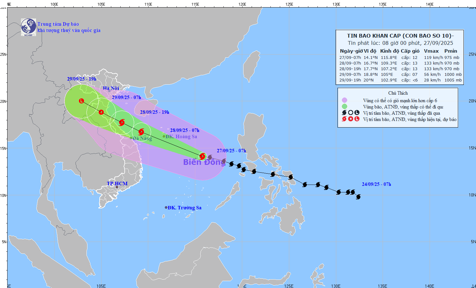
It is forecasted that in the next 24 hours, the storm will move west-northwest at a speed of 30-35 km/h and is likely to strengthen. At 7:00 a.m. on September 28, the center of the storm was at about 16.7 degrees north latitude; 109.3 degrees east longitude, in the southern sea of Quang Tri - Quang Ngai, about 130 km east-northeast of Da Nang. Strong storm intensity level 12-13, gust level 16.
The danger zone is from latitude 12 degrees north to 19 degrees north, west of longitude 119 degrees east. Level 3 natural disaster risk for the northern and central East Sea (including Hoang Sa special zone) and the sea area from Ha Tinh to Quang Ngai.
It is forecasted that in the next 36 hours, the storm will move west-northwest at a speed of 20-25 km/h. At 7:00 p.m. on September 28, the center of the storm was at about 17.7 degrees north latitude; 107.2 degrees east longitude, in the sea from Nghe An to Hue City. Strong storm intensity level 12-13, gust level 16.
The danger zone is north of latitude 14 degrees north, west of longitude 112.5 degrees east. Level 3 natural disaster risk for the western sea area of the northern East Sea (including Hoang Sa special zone), northwest of the central East Sea area, from Thanh Hoa to Quang Ngai (including Hon Ngu island, Con Co and Ly Son special zone) and the northern Gulf of Tonkin (including Bach Long Vi, Van Don, Co To, Cat Hai and Hon Dau island special zone), the area from Ninh Binh to Hue city.
It is forecasted that in the next 48 hours, the storm will move west-northwest at a speed of 20-25 km/h and weaken into a tropical depression. At 7:00 a.m. on September 29, the center of the storm was at about 18.8 degrees north latitude; 105.0 degrees east longitude, on the mainland of Nghe An - Ha Tinh. Strong intensity level 8, gust level 10.
The danger zone is north of latitude 15 degrees north, west of longitude 110.5 degrees east. Level 3 natural disaster risk for the western sea area of the northern East Sea (including Hoang Sa special zone), from Thanh Hoa to Quang Ngai (including Hon Ngu island, Con Co and Ly Son special zone) and the northern Gulf of Tonkin (including Bach Long Vi, Van Don, Co To, Cat Hai special zone and Hon Dau island), the area from Ninh Binh to Hue city.
It is forecasted that in the next 60 hours, the tropical depression will continue to move west-northwest at a speed of 20-25 km/h and gradually weaken into a low pressure area.
At 7:00 p.m. on September 29, the center of the low pressure area was at about 20.0 degrees north latitude; 102.9 degrees east longitude, in the Upper Laos area. Wind intensity below level 6.
The danger zone is north of latitude 17 degrees north, west of longitude 108 degrees east. Level 3 natural disaster risk for the sea area from Thanh Hoa to northern Quang Tri (including Hon Ngu island, Con Co special zone) and the northern Gulf of Tonkin (including Bach Long Vi special zone, Van Don, Co To, Cat Hai and Hon Dau island), the area from Ninh Binh to northern Quang Tri.
Strong wind center from Thanh Hoa to northern Quang Tri
At sea, the northern and central areas of the East Sea (including the Hoang Sa special zone) will have strong winds of level 8-9, the area near the storm's eye will have winds of level 10-13, gusts of level 16, waves 6-8m high, the area near the storm's eye will have waves of 8-10m, the sea will be very rough. From the evening of September 27, the sea area from Thanh Hoa to Quang Ngai (including Hon Ngu island, Con Co and Ly Son specialties) will have winds gradually increasing to level 6-7, gusting to level 8-9, waves 3-5m high, and rough seas.
From early morning on September 28, the wind increased to level 8-9, the area near the storm center passed level 10-13, gusting to level 16, waves 5-7m high, rough seas, extremely powerful destructive power, extremely strong waves, and the ability to sink heavy ships.
From early morning on September 28, the northern area of the Gulf of Tonkin (including Bach Long Vi, Van Don, Co To, Cat Hai and Hon Dau island) will gradually increase to level 6-7, then increase to level 8-9, gust to level 11, waves 3-5m high, very rough seas, very dangerous for ships and boats. Coastal areas and islands from Ninh Binh to Ha Tinh will have storm surge of 1-2m high, especially Thanh Hoa and Nghe An 1.5-2m high, with a high risk of flooding dykes, coastal roads, and riverside in the evening and night of September 28.
The weather at sea and on land along the coast during the storm is extremely dangerous, unsafe for any vehicle or structure operating in the danger zone, including tourist boats, passenger ships, transport ships, cages, aquaculture areas, dykes, embankments, coastal roads. Vehicles are likely to overturn or be destroyed; flooded due to strong winds, large waves and rising sea levels.
On land, from the afternoon of September 28, the wind from Thanh Hoa to north of Quang Tri will gradually increase to level 6-7, then increase to level 8-9, the area near the storm's eye will have level 10-12, gust level 14, which is likely to cause trees, houses, and electric poles to fall, causing very heavy damage.
Coastal areas from Quang Ninh to Ninh Binh and from southern Quang Tri to Hue City will gradually increase to level 6-7, gusting to level 8-9.
Heavy rain will occur from the night of September 27 to September 30 in the North and the area from Thanh Hoa to Hue City with total rainfall ranging from 100-300 mm, locally over 400 mm, in the Northern Delta and from Thanh Hoa to Quang Tri, generally 200-400 mm, locally over 600 mm.