The National Center for Hydro-Meteorological Forecasting has issued a forecast of notable weather trends for the next month (ie from now until September 20).
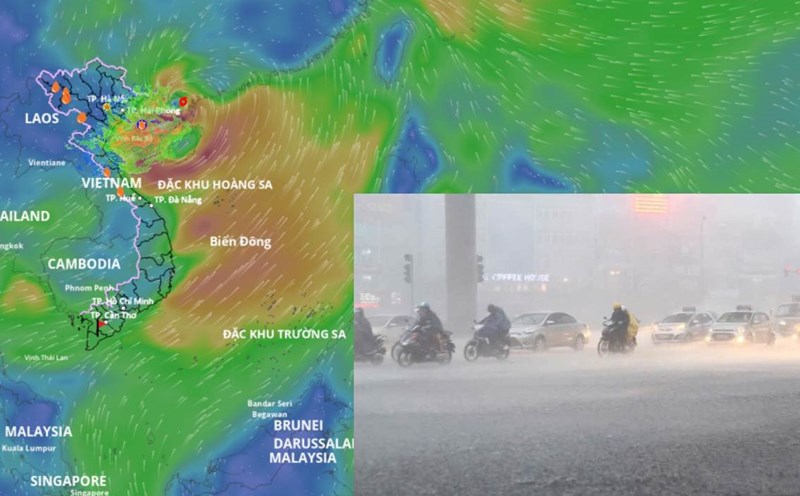
The North and North Central regions face many heavy rains
Regarding temperature trends, the temperature in most areas is generally at a level close to the average of many years in the same period, especially in the Central - Southern plateau, the average temperature is about 0.5 - 1 degree Celsius higher than the average of many years in the same period.
According to Mr. Nguyen Duc Hoa - Deputy Head of the Climate Forecast Department, National Center for Hydro-Meteorological Forecasting, hot weather continues to occur in the provinces from Thanh Hoa to Hue and the South Central Coast. However, the heat is gradually decreasing in intensity and frequency.

The total rainfall in the coastal areas of the North, the provinces from Thanh Hoa to Hue, Quang Ngai is 10 - 30% higher than the average of many years, the remaining areas have total rainfall at a level approximately equal to the average of many years in the same period.
"The Northern region and the provinces from Thanh Hoa to Hue are likely to experience some widespread heavy rains. In the Central and Southern highlands, there are many days of the month with showers and thunderstorms, mainly in the late afternoon; in which, some days may have moderate to heavy rain" - Mr. Hoa said.
On a national scale, there is a continued possibility of dangerous weather phenomena such as thunderstorms, tornadoes, lightning, hail and strong gusts of wind.
The phenomenon of heavy rain and thunderstorms, whirlwinds, and lightning can negatively affect production activities and public health. In particular, beware of localized heavy rains that can cause floods, inundation in low-lying areas and landslides in mountainous areas.
Previously, from July 21 to August 20, the North had many rainy days, including 4 widespread heavy rains. Notably, the rain lasted from July 19 to 27, due to the impact of storm No. 3.
Thanh Hoa to Hue and the South Central Coast will have 3 widespread showers and thunderstorms. A typical example is the rain from August 16 to 18, due to the influence of the tropical convergence zone connecting with the tropical depression.
The Central and Southern Highlands region will experience many days of showers and thunderstorms, including days of moderate to heavy rain.
Preventing land damage by storms
According to Mr. Hoa, during the forecast period, the number of storms and tropical depressions in the East Sea will be equivalent to the average of many years in the same period.
According to the average data of many years, in the same period in the East Sea, there will be about 2.4 storms or tropical depressions (ie about 2 - 3 storms), 1 of which will make landfall in Vietnam.
Storms, tropical depressions and the southwest monsoon are likely to cause strong winds, large waves at sea and affect the activities of ships.

Of which, storm No. 5 is active in the East Sea and is likely to strengthen.
According to Mr. Mai Van Khiem - Director of the National Center for Hydro-Meteorological Forecasting, when entering the sea area from Thanh Hoa to Hue, the strongest wind near the storm center is level 11 - 12, gusting to level 15.
"From the night of August 24 to the end of August 26, storm No. 5 will cause widespread heavy rain in the Northern Delta and from Thanh Hoa to Hue" - Mr. Khiem said.
Previously, in the period from July 21 to August 20, there were 2 storms and 2 tropical depressions in the East Sea, of which storm No. 3 Wipha and tropical depression in mid-August 2025 directly affected our mainland.