Latest forecast on location and path of tropical depression

AN AN |

According to the meteorological agency, the tropical depression will maintain its level 6 intensity and move northwest.

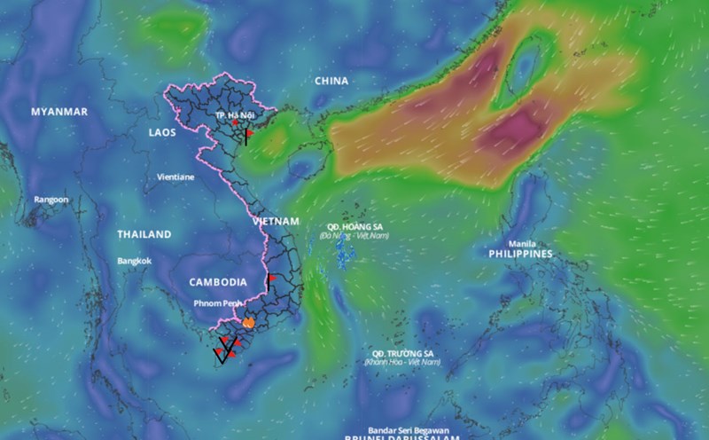
According to the National Center for Hydro-Meteorological Forecasting, at 1:00 p.m. on February 12, the center of the tropical depression was located at about 12.3 degrees north latitude; 112.0 degrees east longitude, in the area northwest of Truong Sa archipelago. The strongest wind near the center of the tropical depression was level 6 (39 - 49 km/h), gusting to level 8.

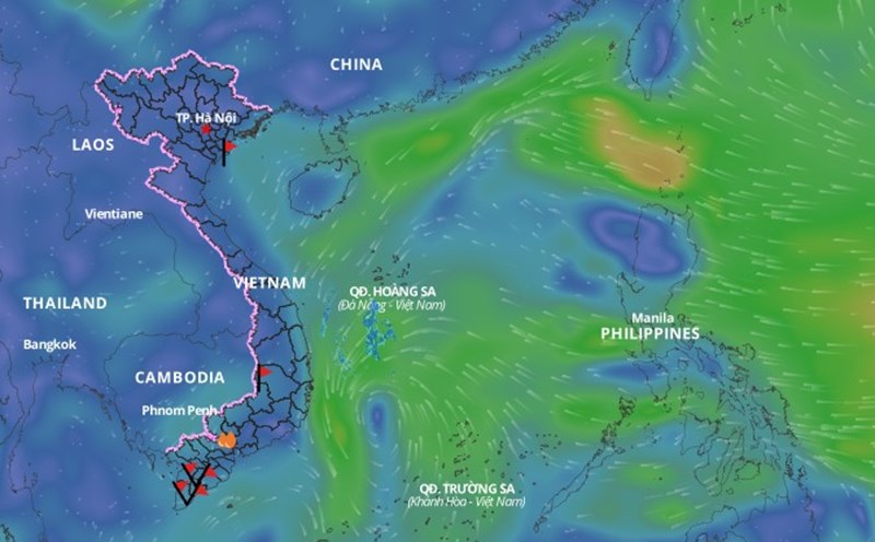
In the next 24 hours, the tropical depression is forecast to move northwest at a speed of about 5 km/h. At 1:00 p.m. on February 13, the center of the tropical depression will be at about 13 degrees north latitude - 111.3 degrees east longitude; in the sea west of the central East Sea. The strongest wind near the center of the tropical depression is at level 6, gusting to level 8.

The dangerous area due to tropical depression is around 11 - 14.5 degrees north latitude; 110 - 113.5 degrees east longitude.

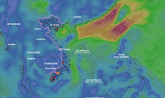
It is forecasted that in the next 48 hours, the tropical depression will move northwest at a speed of about 5 km/h. At 1:00 p.m. on February 14, the center of the tropical depression will be at about 14 degrees north latitude - 110.5 degrees east longitude; in the offshore waters from Quang Ngai to Phu Yen. The strongest wind near the center of the tropical depression will be at level 6, gusting to level 8.

The dangerous area due to tropical depression is at about 11.5 - 15.5 degrees north latitude; west of longitude 112.5 degrees east.

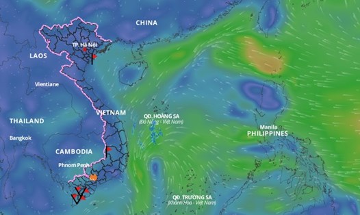
Over the next 48 to 72 hours, the tropical depression will move slowly northwestward and gradually weaken.

Regarding the impact of the tropical depression, the western sea area of ​​the area between the East Sea and the southwestern sea area of ​​the North East Sea; the offshore sea area from Binh Dinh to Khanh Hoa has showers and heavy thunderstorms, strong winds of level 6, gusts of level 8, rough seas.

The western sea area between the East Sea and the southwestern sea area of ​​the North East Sea (including the Hoang Sa archipelago) has waves 2 - 3.5m high. From February 14, the offshore sea area from Thua Thien Hue to Binh Dinh has waves 2 - 3m high.

Ships operating in the above mentioned dangerous areas are likely to be affected by storms, whirlwinds, strong winds and large waves.

AN AN
RELATED NEWS

Rain is forecast for the area as cold air strengthens

|

According to the meteorological agency, cold air will increase its impact on the Northeast and North Central regions from tonight, February 12.

Latest forecast of the path of the first tropical depression in 2025

|

According to the meteorological agency, the tropical depression in the East Sea has a strong intensity of level 6, gusting to level 8.

The first tropical depression appears in the East Sea in 2025

|

This morning (February 12), the low pressure area in the central East Sea has strengthened into a tropical depression.

Lao Cai elects Chairman and 5 Vice Chairmen of the Provincial People's Committee

|

Lao Cai - At the first session, the 17th Provincial People's Council elected the positions of Chairman and Vice Chairmen of the Provincial People's Committee, term 2026-2031.

Mr. Tran Duy Dong re-elected Chairman of Phu Tho Provincial People's Committee

|

Phu Tho - On March 27, at the first session of the Phu Tho Provincial People's Council, term XX, Mr. Tran Duy Dong was re-elected as Chairman of the Provincial People's Committee with 100% of the votes in favor.

Prime Minister reappoints Deputy Minister of Foreign Affairs Dang Hoang Giang

|

Prime Minister Pham Minh Chinh decided to reappoint Mr. Dang Hoang Giang to the position of Deputy Minister of Foreign Affairs.

The moment soil and rocks slid down, killing a worker

|

Thai Nguyen - The moment of soil and rocks falling down happened too quickly, many people present at the scene could not react in time.

Rain is forecast for the area as cold air strengthens

NHÓM PV |

According to the meteorological agency, cold air will increase its impact on the Northeast and North Central regions from tonight, February 12.

Latest forecast of the path of the first tropical depression in 2025

NHÓM PV |

According to the meteorological agency, the tropical depression in the East Sea has a strong intensity of level 6, gusting to level 8.

The first tropical depression appears in the East Sea in 2025

AN AN |

This morning (February 12), the low pressure area in the central East Sea has strengthened into a tropical depression.