According to storm news, the latest low pressure from the Philippine Atmospheric, Geophysical and Astronomical Services Administration (PAGASA), the weakening tropical depression from Typhoon Hagupit is continuing to move deep into the Philippine area of responsibility.
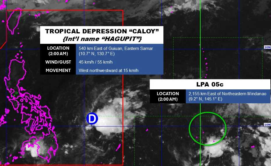
As of 2 am on May 11, the center of the tropical depression was located at about 10.7 degrees North latitude - 130.7 degrees East longitude, about 540 km east of Guiuan, eastern Samar.
The strongest wind near the center of the tropical depression reached 45 km/h, gusting up to 55 km/h. The tropical depression is moving in a West - Northwest direction at a speed of 15 km/h, towards the mainland Philippines.
However, PAGASA forecasts that the tropical depression will quickly weaken into a low-lying area and gradually dissipate in the next 24 hours, before entering the mainland of central Philippines.
Meanwhile, the low pressure area coded LPA 05C is also moving closer to the Philippine area of responsibility.
The center of the low pressure is located at about 9.2 degrees North latitude - 145.1 degrees East longitude, about 2,155 km west of the Northwest Mindanao region.
This low pressure area is forecast to have little chance of strengthening into a tropical depression or storm in the next 24 hours.
In the East Sea, according to the National Center for Hydro-Meteorological Forecasting, early this morning, May 11, the sea area from Ho Chi Minh City to Ca Mau, Ca Mau to An Giang and the Gulf of Thailand will have showers and thunderstorms.
Forecast for the day and night of May 11, the sea area from Ho Chi Minh City to Ca Mau, Ca Mau to An Giang and the Gulf of Thailand will have scattered showers and thunderstorms. In thunderstorms, there is a possibility of tornadoes and strong gusts of wind.
All ships operating in the above areas are at risk of being affected by tornadoes and strong gusts of wind.
People and tourists planning to visit these sea areas should pay attention to weather forecasts. Avoid going out to sea when the sea is rough and follow local instructions to avoid storms and big waves at sea that are dangerous.


