According to storm news, the latest low pressure from the Joint Typhoon Warning Center (JTWC), the weakening tropical depression from Typhoon Hagupit is moving inside the Philippine area of responsibility.
The center of the tropical depression is located at about 10.3 degrees North latitude - 133.3 degrees East longitude, about 391 km north - Northwest of Angaur. In the past 6 hours, the tropical depression has moved in a northwest direction at a speed of 17 km/h. The highest wave height reached about 4.3 m.
The strongest wind near the center of the tropical depression reached 55 km/h, gusting up to 70 km/h. The tropical depression is moving in the Northwest direction at a speed of about 15 km/h.
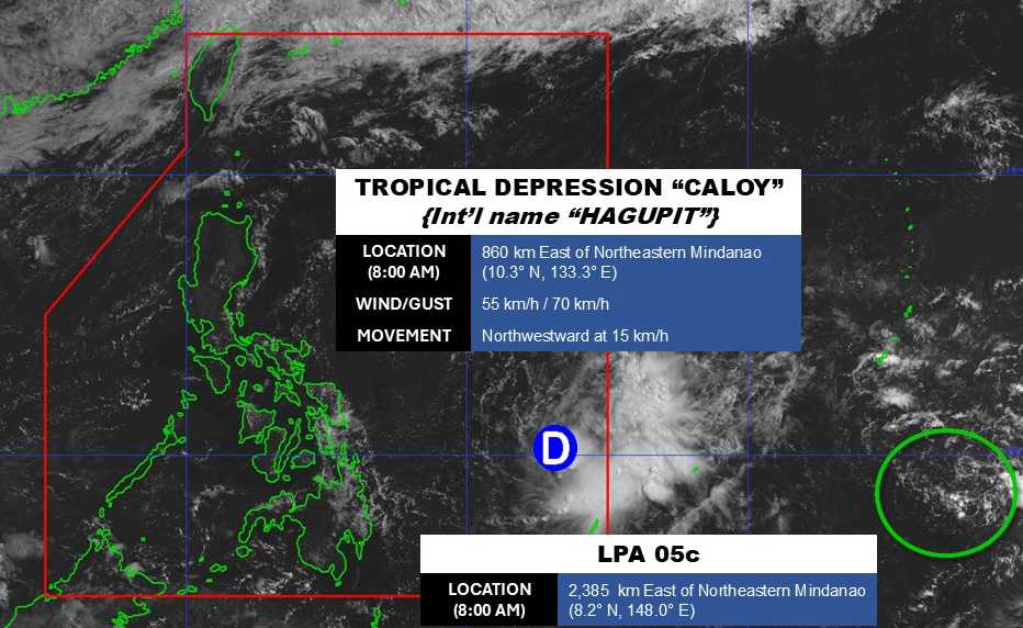
Not far away, the low pressure bearing the symbol Invest 95W is moving over the Pacific Ocean. The center of the low pressure is located at about 8.2 degrees North latitude - 148.0 degrees East longitude, about 860 km east of the Northeast of Mindanao.
The strongest wind near the center of the low pressure reached 30 km/h. The low pressure is unlikely to develop into a tropical depression in the next 24 hours.
In the East Sea, according to the National Center for Hydro-Meteorological Forecasting, on the day and night of May 10, the North and South Gulf of Tonkin areas will have showers and thunderstorms in some places, visibility over 10km. Northeast to easterly wind level 3-4, waves from 0.5-1.5m high.
The sea area from southern Quang Tri to Khanh Hoa has showers and thunderstorms in some places, visibility over 10km. Light wind, waves from 0.5-1.5m high.
The sea area from Lam Dong to An Giang and the Gulf of Thailand has scattered showers, with thunderstorms in some places. In thunderstorms, there is a possibility of tornadoes and strong gusts of wind. Visibility over 10km, reduced to 4-10km in rain. Northeast to southeast wind level 3-4, especially the Gulf of Thailand light wind. Waves high from 0.5-2.0m.
In the Northern East Sea area, Hoang Sa special zone and the central East Sea area, there are showers and thunderstorms in some places, visibility over 10km. Northeast wind level 3-5, waves 1.0-2.5m high.
The South East Sea and Truong Sa special zone have scattered showers and thunderstorms in some places. In thunderstorms, there is a possibility of tornadoes and strong gusts of wind. Visibility over 10km, reduced to 4-10km in rain. Northeast to easterly wind level 4-5, waves 1.0-2.0m high.
People and tourists planning to visit these sea areas should pay attention to weather forecasts. Follow local instructions and avoid going to sea when the sea is rough to ensure safety.


