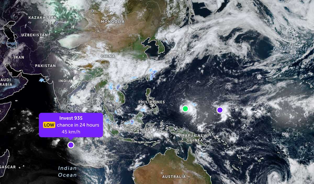
According to storm news, the latest low pressure from the Joint Typhoon Warning Center (JTWC), low pressure Invest 93S is strengthening over the Indian Ocean.
As of the morning of May 8, the center of the low pressure was located in the Southwest Indian Ocean. The strongest wind near the center of the low pressure reached 45 km/h. The low pressure is forecast to have a low probability of developing into a tropical depression in the next 24 hours.
Meanwhile, Typhoon Hagupit is currently about 374 km east-southeast of Yap and has moved in a West-Northwest direction at a speed of about 15 km/h in the past 6 hours. The maximum sea wave is about 4.6 m high.
It is forecasted that in the near future, Hagupit will continue to move in a West-Northwest direction under the impact of a subtropical high pressure in the Northeast. The storm's intensity may strengthen to about 75 km/h in the next 12 hours. However, the system still has to be affected by middle-level faulty winds and dry air intrusion, making it difficult to maintain strong intensity for a long time.
According to forecasts, Typhoon Hagupit will continue to enter sea areas with unfavorable conditions, starting to weaken significantly after about 3 days and is likely to dissipate at sea after about 5 days.
Not far away, the low pressure bearing the symbol Invest 95W is currently operating in the Western Pacific region. The strongest wind near the center of the low pressure reaches 30 km/h. This low pressure is unlikely to develop into a tropical depression in the next 24 hours.
In the East Sea, according to the National Center for Hydro-Meteorological Forecasting, this morning May 8, the sea area from Ca Mau to An Giang and the Gulf of Thailand had scattered showers and thunderstorms.
Forecast for the evening and night of May 8, the Northeast of the Northern East Sea area has strong Northeast wind at level 6, gusting at level 7-8, rough seas; waves 2.0-3.0m high.
In addition, on the day and night of May 8, the sea area from Lam Dong to Ca Mau, Ca Mau to An Giang, the Gulf of Thailand and the South East Sea area (including Truong Sa special zone) will have scattered showers and thunderstorms. On May 8, the Gulf of Tonkin area will have scattered showers and thunderstorms. In thunderstorms, there is a possibility of tornadoes and strong gusts of wind.
From May 9, winds in the northeastern sea area of the Northern East Sea will gradually weaken.
All ships operating in the above areas are at high risk of being affected by strong winds, big waves, tornadoes and strong gusts of wind during thunderstorms. People and tourists going to sea should pay attention to weather, avoid rough seas areas to ensure safety.


