According to storm news, the latest low pressure from the Joint Typhoon Warning Center, a low pressure is moving over the Pacific Ocean.
By the evening of June 14, the center of the low pressure area with the symbol Invest 92W is currently located in the Western Pacific region. The low pressure area is moving in a West-Northwest direction, towards the area of responsibility of the Philippines and the East Sea.
However, the low pressure is still very far from the Philippine area of responsibility, so it has not had much impact on the mainland of this country.
The strongest wind near the low pressure center reaches 30 km/h. The low pressure has little chance of strengthening into a tropical depression or storm in the next 24 hours.
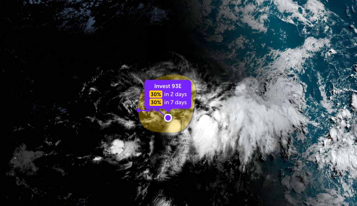
Meanwhile, the low pressure bearing the symbol Invest 93E is currently located in the East Pacific region. The strongest wind near the center of the low pressure reaches 30 km/h.
The low pressure area located far southwest of the Baja California peninsula is causing showers and thunderstorms. The low pressure is moving in a Northeast to Northeast direction at a speed of about 8-16 km/h.
This low pressure has a 30% chance of developing into a tropical depression or tropical storm within the next 2 days and a 30% chance within the next 7 days.
According to the National Center for Hydro-Meteorological Forecasting, on June 15, the coastal sea areas of Vietnam will generally have showers and thunderstorms in some places, especially the North of the Gulf of Tonkin will have scattered showers and thunderstorms. The main wind is South to Southwest at level 4-5, especially the North of the Gulf of Tonkin sometimes at level 6, gusts at level 7-8, rough seas. Sea waves are common from 0.5-2.5m.
In the East Sea, the Northern East Sea area and the Hoang Sa sea area have Southwest wind level 5, sometimes level 6, gusts level 7-8, rough seas, waves 1.5-2.5m high. The Central and Southern East Sea areas, including the Truong Sa area, have scattered showers and thunderstorms, Southwest wind level 3-5, waves 1-2.5m high.
During thunderstorms, sea areas are likely to experience tornadoes, strong gusts of wind and high sea waves, affecting the operation of ships and boats.
People and tourists planning to visit these sea areas should pay attention to weather forecasts. Avoid going out to sea when the sea is rough to ensure safety.


