Low pressure moves complicatedly, highly likely to become a storm

Chí Long |

It is forecast that the low pressure in the Pacific Ocean is highly likely to strengthen into a tropical depression or tropical storm in the next 24 hours.

According to storm news, the latest low pressure from the Joint Typhoon Warning Center (JTWC), two low pressures are strengthening in the Pacific Ocean.

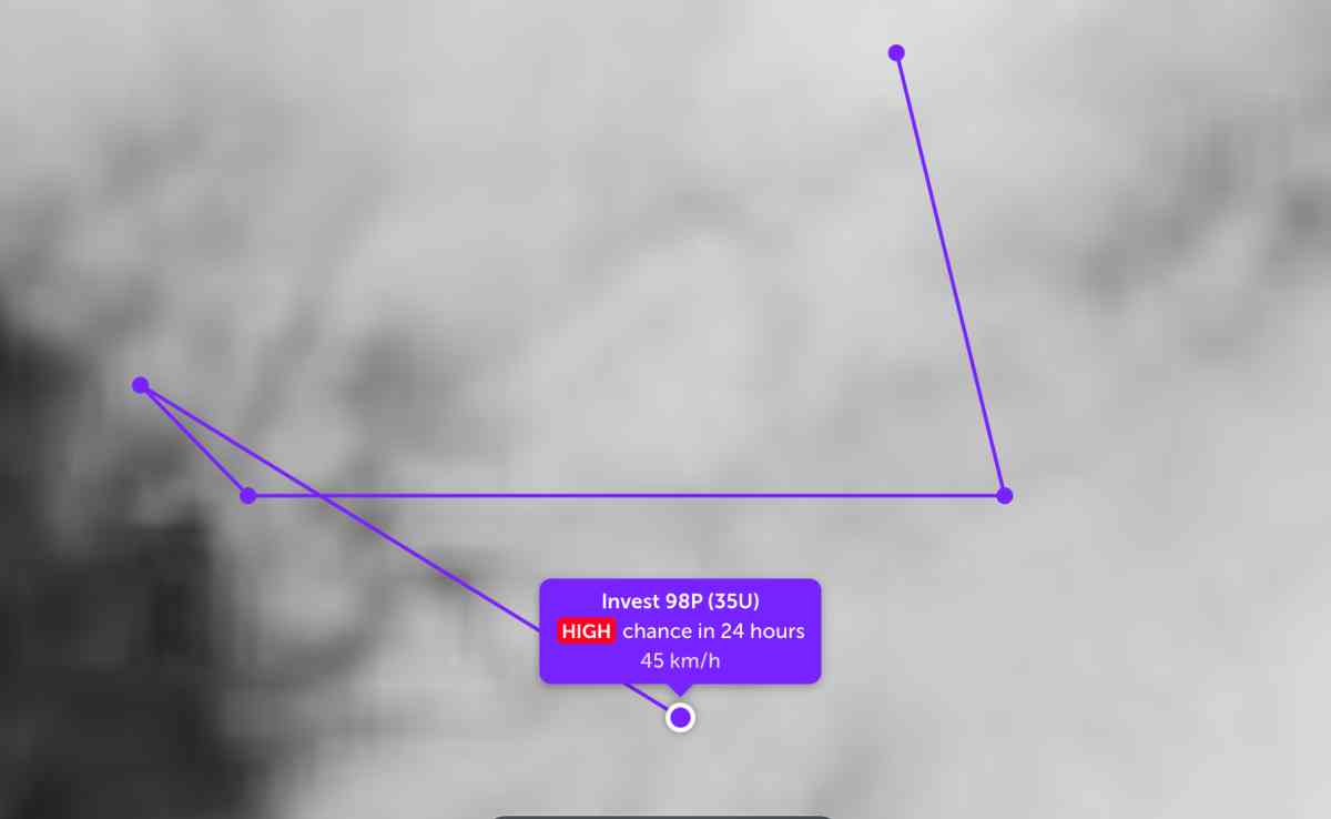
The low pressure bearing the symbol Invest 98P (Tropical Low 35U) follows the zic zac line in the South of the Solomon Islands, in the South Pacific. The strongest wind near the center of the low pressure reaches 45 km/h.

JTWC forecasts that the low pressure is highly likely to develop into a tropical depression or storm in the next 24 hours.

Áp thấp di chuyển theo đường zic zac trên biển Thái Bình Dương. Ảnh: JTWC
The low pressure moves in a zigzag motion over the Pacific Ocean. Photo: JTWC

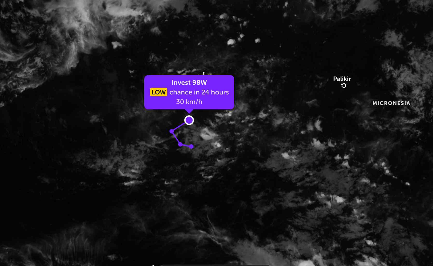
Meanwhile, the low pressure bearing the symbol Invest 98W also follows an arc with a small radius in the western Pacific region. The strongest wind near the center of the low pressure reaches 30 km/h. The low pressure is unlikely to develop strongly into a tropical depression in the next 24 hours.

Áp thấp còn lại di chuyển theo đường vòng cung. Ảnh: JTWC
The remaining low pressure moves in an arc. Photo: JTWC

On land in Australia, Super Typhoon Narelle has weakened to tropical storm level. The storm's center is currently located 259 km southeast of Darwin, Australia. The strongest wind near the storm's center reaches 75 km/h. In the past 6 hours, the storm has moved west at a speed of 22 km/h.

The storm is forecast to continue moving on this trajectory for the next 4 days. Hurricane Narelle will pass through Bonaparte Bay in about 18 hours before making its third landfall in North Wyndham.

The storm will move along the coast of Kimberley in the next 36 hours, then return to the Indian Ocean near Adele Island in the next 42 hours.

Cập nhật hướng đi của bão Narelle trên đất liền. Ảnh: JTWC
Update on the direction of Typhoon Narelle on land. Photo: JTWC

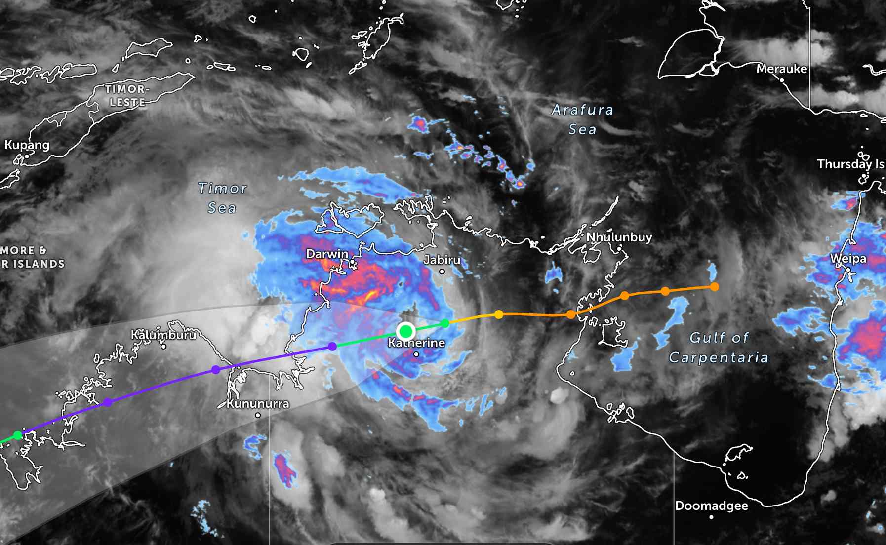
Typhoon Narelle is expected to continue moving southwest, parallel to the coast in the next 4 days, where it will approach the northwest edge of the subtropical high pressure range and shift further southwest.

The maximum intensity of 195-205 km/h is forecast to occur in about 4.5 days. After that, the storm will gradually weaken.

People and tourists planning to travel to Northern Australia and storm-affected areas should pay attention to weather forecasts. Check flight schedules and follow local instructions to ensure safety.

Chí Long
TIN LIÊN QUAN

Low pressure connects to low pressure appears, likely to strengthen within 24 hours

|

Two low pressure areas are operating in the Pacific Ocean, while Typhoon Narelle is raging on land.

Low pressure sweeps through land, super typhoon Narelle is about to make landfall for the 2nd time

|

The low pressure is forecast to strengthen when passing through the mainland of the Solomon Islands, while Super Typhoon Narelle is about to make landfall for the 2nd time.

Tropical depression turns into storm, likely to make landfall at the weekend

|

A tropical depression has strengthened into a tropical storm, likely to make landfall in Australia by the weekend with strong gusts of 155 km/h.

Low pressure connects to low pressure appears, likely to strengthen within 24 hours

Chí Long |

Two low pressure areas are operating in the Pacific Ocean, while Typhoon Narelle is raging on land.

Low pressure sweeps through land, super typhoon Narelle is about to make landfall for the 2nd time

Chí Long |

The low pressure is forecast to strengthen when passing through the mainland of the Solomon Islands, while Super Typhoon Narelle is about to make landfall for the 2nd time.

Tropical depression turns into storm, likely to make landfall at the weekend

Dương Đông |

A tropical depression has strengthened into a tropical storm, likely to make landfall in Australia by the weekend with strong gusts of 155 km/h.