According to the National Center for Hydro-Meteorological Forecasting, a tropical depression is strengthening over the East Sea.
As of 13:00 on July 2nd, the center of the tropical depression is located at about 17.4 degrees North latitude - 112.2 degrees East longitude, over the sea area north of the Hoang Sa special zone. The strongest wind near the center of the tropical depression is strong at level 7 (50-61 km/h), gusting at level 9. The tropical depression is moving in a West-Northwest direction at a speed of about 25 km/h.
It is forecasted that by 1:00 PM on July 3, the tropical depression will move in the Northwest direction at a speed of 10-15 km/h, located on the coastal mainland southeast of Hainan Island (China). The system is likely to strengthen into a storm with intensity level 8-9, gusts level 10-11.
The dangerous area at sea during this time is in the range from 16.0-10.0 degrees North latitude and from 109.0-114.0 degrees East longitude. Disaster risk level 3 applies to the west of the Northern East Sea area, including the Hoang Sa special zone.
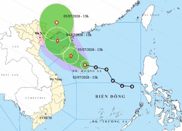
By 1:00 PM on July 4th, the storm is expected to continue moving in a Northwest direction at a speed of 10-15 km/h, entering the Northern Gulf area. The storm intensity is maintained at level 8, gusting at level 10.
The dangerous area is expanded from 17.0-22.0 degrees North latitude and from 107.0-112.0 degrees East longitude. Disaster risk level 3 is warned for the northwestern sea area of the Northern East Sea and the Northern Gulf of Tonkin area.
From the next 48 to 72 hours, the storm is forecast to move in a North-Northwest direction at a speed of 10-15 km/h and gradually weaken into a tropical depression.
Due to the influence of the tropical depression about to strengthen into a storm, the sea area west of the Northern East Sea (including the Hoang Sa special zone) has strong winds of level 6-7, then increasing to level 8-9, waves 2.0-4.0m high, the area near the storm center 3.0-5.0m high, very rough seas.
From the night of July 3rd, the sea area of the Northern Gulf of Tonkin will gradually have strong winds of level 6-7, the area near the storm center passing through level 8, gusts of level 9-10, sea waves 2.0-4.0m high, strong rough seas.
Ships operating in the above-mentioned dangerous areas are likely to be affected by thunderstorms, tornadoes, strong winds, and large waves.
From the night of July 3rd to the end of July 5th, in the Northeast region and Thanh Hoa, there is a possibility of a widespread heavy rain with a common total rainfall of about 100-200mm, especially in the Northeast region 150-250mm, locally over 350mm.
People and tourists in areas affected by the tropical depression should closely monitor weather developments. Follow local instructions and avoid going out to sea when the sea is rough to ensure safety throughout the journey.


