According to the National Center for Hydro-Meteorological Forecasting, the tropical depression is strengthening in the East Sea.
As of 7:00 AM on July 2nd, the center of the tropical depression is located at about 17.1 degrees North latitude - 113.7 degrees East longitude, over the North East Sea area, about 240 km east-northeast of the Hoang Sa special zone.
The strongest wind near the center of the tropical depression reached level 7 (50-61 km/h), gusting to level 9. This weather system is moving in the West-Northwest direction at a speed of about 25 km/h.
Forecast for the next 24 hours, the tropical depression will slow down to about 10-15 km/h and continue to move in the West-Northwest direction.
By 7:00 AM on July 3rd, the center of the tropical depression is forecast to be at about 18.1 degrees North latitude - 110.9 degrees East longitude, in the sea area southeast of Hainan Island (China) and is likely to strengthen into a storm with winds of level 8-9, gusts of level 11-12.
It is forecast that the low pressure will make landfall on Hainan Island (China) on July 3.
By 7:00 AM on July 4th, the storm will continue to move in a Northwest direction at a speed of 10-15 km/h, entering the Northern Gulf area. The storm's center is located at about 20.1 degrees North latitude - 108.7 degrees East longitude, with a sustained intensity of level 8, gusts of level 10.
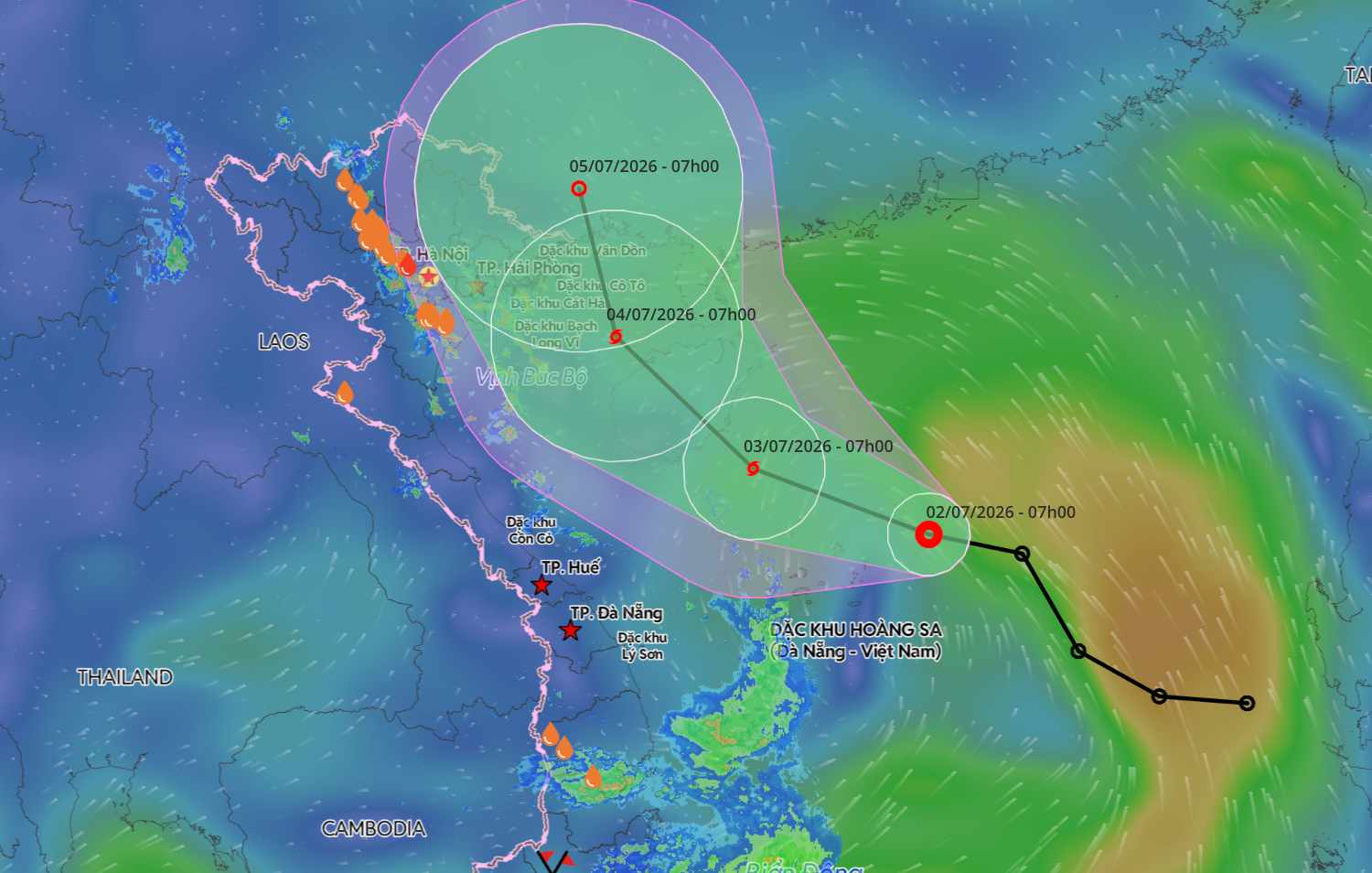
From the next 48 to 72 hours, the storm is forecast to turn North-Northwest, moving about 15 km per hour and gradually weakening.
The meteorological agency warns that in the next 24 hours, the dangerous sea area will be in the range from 16.5-19 degrees North latitude and from 109.5-115 degrees East longitude. The level of natural disaster risk due to strong winds at sea is level 3 for the Northern East Sea area, including the Hoang Sa special zone.
By July 4, the dangerous zone will expand from 17-21 degrees North latitude and from 107.5-1112 degrees East longitude. Disaster risk level 3 is maintained for the western sea area of the Northern East Sea (including the Hoang Sa special zone) and the Northern Gulf of Tonkin area.
Due to the influence of the tropical depression, the North East Sea area (including the Hoang Sa special zone) is experiencing strong winds of level 6-7, gusts of level 9, sea waves from 2-4 m high, strong rough seas. From the afternoon of July 2nd, the area near the storm center will have winds increasing to level 8, then strengthening to level 9, gusts of level 11-12; sea waves 3-5 m high, very strong rough seas.
Ships operating in the above-mentioned dangerous areas are at high risk of being affected by thunderstorms, tornadoes, strong winds and big waves. Therefore, people and tourists planning to go to these sea areas need to regularly update the latest developments of the tropical depression, proactively adjust their schedules, and not enter dangerous areas to ensure safety for people and property.


