According to the latest storm news from the Joint Typhoon Warning Center (JTWC), Typhoon Mitchell - the predecessor of a tropical depression formed inland - is moving west-southwest over the waters off West Australia.
The storm moves at a speed of about 17 km/h. The highest sea waves in the area near the storm center reach 5.5 m.
The current scenario shows that the storm is likely to make landfall near the Exmouth Bay area after about 36 hours, but the specific landfall location may still change if the trajectory shifts slightly.
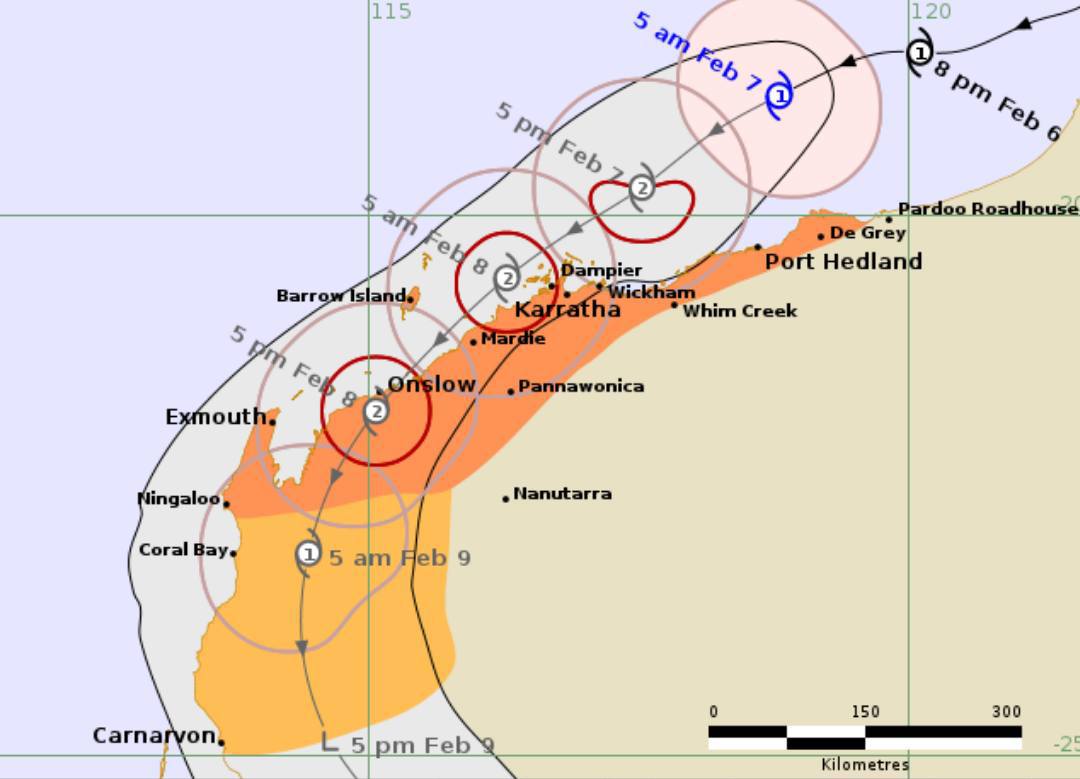
The Australian Bureau of Meteorology (BOM) said that at 8 am on February 7 (local time), Mitchell was at level 2 with sustained winds near the storm center at 95 km/h, gusts up to 130 km/h.
The eye of the storm is located about 145 km north of Port Hedland and about 255 km northeast of Karratha, is continuing to strengthen and may reach Category 3 overnight.
BOM forecasts a storm approaching the Pilbara coast today, moving near the shore on Sunday before turning south and going deep inland on Monday. gusts could reach 150-170km/h.
Widespread rain, heavy rain in some places, risk of flash floods from the end of today and lasting throughout the weekend.
It is forecast that storm Mitchell may strengthen very quickly in the next 24 hours, with wind intensity peaking at about 150 km/h thanks to very favorable environmental conditions. When approaching the Australian coast, the storm will begin to weaken.
Faced with the development of a tropical depression strengthening into a storm and continuing to intensify, tourists currently in or preparing to come to Western Australia, especially the coastal strip of Pilbara, need to continuously monitor weather forecast bulletins.
Sea tourism, fishing, diving, and boat sightseeing can be temporarily suspended. Strong winds, heavy rain, and flooding can also cause roads to be blocked, flight schedules to be changed or canceled. Tourists should proactively work with airlines and accommodation establishments and comply with all evacuation and safety instructions from local authorities.
Meanwhile, in the East Sea, cold air is affecting the weather in many areas.
According to the National Center for Hydro-Meteorological Forecasting, on February 7th, in the Gulf of Tonkin, the wind will shift to Northeast direction at level 5, sometimes level 6; from the night of February 7th, it will gradually strengthen to level 6-7, gusting to level 8-9, strong sea waves, waves 2.0-3.0m high.
Northern East Sea (including Hoang Sa special zone) from near dawn on February 7th, Northeast wind gradually strengthens to level 6-7, the northeast sea area sometimes level 8, gusts level 9-10, strong rough seas, waves 4.0-6.0m high.
From the night of February 7th, the sea area from South Quang Tri to Dak Lak will gradually have strong northeast winds of level 6, gusts of level 7-8, rough seas, waves 2.0-4.0m high.
From February 8th, the sea area from Khanh Hoa to Ca Mau, the area between the East Sea and the sea area west of the South East Sea (including the sea area west of Truong Sa special zone) will gradually strengthen to level 6, sometimes level 7, gusts level 8-9, strong rough seas, sea waves 3.0-5.0m high.


