According to the latest weather forecast from the Philippine Atmospheric, Geophysical and Astronomical Services Administration, a tropical depression (Mirasol) is intensifying as it leaves the Philippine mainland.
As of 8:00 a.m. on September 17, the center of the tropical depression was at about 16.7 degrees North latitude - 121.6 degrees East longitude, in the mainland area of Santiago, Isabela. The strongest wind near the center of the tropical depression reached 55 km/h, gusting up to 90 km/h.
The tropical depression is moving northwest at a speed of about 15 km/h. PAGASA forecasts that this tropical depression will strengthen into storm No. 8 when it enters the East Sea in the next 24 hours.
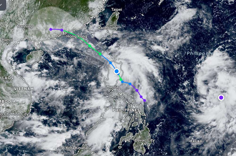
Meanwhile, another tropical depression has formed outside the Philippine Area of Responsibility (PAR). The center of the tropical depression is located at about 13.6 degrees North latitude - 136.5 degrees East longitude, about 1,330 km east of Virac, Catanduanes.
Due to the influence of the low pressure, the Batanes and Cagayan regions including Babuyan Islands, Isabela, Quirino, New Mexico Vizcaya, the northern and central parts of Aurora (Dilasag, Casiguran, Dinalungan, Dipaculao, Baler, Maria Aurora, San Luis) and Polillo Islands will have strong winds and heavy rain. During thunderstorms, floods and landslides may occur.
The National Center for Hydro-Meteorological Forecasting predicts that by 7:00 a.m. on September 18, the location of tropical depression Mirasol will be at about 19.7 degrees North latitude - 118.9 degrees East longitude, in the northeastern sea of the East Sea.
Strong wind intensity level 8, gust level 10, likely to strengthen into storm No. 8. Natural disaster risk level: Level 3 for the northeastern sea of the East Sea.
At 7:00 a.m. on September 19, the center of storm No. 8 was at about 21.8 degrees North latitude - 116.8 degrees East longitude, in the northeastern sea of the East Sea, about 300km East Southeast of Hong Kong (China).
The strongest wind intensity will reach level 8-9, gusting to level 11, and is likely to strengthen. Natural disaster risk level: Level 3 for the northeastern sea of the East Sea.
People and tourists planning to visit areas where the tropical depression is about to become a storm should pay attention to weather forecasts. Check your flight schedule and follow local instructions.