According to the low pressure forecast from the Joint Typhoon Warning Center (JTWC), a low pressure area that just formed on January 28th has intensified into a storm off Madagascar in the early morning of January 30th (local time).
Storm Fytia is currently about 222 km east-southeast of Nacala city (Mozambique), moving slowly eastward at a speed of about 4 km/h in the past 6 hours.
The highest sea waves reached about 4.6 m, causing strong sea waves in the Mozambique Strait area.
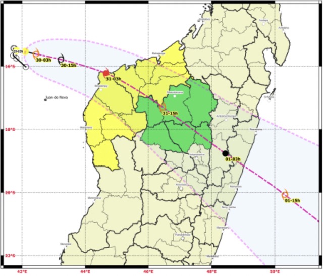
It is forecast that Typhoon Fytia will continue to move slowly in a southeast direction and make landfall in Madagascar in the next 24 hours.
During its movement across the Mozambique Strait, Typhoon Fytia is forecast to strengthen rapidly thanks to very favorable environmental conditions.
The storm will accelerate and quickly make landfall in Madagascar. The maximum wind intensity when making landfall is forecast to reach or exceed 120 km/h - typhoon level, strong enough to cause heavy rain, strong winds and dangerous sea waves.
Madagascar's high mountainous terrain will significantly weaken the storm. However, after about 2-3 days, when it returns to sea, the storm is likely to strengthen quickly if favorable conditions are met in the Indian Ocean.
Tourists planning to go to Madagascar, Mozambique or travel by cruise ship on the Mozambique Strait need to regularly follow the latest storm bulletins and proactively adjust their schedules.
Limit the operation of ships, diving and coastal sightseeing during the storm's impact; prevent heavy rain, flash floods and landslides in hilly areas of Madagascar.
Meanwhile, the weather at sea in Vietnam will be affected by the intensified cold air wave around the morning of January 31, according to the National Center for Hydro-Meteorological Forecasting.
Gulf of Tonkin from near dawn and January 31, wind turns Northeast strong at level 5, sometimes level 6, gusts level 7-8; rough seas, sea waves 1.0-2.0m high.
The northeastern sea area of the Northern East Sea has strong Northeast winds at level 6, gusts at level 7-8; rough seas, waves 2.0-4.0m high.
From February 1st, the Northern East Sea area (including Hoang Sa special zone), the sea area from Khanh Hoa to Ca Mau and the sea area west of the Southern East Sea area (including the sea area west of Truong Sa special zone) will gradually have strong Northeast winds of level 6, gusts of level 7-8; rough seas, waves 2.0-4.0m high.
From the afternoon and evening of February 1st, the western sea area of the Central East Sea and the sea area from South Quang Tri to Dak Lak will have strong Northeast winds of level 5, sometimes level 6, gusts of level 7-8; rough seas, waves 2.0-4.0m high.
On land, the weather in the Northern region will turn cold from January 31st. The lowest temperature in this cold air wave in the Northern and North Central regions is commonly 12-15 degrees Celsius, the Northern mountainous region 9-12 degrees Celsius, and the high mountainous region has places below 8 degrees Celsius.
From February 1st to the morning of February 4th, the area from Quang Tri to Da Nang City and the eastern provinces from Quang Ngai to Gia Lai will have rain, scattered showers and thunderstorms in some places.
People and tourists proactively keep warm and ensure health before weather changes.
Fishermen and sea tourists need to closely monitor weather developments and comply with the recommendations of local authorities.


