According to the National Center for Hydro-Meteorological Forecasting, on the afternoon of September 25, storm Bualoi strengthened to typhoon level.
At 1:00 p.m. on September 25, the center of the storm was at about 11.1 degrees North latitude - 128.1 degrees East longitude, in the sea east of the Philippines. The strongest wind near the storm center is level 12 (118-133 km/h), gusting to level 15.
The storm is moving west-northwest at a speed of 15-20 km/h.
It is forecasted that around the night of September 26, storm Bualoi will enter the eastern sea area of the Central East Sea, becoming storm No. 10 in 2025.
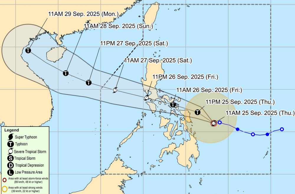
At 1:00 p.m. on September 26, the center of the storm was at about 13.1 degrees North latitude - 123.2 degrees East longitude. The strongest wind near the storm center is level 12, gusting to level 15. The storm is moving west-northwest at a speed of about 20 km/h.
It is forecasted that by 1:00 p.m. on September 27, the center of the storm will be at about 14.8 degrees North latitude - 117.5 degrees East longitude, entering the East Sea. The strongest wind near the storm center is level 12, gusting to level 15. The storm is moving west-northwest at a speed of about 20 km/h. Disaster risk level: Level 3 for the eastern part of the North and Central East Sea
At 1:00 p.m. on September 28, the center of the storm was at about 16.4 degrees North latitude - 111.0 degrees East longitude. The strongest wind near the storm center is level 12-13, gusting to level 16. The storm is moving west-northwest at a speed of 25 km/h, likely to strengthen. Disaster risk level: Level 3 for the North and Central East Sea (including Hoang Sa special zone)
Due to the influence of storm Bualoi, from the evening of September 26, the eastern sea area of the North and Central East Sea will have winds of level 6-7, then increase to level 8-9. The area near the storm center will reach level 10-12, gust level 15, waves 5-7m high, and rough seas.
Ship operating in the danger zone are likely to be affected by thunderstorms, whirlwinds, strong winds, and large waves.
People and tourists planning to travel to the Philippines or the sea areas where the storm passed should pay attention to weather forecasts. Check flight schedules and follow local instructions to avoid impactful storms.


