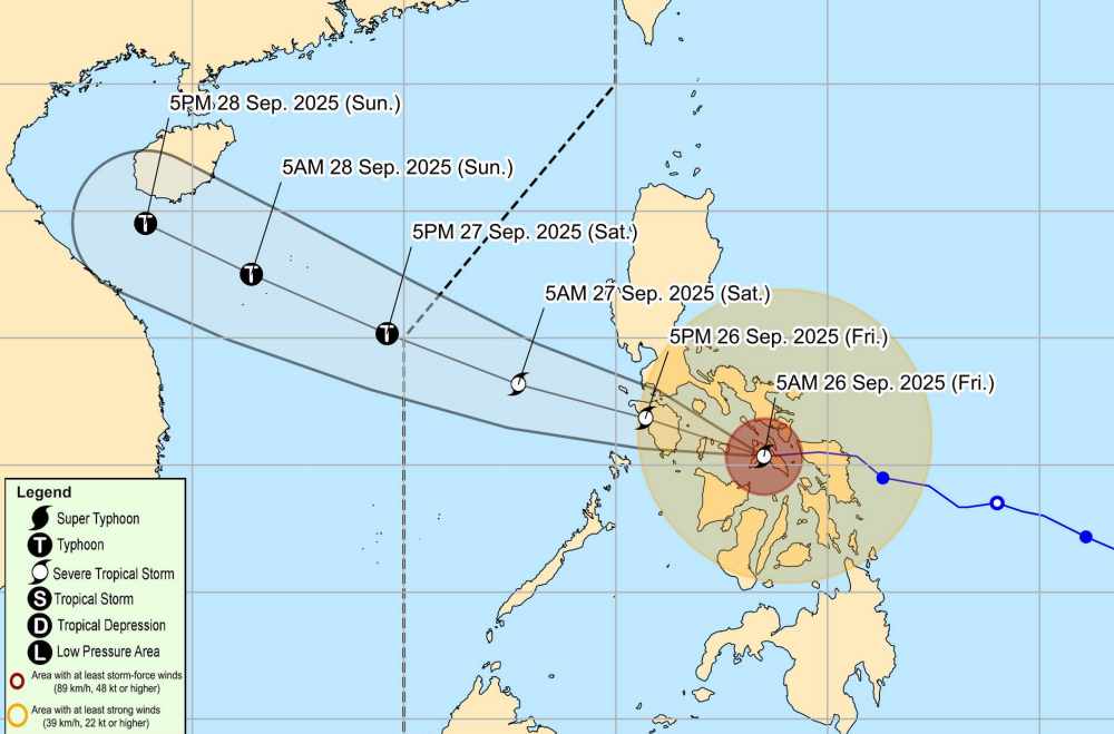
According to the Philippine Atmospheric, Geophysical and Astronomical Services Administration (PAGASA), on the morning of September 26, Typhoon Bualoi officially made landfall in the central Philippines.
As of 7:00 a.m., the center of the storm was at about 12.3 degrees North latitude - 123, 1 degree East longitude, in the coastal waters of Mandaon, Masbate. The storm is moving west-northwest at a speed of 30 km/h. Maximum sustained winds of 110 km/h near the center and gusts of up to 135 km/h.
Due to the impact of the storm, the central region of the Philippines will have heavy rain and strong gusts of wind.
The seas of Eastern Samar, Northern Samar, Samar, Biliran, Masbate (including the archipelagos of Ticao and burias; the southern and eastern coasts of Albay and Sorsogon) will have waves up to 11m high.
According to the National Center for Hydro-Meteorological Forecasting, by 7:00 a.m. on September 27, storm Bualoi moved in a West-Northwest direction at a speed of 30-35 km/h, entering the East Sea and tending to strengthen.
The center of the storm is located at about 14.5 degrees North latitude - 116.6 degrees East longitude. The strongest wind near the storm center is level 11-12, gusting to level 15. Natural disaster risk level: level 3 for the Northeast & Central East Sea.
It is forecasted that by 7:00 a.m. on September 28, the storm will move in a West-Northwest direction at a speed of about 30 km/h, continuing to strengthen. The center of the storm is located at about 16.7 degrees North latitude - 110.5 degrees East longitude. The strongest wind near the storm center is level 13, gusting to level 16. Natural disaster risk level: level 3 for the North & Central East Sea, Hoang Sa, and the sea area of South Quang Tri - Quang Ngai.
It is forecasted that in the next 72 to 96 hours, the storm will continue to move rapidly in the West Northwest direction at a speed of about 25 km/h and gradually weaken.
Due to the influence of the storm, from the afternoon of September 26, the northeastern and central East Sea will have winds of level 6-7, then increase to level 8-9. The area near the storm center has strong winds of level 10-12, gusts of level 15, waves 5.0-4.0 m high, and rough seas.
Ship in the danger zone are likely to be affected by thunderstorms, whirlwinds, and strong winds. People and tourists planning to visit these coastal areas should pay attention to weather forecasts and follow local instructions to ensure safety.


