Storm Ha Long is approaching super typhoon level, threatening to make landfall, with maximum winds of 230km/h

Ninh Phương |

Typhoon Ha Long rapidly strengthened from a tropical depression to a strong typhoon off the coast of Japan in just over 24 hours. The storm will approach super typhoon level.

The latest storm forecast from the Joint Typhoon Warning Center (JTWC) shows that Typhoon Ha Long will reach its peak intensity tonight, October 7, approaching the super typhoon, but still moving towards the southern coast of Japan.

The storm is currently located about 494 km west-northwest of Chichi Jima Island, moving northwest at a speed of 13 km/h over the past 6 hours. The maximum waves were recorded at about 9.1 m.

If Typhoon Ha Long continues its current path, the JTWC forecasts that the storm will move northwest, then turn north and northeast, approaching mainland Japan.

Du bao duong di cua bao Ha Long ngoai khoi Nhat Ban. Bao se di chuyen vong len sat dat lien. Anh: JMA
Forecast of the path of Typhoon Ha Long off the coast of Japan. The storm will move upward and near land. Photo: JMA

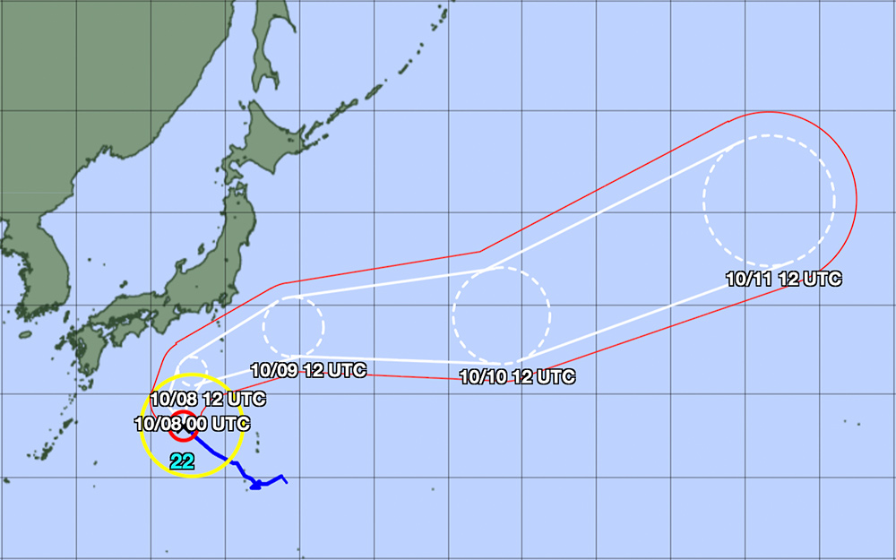
It is forecasted that in the next 24 hours, storm Halong will remain in a very favorable environment with warm sea surface temperatures (29-30°C), weak wind shear and good drainage conditions, to intensify violently as it approaches super typhoon level.

The storm is forecast to reach a maximum intensity of about 230 km/h within the next 36 hours, while noting the possibility of the storm strengthening before entering a rapid weakening phase.

This is a strong storm, likely to cause dangerous gusts of wind, heavy rain, storm surges, rough seas, landslides and localized flooding.

Tourists planning to travel by sea or air in the southern part of Japan (especially the Ogasawara and Izu Islands) on October 8-9 should closely monitor weather reports, adjust their itineraries accordingly and follow the instructions of local authorities.

Typhoon Ha Long is expected to continue to strengthen and change direction to the northeast, possibly approaching the Izu Islands on Thursday 8.10 with very strong intensity. The area will have strong winds and rough seas from 7.10, and the situation could become more dangerous on 8.10.

Ninh Phương
TIN LIÊN QUAN

Moc Chau submerged in floodwaters, tourists postpone tours due to storms

|

Son La - On October 6, many roads in the center of Moc Chau farm town were severely flooded due to the circulation of storm No. 11 causing heavy rain.

Storm No. 11 Matmo officially made landfall, strong waves hit the coast

|

Typhoon No. 11 Matmo made landfall in the coastal area of Zhejiang City, Guangdong Province (southern China) at around 2:50 p.m. (local time).

Storm Halong quickly appears right after storm No. 11 Matmo, about to intensify

|

Storm Halong quickly formed near the East Sea, while Typhoon No. 11 Matmo is heading towards the mainland area between the Vietnam - China border.

Moc Chau submerged in floodwaters, tourists postpone tours due to storms

Đan Thanh |

Son La - On October 6, many roads in the center of Moc Chau farm town were severely flooded due to the circulation of storm No. 11 causing heavy rain.

Storm No. 11 Matmo officially made landfall, strong waves hit the coast

Ninh Phương |

Typhoon No. 11 Matmo made landfall in the coastal area of Zhejiang City, Guangdong Province (southern China) at around 2:50 p.m. (local time).

Storm Halong quickly appears right after storm No. 11 Matmo, about to intensify

Ninh Phương |

Storm Halong quickly formed near the East Sea, while Typhoon No. 11 Matmo is heading towards the mainland area between the Vietnam - China border.