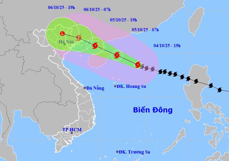
According to the storm news from the National Center for Hydro-Meteorological Forecasting, in the early morning of October 5, storm No. 11 is moving in a West-Northwest direction at a speed of 2025 km/h and tends to strengthen.
At 7:00 a.m., the center of the storm was at about 19.8 degrees North latitude - 111.9 degrees East longitude, in the northwest sea of the North East Sea, about 500 km East Southeast of Quang Ninh.
Strong storm intensity level 12-13, gust level 16. Level 3 natural disaster risk, mainly affecting the northwest sea area of the North East Sea and the eastern sea area of the North Gulf of Tonkin.
At 7:00 p.m. the same day, the storm continued to move in the West Northwest direction at a speed of 20-25 km/h.
The center of the storm is at about 20.9 degrees North latitude - 109.4 degrees East longitude, in the eastern sea of the Northern Gulf of Tonkin, about 190 km southeast of Quang Ninh.
The storm intensity decreased to level 11-12, gusting to level 15. The natural disaster risk level is still maintained at level 3, directly affecting the Northwest sea of the East Sea and the Northern Gulf of Tonkin.
According to the Joint Warning Center (JWTC), on the evening of October 5, typhoon No. 11 Matmo officially made landfall on Zhejiang Peninsula, China.
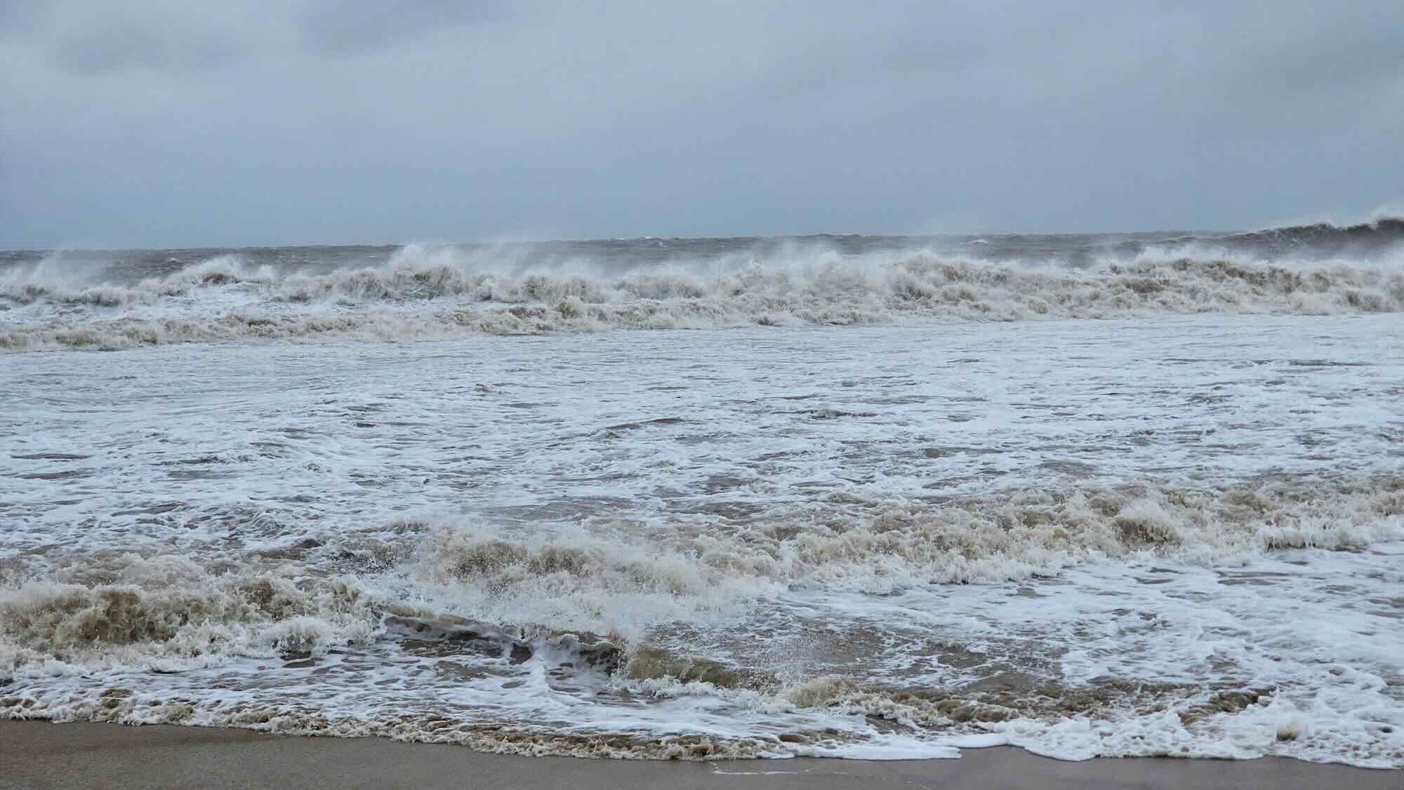
Due to the influence of the storm, from the afternoon of October 5, the sea area east of the North of the Gulf of Tonkin (including the Bach Long Vi special zone) will have winds gradually increasing to level 6-7, then increasing to level 8-9.
From the evening of October 5, the North of the Gulf of Tonkin (including the special areas of Bach Long Vy, Van Don, Co To, Cat Hai and Hon Dau island) will gradually increase to level 8-9, waves 2.0-4.0m high, the area near the storm's eye will have level 10-11, gusts of level 14, waves 3.0-5.0m high, rough seas (very dangerous for ships).
From the night of October 5, on the mainland in the coastal area from Quang Ninh to Hung Yen, the wind will gradually increase to level 6-7, near the storm's eye level 8-9, gusting to level 10-11. (The wind broke tree branches and blew off the roofs, causing damage to houses. Can't go against the wind). The deep inland area of the Northeast will have strong winds of level 4-5, some places will have level 6, gusting to level 7-8.
From the night of October 5 to the end of the night of October 7, in the mountainous and midland areas of the North, there will be heavy rain, with common rainfall from 150-250mm, locally very heavy rain over 400mm. Warning of the risk of heavy rain (over 150mm/3 hours); Dong Bang Northern region, Thanh Hoa has moderate rain, heavy rain with common rainfall of 70-150mm, locally very heavy rain over 200mm.
The Hanoi area is less likely to be affected by storms.
People and tourists planning to visit coastal areas and where the storm passes should pay attention to weather forecasts. Tuan follows local instructions to avoid dangerous storms.
Weather forecast for today, October 5th nationwide:
Hanoi
Lowest temperature: 24-26°C
Highest temperature: 32-34°C
Cloudy, sunny during the day; from the evening there will be occasional showers and thunderstorms. Northwest to north wind level 2-3. During thunderstorms, there is a possibility of tornadoes, lightning and strong gusts of wind.
Northwest
Lowest temperature: 23-26°C, some places below 22°C
Highest temperature: 31-34°C
Cloudy, scattered showers and thunderstorms, sunny days. Light wind. During thunderstorms, there is a possibility of tornadoes, lightning and strong gusts of wind.
Northeast
Lowest temperature: 23-26°C, mountainous areas below 23°C
Highest temperature: 31-34°C
Cloudy, with showers and thunderstorms in some places, from the afternoon there will be scattered showers and thunderstorms, locally heavy rain in some places. Northwest to north wind level 2-3. During thunderstorms, there is a possibility of tornadoes, lightning and strong gusts of wind.
Thanh Hoa to Hue
Lowest temperature: 24-27°C
Highest temperature: 31-34°C
Cloudy, scattered showers and thunderstorms, sunny days. West to southwest wind level 2-3. During thunderstorms, there is a possibility of tornadoes, lightning and strong gusts of wind.
South Central Coast
Lowest temperature: 24-27°C
Highest temperature: 31-34°C
Cloudy, scattered showers and thunderstorms, sunny days. Southwest wind level 2-3. During thunderstorms, there is a possibility of tornadoes, lightning and strong gusts of wind.
Central Highlands
Lowest temperature: 19-22°C
Highest temperature: 29-32°C
Cloudy, with showers and thunderstorms in some places; in the late afternoon and evening, there will be scattered showers and thunderstorms, with some places having heavy rain. Southwest wind level 2-3. During thunderstorms, there is a possibility of tornadoes, lightning and strong gusts of wind.
Southern region
Lowest temperature: 24-27°C
Highest temperature: 31-34°C
Cloudy, with showers and thunderstorms in some places; in the late afternoon and evening, there will be scattered showers and thunderstorms, with some places having heavy rain. Southwest wind level 2-3. During thunderstorms, there is a possibility of tornadoes, lightning and strong gusts of wind.
Ho Chi Minh City
Lowest temperature: 24-26°C
Highest temperature: 32-34°C
Cloudy, with showers and thunderstorms in some places; in the late afternoon and evening, there will be scattered showers, with some places having heavy rain. Southwest wind level 2-3. During thunderstorms, there is a possibility of tornadoes, lightning and strong gusts of wind.


