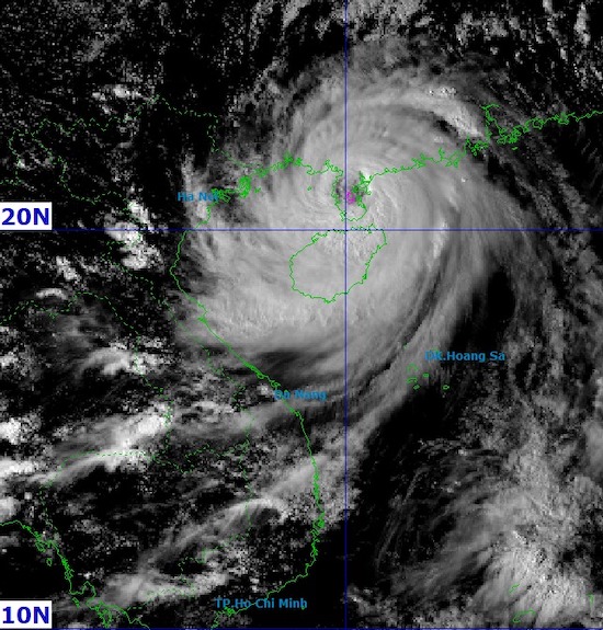
According to the latest storm information from the Quang Dong Provincial Meteorological Station, when making landfall, Typhoon Matmo will have maximum winds near the center reaching 42 m/s (equivalent to level 14 Beaufort, about 151 km/h).
The Joint Typhoon Warning Center (JTWC) recorded maximum waves in the area affected by Typhoon Matmo currently reaching about 11 m.
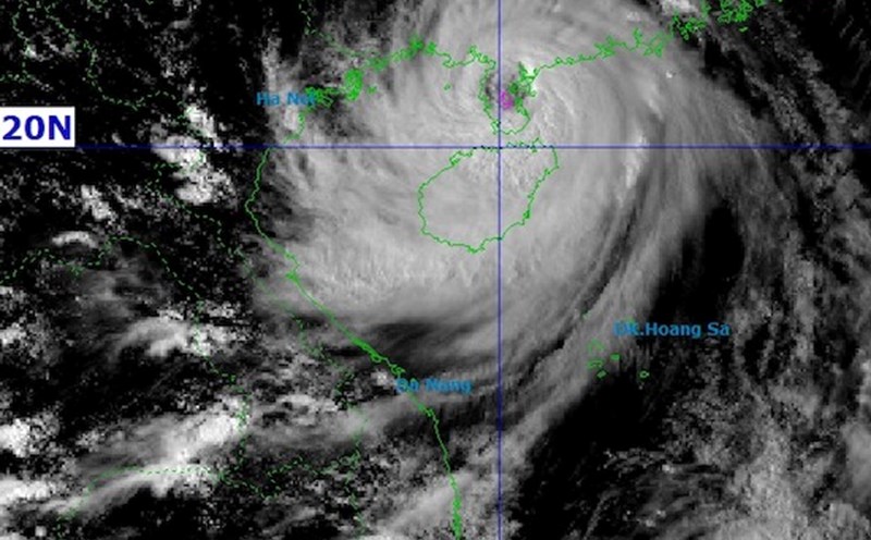
According to the National Center for Hydro-Meteorological Forecasting, at around 3:00 p.m. on October 5, storm No. 11 had the strongest wind: Level 12-13 (118-149km/h), gusting to level 16.
It is forecasted that in the next 3 hours, the storm will move in a West-Northwest direction, at a speed of about 20-25km/h.
It is forecasted that by 1:00 a.m. on October 6, the storm will move west-northwest at a speed of 20-25 km/h, entering the coastal areas of Quang Ninh (Vietnam) and Guangxi (China), the intensity will decrease to level 10, gusting to level 13.
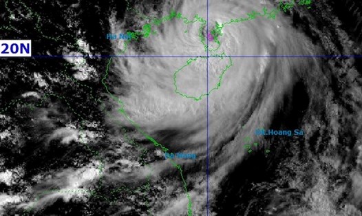
At 1:00 p.m. on October 6, the storm continued to move west-northwest at a speed of about 20 km/h, moving deep into the northern mountainous area and weakening to level 6, gusting to level 8.
By 01:00 on October 7, when reaching the mountainous areas of the Northwest, the storm will weaken into a low pressure area, with an intensity below level 6.
From the night of October 05 to noon on October 6, coastal areas from Quang Ninh to Hung Yen and Lang Son province will have winds gradually increasing to level 6-7, near the storm center level 8-10, gusting to level 11-12.
Strong winds can break branches, blow off roofs, causing significant damage. The deep inland area of the Northeast will have winds of level 4-5, some places will have winds of level 6, gusting to level 7-8.
From the night of October 05 to the end of the night of October 17, the mountainous and midland areas of the North will have heavy rain, with common rainfall of 150-250 mm, some places over 400 mm. Warning of heavy rain concentrated in some places with an intensity of over 150 mm for 3 hours.
The Northern Delta and Thanh Hoa will have moderate to heavy rain, with common rainfall of 70-150 mm, locally over 200 mm.
In Hanoi, there is little chance of being directly affected by storms, but beware of thunderstorms, tornadoes and strong gusts of wind. From early morning of October 6 to the end of October 7, this area will have moderate to heavy rain, with common rainfall of 70-120 mm, locally over 150 mm.
Hainan province, which is on the path of the typhoon in China, has canceled flights, suspended all public transport and temporarily suspended many businesses to respond before the typhoon makes landfall.
On the morning of October 5, the National Meteorological Center of China said that Typhoon Matmo had strengthened with maximum sustained winds of about 151 km/h. The agency has issued a red alert - the highest level in China's warning system.
Chinese authorities have evacuated 150,000 people in Guangdong province, where southwestern regions are expected to be directly affected. In Hainan province, flights have been canceled, public transport and many business activities have stopped operating since October 4 to avoid the storm.
The China Meteorological Administration warned of heavy rain with rainfall reaching 100 - 249 mm in some areas, accompanied by strong winds and local flooding.
After making landfall in China, Typhoon Matmo is forecast to continue moving west and northwest, towards the mountainous areas of Northern Vietnam and Yunnan province (China).
Due to the wide circulation of the storm, there is a risk of thunderstorms, whirlwinds and strong gusts of wind before, during and after the storm makes landfall.
During the time when Typhoon Matmo affects the Northern and North Central regions, visitors need to closely monitor weather forecasts and proactively adjust travel schedules to ensure safety.
Limit going out to sea, visiting islands, coastal areas or participating in outdoor activities when the weather is bad.