
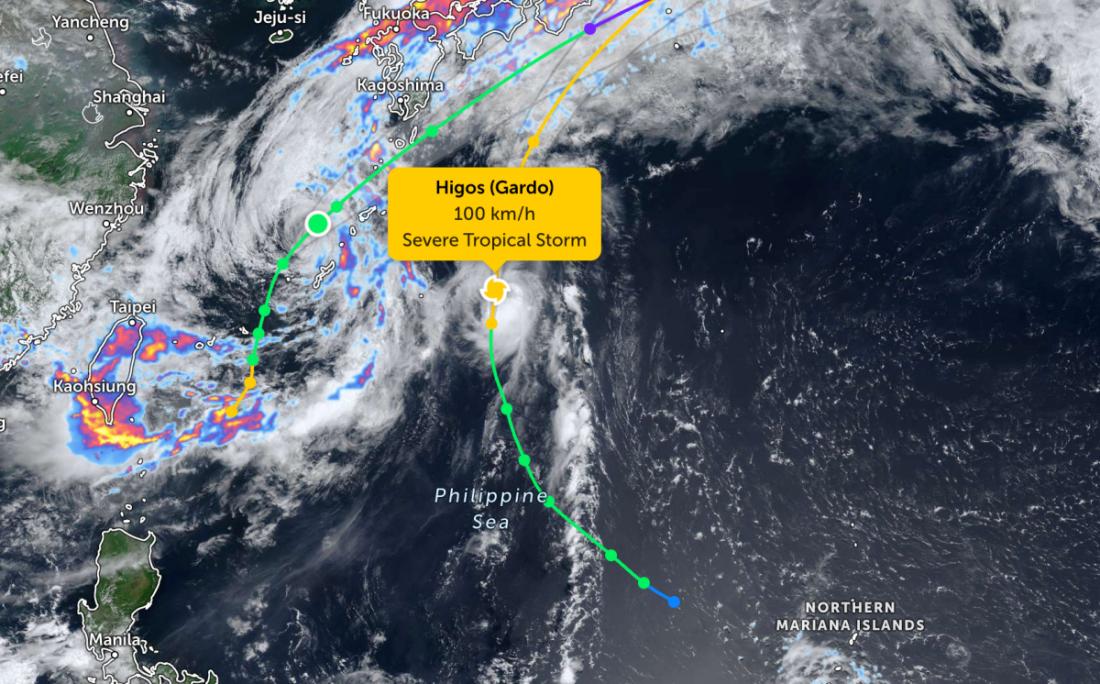
According to storm news, the latest low pressure from the Philippine Atmospheric, Geophysical and Astronomical Services Administration (PAGASA), Typhoon Higos is continuing to strengthen as it moves north-northwest over the Philippine Sea.
As of 4 am this morning, the storm's center was located at about 22.8 degrees North latitude - 134.1 degrees East longitude, about 1,280 km east-northeast of the northernmost point of Luzon Island. The strongest wind near the storm's center reached 95 km/h, gusting up to 115 km/h. The storm is moving in a North-Northwest direction at a speed of 25 km/h.
The storm circulation creates a storm-level strong wind area with a radius of about 260 km from the center.
Meanwhile, Typhoon Mekkhala has weakened to tropical storm level, with maximum winds reaching 75 km/h.
Currently, no storm warning signals have been sent in the Philippines because the storm is still very far from the mainland.
However, the Southwest monsoon continues to cause strong gusts to strong gusts on most of Luzon Island on June 26. On June 27, strong winds will affect Batanes, Babuyan Islands and Ilocos Norte and Ilocos Sur provinces.
At sea, the coastal area of Batanes has waves up to 3m high, rough seas. Many other sea areas have waves from 2-2.5m high. The meteorological agency recommends that small boats and vehicles that are not strong enough to withstand waves and winds should not go out to sea.
In the East Sea, according to the National Center for Hydro-Meteorological Forecasting, on the day and night of June 26, most sea areas will have scattered showers and thunderstorms, during thunderstorms there is a risk of tornadoes and strong gusts of wind at level 6-7.
The wind is mainly Southwest at level 4-5, especially the sea area from Gia Lai to Khanh Hoa, from Lam Dong to Ca Mau and the west of the Southern East Sea, Truong Sa special zone at times level 6, gusts level 7-8, rough seas. Sea waves are common from 1-2.5 m, especially the sea area from Gia Lai to Khanh Hoa is 2-3 m high; in rainstorms, waves can be over 2.5 m high. The Gulf of Thailand has West to Southwest winds at level 3-4, waves 0.5-1.5 m high.
People and tourists planning to visit these sea areas should closely monitor weather forecasts and follow local instructions to avoid dangerous storms and floods throughout the journey.


