According to storm and low pressure news from the Philippine Atmospheric, Geophysical and Astronomical Services Administration (PAGASA), Typhoon Mekkhala is still active in Philippine waters.
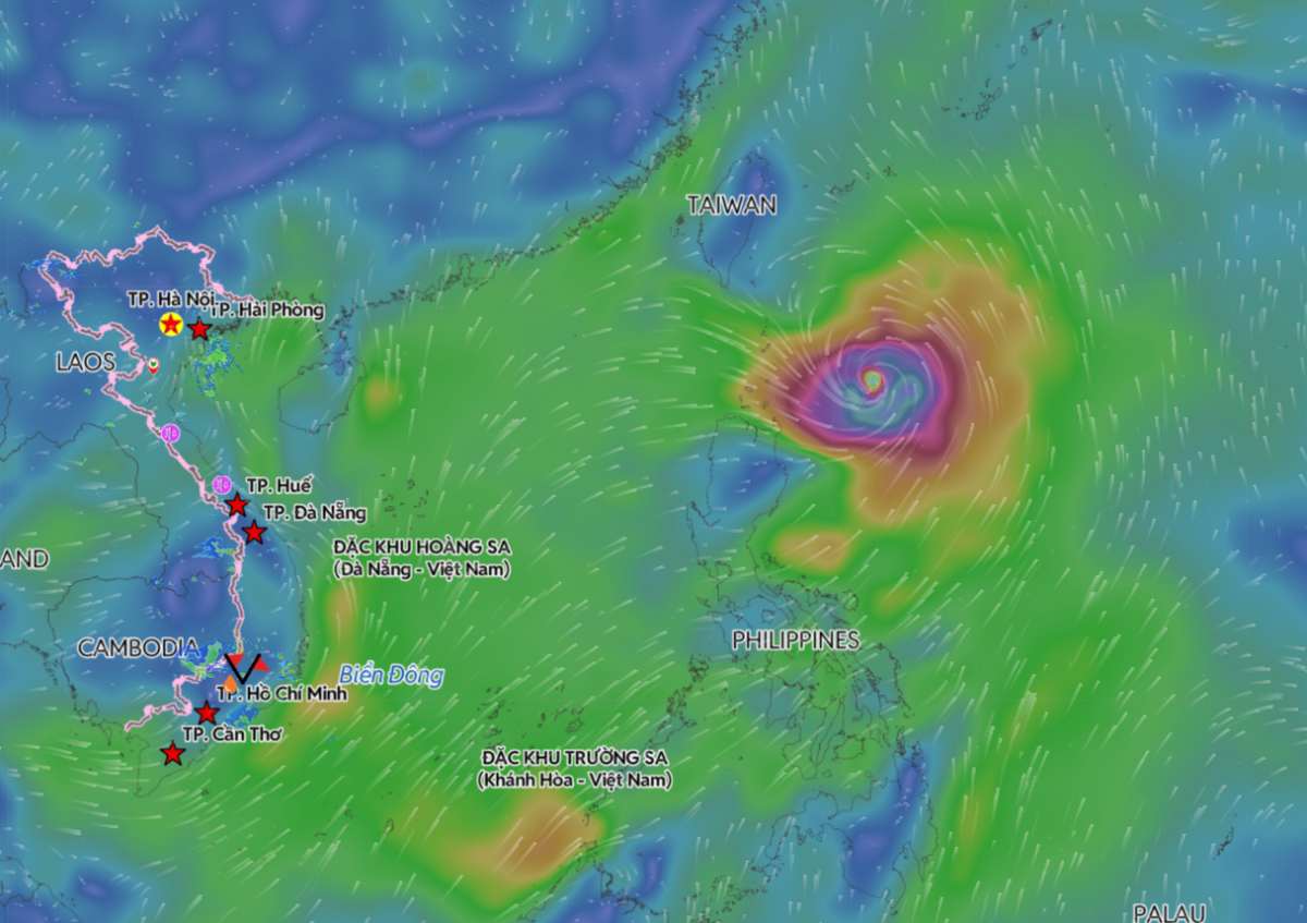
As of 2 pm today (local time), the storm's center is located at about 19.2 degrees North latitude - 124.7 degrees East longitude, about 340km northeast of Aparri, Cagayan province. The storm has maximum sustained winds of 175km/h, gusts up to 215km/h, central pressure 940 hPa.
The storm is moving in a Northwest direction at a speed of 10km/h. The storm's strong wind area extends to about 360km from the center.
Although not forecast to make landfall in the Philippines, the wide circulation of Mekkhala combined with the Southwest monsoon still caused widespread rain and strong winds in many areas.
According to PAGASA, from now until noon on June 24, Batanes and Cagayan provinces may record rainfall from 50-100mm. Heavy rain is at risk of causing localized flooding in urban areas, low-lying areas and riverside areas, and increasing the risk of landslides in hilly areas with critical geology.
Under the impact of the strengthened Southwest monsoon, Palawan, Occidental Mindoro and Antique are also forecast to have rainfall from 50-100mm on June 24. In the period from noon on June 24 to noon on June 25 and from noon on June 25 to noon on June 26, rain of the same intensity continues to be maintained in Palawan and Occidental Mindoro, and expands to Bataan province.
PAGASA warns that although no rain areas over 100mm have appeared in the current forecast, rainfall from 50-100mm lasting many days can still cause localized flooding, especially in urban areas, low-lying areas and riversides. The risk of landslides is also present in localities with steep terrain or saturated soil.
Currently, wind warning signal No. 1 is being applied to Batanes and the Northeast of Cagayan province, including part of the Babuyan archipelago. These localities may experience strong winds from 39-61km/h in the next 36 hours.
In addition, the southwest monsoon strengthening along with the outer circulation of the storm is causing strong gusts in most of the Luzon, Visayas and some localities in Mindanao.
At sea, strong wind warnings have been issued for the northern and northeastern Luzon waters. Sea waves up to 4.5m high appeared in the waters east of Batanes, Babuyan Islands and Northeast Cagayan, posing a danger to all types of ships.
According to forecasts, Typhoon Mekkhala will continue to move slowly in a North-Northwest direction until the morning of June 24 before changing direction to the Northeast towards Japan's Ryukyu Islands and the southern waters of this country. The typhoon is expected to leave the Philippine forecast area on the evening of June 25 or the morning of June 26.
PAGASA believes that Typhoon Mekkhala will maintain strong typhoon intensity in the short term before gradually weakening due to less favorable environmental conditions. However, during its time within the Philippine Responsibility Area, Mekkhala is still forecast to maintain typhoon intensity and continue to affect the weather in a large area.
People and tourists planning to travel to the northern Philippines or where the storm passes should pay attention to weather forecasts. Check flight schedules and follow local instructions to avoid dangerous storms throughout the journey.


