According to the latest typhoon news from the Japan Meteorological Agency (JMA), on the morning of June 1st, Typhoon Jangmi continued to move northward, then gradually shifted to the Northeast towards Okinawa Island of Japan.
The storm is forecast to enter Okinawa Island and the Amami Islands on June 1st and 2nd before directly affecting the western and eastern regions of Japan on June 3rd.
JMA said a near-static weather band exists in the north of the storm, causing widespread heavy rain to occur even before the eye of the storm approaches.
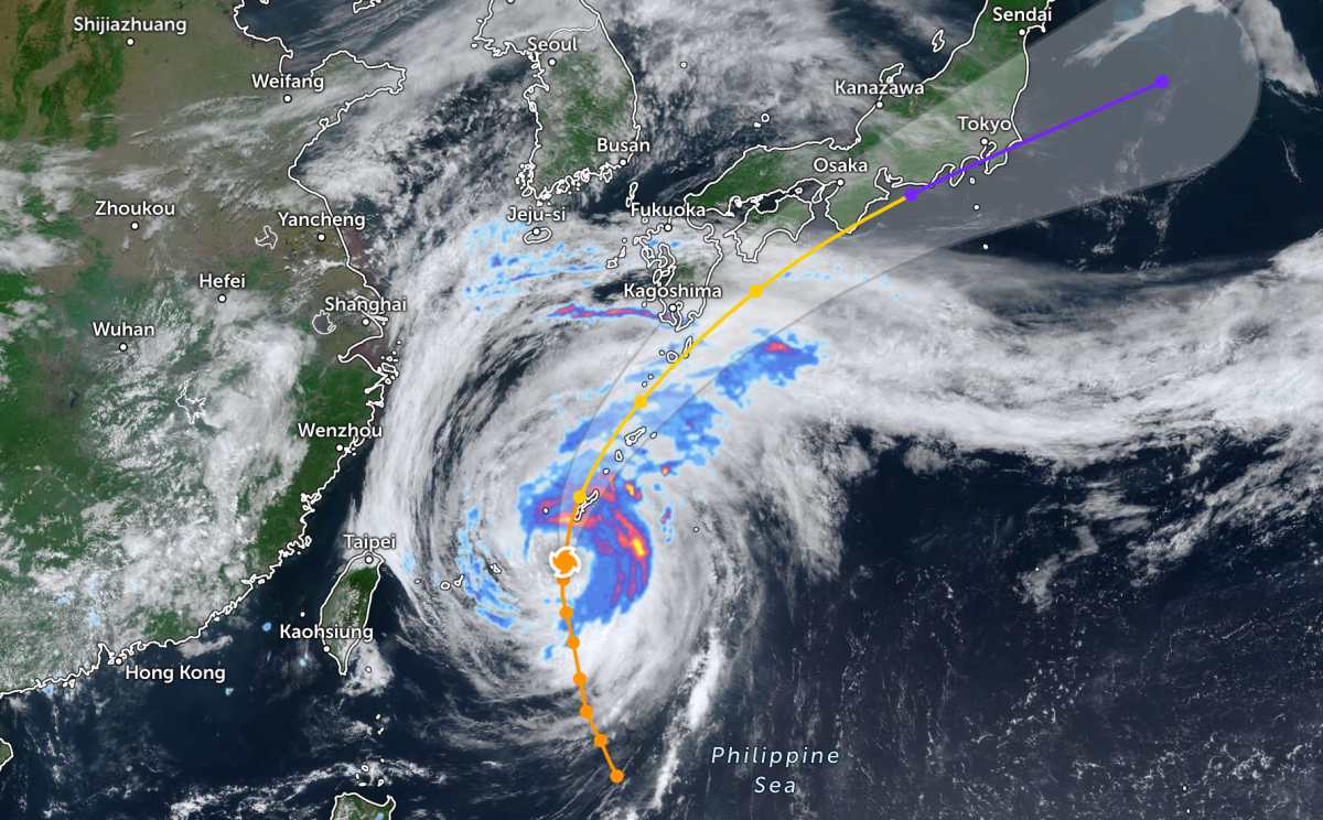
From Kyushu Island in the Southwest to Kanto region (where Tokyo is the capital), many localities are warned of the risk of prolonged heavy rain, accompanied by strong winds, high waves, rising sea levels, landslides, flash floods and flooding in low-lying areas.
In the 24 hours up to noon on June 1st, rainfall in Okinawa is forecast to reach about 100 mm, while the Amami area and the south of Kyushu Island may record about 80 mm. By noon on June 2nd, accumulated rainfall in some places may reach 300 mm.
On June 3rd, the Shikoku and Kansai areas in western Japan are forecast to continue to receive about 300 mm of rain. Meanwhile, the Tokai and Kanto areas may record rainfall of about 200 mm.
Faced with the complicated developments of the storm, two major Japanese airlines, Japan Airlines and All Nippon Airways, have announced the cancellation of a series of flights to and from Okinawa to ensure safety.
Meanwhile, the Philippine Atmospheric, Geophysical and Astronomical Services Administration (PAGASA) said that Typhoon Jangmi (local name Domeng) is currently slowing down in speed but still maintaining strong intensity.
On the morning of June 1st, the storm center was located about 655 km east-northeast of Itbayat Island in Batanes province. The strongest wind near the storm center reached 130 km/h, gusts up to 160 km/h.
According to PAGASA, the strong wind area from tropical storm to typhoon level is expanding within a radius of about 500 km from the storm center. The latest forecast shows that Jangmi will continue to move north and then northeast, gradually moving towards southern Japan.
The Philippine meteorological agency believes that Jangmi has likely reached maximum intensity and will begin to weaken after passing through the Okinawa area. With the current trajectory, the storm is moving far northeast of the East Sea, so it is unlikely to directly affect mainland Vietnam in the coming days.
In the East Sea, according to the National Center for Hydro-Meteorological Forecasting, on the morning of June 1st, a low pressure trough with axis at about 10-12 degrees North latitude connected to the low pressure area at 01:00 was located at about 11.5-12.5 degrees North latitude and 111.5-112.5 degrees East longitude.
The southern sea area of the Central East Sea, the South East Sea area (including Truong Sa special zone), the sea area from Gia Lai to Ca Mau, Ca Mau to An Giang and the Gulf of Thailand have scattered showers and thunderstorms.
Forecast for the day and night of June 1st, the Central and Southern East Sea area (including Truong Sa special zone), the sea area from Quang Ngai to Ca Mau, Ca Mau to An Giang and the Gulf of Thailand will have showers and thunderstorms. In thunderstorms, there is a possibility of tornadoes, strong gusts of wind at level 6-7 and waves over 2.0m high.
The western sea area of the South China Sea (including the western Truong Sa special zone) and the sea area from Lam Dong to Ca Mau have strong southwest winds of level 5, sometimes level 6, gusts of level 7-8. Seas are rough. Sea waves are 1.5-2.5m high.
All ships operating in the above areas are at risk of being affected by tornadoes, strong gusts of wind and high sea waves.
People and tourists planning to visit these sea areas and where Typhoon Jangmi passes should pay attention to weather forecasts. Regularly check flight schedules and follow local instructions to avoid storms affecting the journey.


