According to storm news, the latest low pressure from the Philippine Atmospheric, Geophysical and Astronomical Services Administration (PAGASA), Typhoon Jangmi (local name Domeng) continues to strengthen as it moves northwest over the sea area northeast of Luzon.
At 10 am this morning, the storm's center was located at about 17.7 degrees North latitude - 130.0 degrees East longitude, about 875 km east of Northern Luzon. The strongest wind near the storm's center reached 100 km/h, gusting to 125 km/h.
The storm is moving in a Northwest direction at a speed of about 20 km/h. The storm's strong wind circulation extends within a radius of about 500 km from the center.
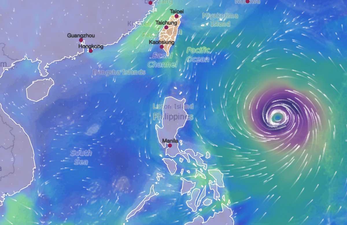
PAGASA forecasts that Typhoon Jangmi will continue to intensify and is likely to strengthen into a super typhoon on the night of May 30 or morning of May 31, while still operating in the sea area east of the Philippines.
After that, the storm is forecast to change direction, move towards southern Japan in the coming days and is unlikely to make landfall in the Philippines. The storm may leave the Philippine area of responsibility on June 1.
Although not forecast to make direct landfall, the typhoon's circulation combined with the Southwest monsoon is increasing heavy rain in many areas of the Philippines. PAGASA warns that the intensified Southwest winds may cause moderate to heavy rain in the western provinces of this country from late May to early June.
In addition to heavy rain, many areas in Luzon, Visayas and some localities in the southern Philippines are warned of strong winds to gusts due to the impact of storms and strengthened southwest monsoons.
At sea, the sea area east of the Batanes and Babuyan archipelagoes has waves up to 3.5 m high. The coastal area east of Cagayan, Isabela provinces and north of Aurora has waves from 3-3.5 m high. Many other sea areas record waves from 2-2.5 m high, causing danger to small boats.
In the East Sea, according to the National Center for Hydro-Meteorological Forecasting, on the morning of May 30, the sea area east of the Central East Sea, the South East Sea area (including Truong Sa special zone), the sea area from Khanh Hoa to Ca Mau, Ca Mau to An Giang and the Gulf of Thailand had showers and thunderstorms.
Forecast for the day and night of May 30, the Central and Southern East Sea area (including Truong Sa special zone), the sea area from Gia Lai to Ca Mau, Ca Mau to An Giang and the Gulf of Thailand will have showers and thunderstorms. In thunderstorms, there is a possibility of tornadoes, strong gusts of wind above level 6-7 and waves over 2.0m high.
All ships operating in the above areas are at risk of being affected by tornadoes, strong gusts of wind and high sea waves.
People and tourists should limit going to sea in areas with strong rough seas, and closely monitor the next developments of Typhoon Jangmi, to avoid causing danger from storms at sea.


