According to the latest storm news from the Joint Typhoon Warning Center (JTWC), strong tropical storm Jenna is currently located about 450 km south-southwest of the Cocos Islands (Australia).
The Australian Meteorological Agency (BOM) recorded the strongest winds near the center at about 150 km/h, gusts up to 205 km/h.
In the past 6 hours, the storm moved in a Southwest direction at a speed of about 15 km/h. The highest sea waves reached about 8.5 m, rough seas, posing high risks for maritime activities and marine tourism.
Weather forecast for January 7, Typhoon Jenna is forecast to continue moving southwest, along the northwest edge of the subtropical high pressure trough.
Then the storm is likely to shift westward, continuing to move along the northern edge of the subtropical high pressure in the following days.
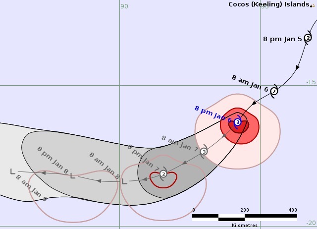
The storm will weaken rapidly in the next 2 days, with winds decreasing to about 75 km/h. The storm may weaken into a tropical depression around 8-9.1 when it enters the mid-Indochinese sea.
Forecast models are currently highly consensual on both the trajectory and intensity trend of Hurricane Jenna, showing relatively good reliability for the scenario of the storm moving further away and gradually weakening, with little likelihood of directly impacting the mainland.
However, tourists who are or plan to travel in the Cocos Islands and adjacent sea areas need to closely monitor weather forecasts and storm forecasts.
Limit activities at sea, especially yachts, diving, offshore fishing when waves are high and the sea is rough.
Always comply with safety recommendations from meteorological agencies and local authorities.


