Typhoon Nakri suddenly changes direction, following storm Halong to intensify

Vân Yên |

Typhoon Nakri off the coast of Japan is moving northwest at a speed of about 26 km/h. The path is quite similar to Typhoon Halong.

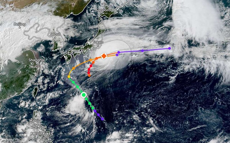
According to the latest storm information from the Joint Typhoon Warning Center (JTWC), Typhoon Nakri is having winds of about 65km/h, maximum gusts of 80km/h, moving near Yakushima Island, southern Japan.

Tropical Storm Nakri continues to move northwest, forecast to move more than 320 km northeast of Okinawa Island (Japan) on Friday evening, October 10, maintaining its intensity at the weak tropical storm level.

Okinawa is not expected to be directly affected by strong typhoons. The strongest wind on the island could reach about 56 km/h, gusting to 84 km/h at around 7pm today (local time).

In the coming days, Nakri is expected to continue moving northwest before starting to turn northeast in the next 12 - 36 hours.

During this period, the storm may strengthen slightly.

The storm is forecast to reach its peak around the morning of October 13, with maximum winds of up to 150km/h.

After changing course, Nakri will accelerate northeast over the next 2 days, then turn east-northeast.

The storm is forecast to temporarily strengthen and reach its peak for about 3 more days before weakening into a tropical depression.

Recommendations for tourists

Closely monitor local weather reports and from official meteorological agencies.

Plan flexibly for trips to Okinawa, Ryukyu Islands and coastal areas of Japan in the coming days.

Consider adjusting the sea or air travel schedule as the storm moves northeast.

Khuyen cao danh cho nguoi dan va du khach tai vung chiu anh huong cua bao. Anh: Tuong Van
Recommendations for people and tourists in areas affected by the storm. Photo: Tuong Van
Vân Yên
TIN LIÊN QUAN

Tropical depression officially becomes storm Nakri, following storm Halong

|

The tropical depression near the East Sea has officially strengthened into Typhoon Nakri, while Typhoon Halong is still active with winds of 205km/h.

Storm Halong is extremely strong as it approaches land, with strong winds of 252 km/h

|

Typhoon Halong is forecast to approach the mainland of the Izu island chain in southern Tokyo (Japan), with strong gusts of wind, strong waves and scattered showers.

Shops and hotels in Ha Giang suffered great damage after storms and floods

|

Storm No. 11 Matmo caused serious flooding in Tuyen Quang province. Many service and tourism businesses in Ha Giang 1 and Ha Giang 2 wards suffered heavy damage.

Tropical depression officially becomes storm Nakri, following storm Halong

Chí Long |

The tropical depression near the East Sea has officially strengthened into Typhoon Nakri, while Typhoon Halong is still active with winds of 205km/h.

Storm Halong is extremely strong as it approaches land, with strong winds of 252 km/h

Chí Long |

Typhoon Halong is forecast to approach the mainland of the Izu island chain in southern Tokyo (Japan), with strong gusts of wind, strong waves and scattered showers.

Shops and hotels in Ha Giang suffered great damage after storms and floods

Lam Hải |

Storm No. 11 Matmo caused serious flooding in Tuyen Quang province. Many service and tourism businesses in Ha Giang 1 and Ha Giang 2 wards suffered heavy damage.