Tropical depression officially becomes storm Nakri, following storm Halong

Chí Long |

The tropical depression near the East Sea has officially strengthened into Typhoon Nakri, while Typhoon Halong is still active with winds of 205km/h.

According to the latest storm information from the Philippine Atmospheric, Geophysical and Astronomical Services Administration (PAGASA), this morning, October 9, Typhoon NAKRI entered the Philippine Area of Responsibility (PAR).

As of 11am (local time), the center of Typhoon NAKRI was at about 21.9 degrees North latitude - 136.3 degrees East longitude, about 1,415 km east of the northernmost tip of Luzon.

The only wind near the center of the storm reached 75 km/h, gusting to 90 km/h. The storm is moving north-northwest at a speed of 25 km/h.

Cap nhat huong di cua bao Narki tren bien. Anh: JWTC
Update on the path of Typhoon Nakri at sea. Photo: JWTC

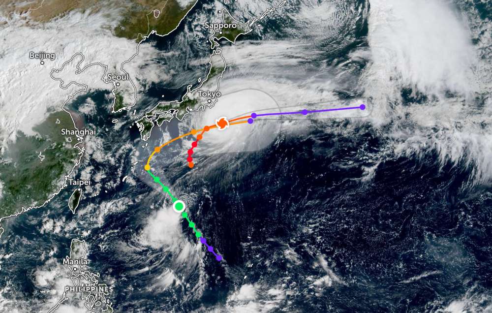
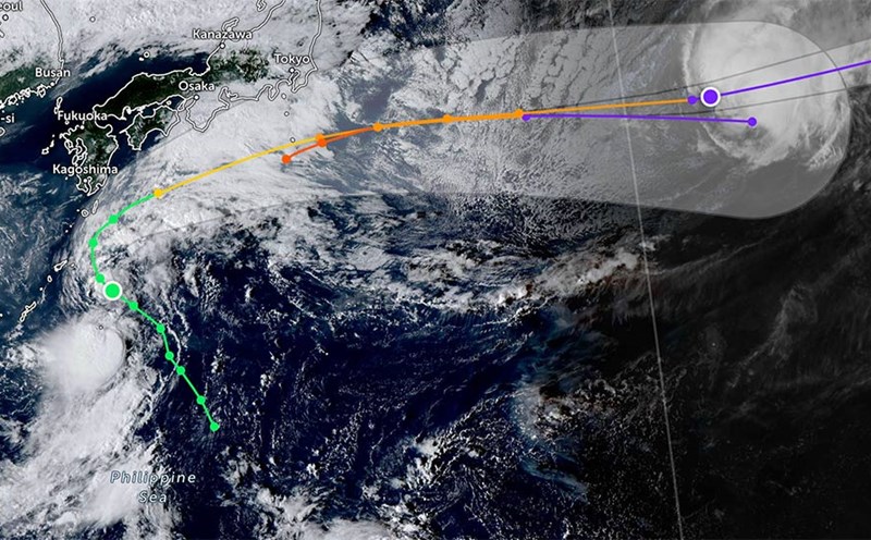
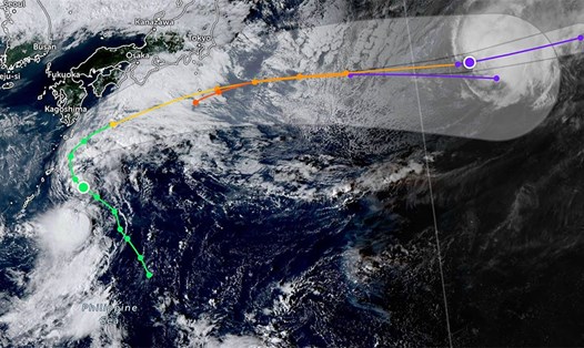
Meanwhile, Halong has gradually weakened into a strong typhoon. The center of the storm is located 287 km south of Yokosuka, Japan. The storm is moving northeast at a speed of 28 km/h.

The strongest wind near the center of the storm reached 195km/h, the maximum significant wave height was 11.9m.

According to the weather forecast from the National Center for Hydro-Meteorological Forecasting, on the morning of October 9, the Central and South East Sea (including Truong Sa special zone), the sea area from Quang Ngai to Ca Mau, from Ca Mau to An Giang and the Gulf of Thailand are having showers and thunderstorms.

Forecast for the day and night of October 9, the Central and South East Sea (including Truong Sa special zone), the sea area from South Quang Tri to Ca Mau, Ca Mau to An Giang and the Gulf of Thailand will have showers and thunderstorms. During thunderstorms, there is a possibility of tornadoes, strong gusts of wind of level 6-7, and waves over 2.0m high.

All ships operating in the above areas are at risk of being affected by tornadoes and strong gusts of wind.

People and tourists planning to visit these coastal areas should pay attention to weather forecasts. Tuan follows local instructions to ensure safety.

Chí Long
TIN LIÊN QUAN

Weather forecast for tomorrow, October 11: New low pressure in the East Sea has heavy thunderstorms

|

Weather forecast for tomorrow, October 11, the low pressure in the East Sea will continue to cause heavy rain in the South Central and South regions. The North is flooded for a long time despite flooding on rivers.

Typhoon Nakri suddenly changes direction, following storm Halong to intensify

|

Typhoon Nakri off the coast of Japan is moving northwest at a speed of about 26 km/h. The path is quite similar to Typhoon Halong.

New low pressure approaches the mainland of the South Central region, heavy thunderstorms

|

A low pressure is forecast in the East Sea and has entered the sea areas of Lam Dong and Khanh Hoa provinces of our country.

Storm Halong is extremely strong as it approaches land, with strong winds of 252 km/h

|

Typhoon Halong is forecast to approach the mainland of the Izu island chain in southern Tokyo (Japan), with strong gusts of wind, strong waves and scattered showers.

Shops and hotels in Ha Giang suffered great damage after storms and floods

|

Storm No. 11 Matmo caused serious flooding in Tuyen Quang province. Many service and tourism businesses in Ha Giang 1 and Ha Giang 2 wards suffered heavy damage.

Weather forecast for tomorrow, October 11: New low pressure in the East Sea has heavy thunderstorms

Ninh Phương |

Weather forecast for tomorrow, October 11, the low pressure in the East Sea will continue to cause heavy rain in the South Central and South regions. The North is flooded for a long time despite flooding on rivers.

Typhoon Nakri suddenly changes direction, following storm Halong to intensify

Vân Yên |

Typhoon Nakri off the coast of Japan is moving northwest at a speed of about 26 km/h. The path is quite similar to Typhoon Halong.

New low pressure approaches the mainland of the South Central region, heavy thunderstorms

Chí Long |

A low pressure is forecast in the East Sea and has entered the sea areas of Lam Dong and Khanh Hoa provinces of our country.

Storm Halong is extremely strong as it approaches land, with strong winds of 252 km/h

Chí Long |

Typhoon Halong is forecast to approach the mainland of the Izu island chain in southern Tokyo (Japan), with strong gusts of wind, strong waves and scattered showers.

Shops and hotels in Ha Giang suffered great damage after storms and floods

Lam Hải |

Storm No. 11 Matmo caused serious flooding in Tuyen Quang province. Many service and tourism businesses in Ha Giang 1 and Ha Giang 2 wards suffered heavy damage.