In the storm forecast bulletin at 4:00 a.m. on July 13, the Philippine Atmospheric, Geophysical and Astronomical Services Administration (PAGASA) said that the center of the tropical storm was at about 25.4 degrees north latitude Nari, 142.4 degrees east longitude, 2,165 km northeast of the northernmost tip of Luzon, still outside the Philippine Forecast Area (PAR) and not directly affecting the country.
Hurricane Nari had maximum sustained winds of 65 km/h near the center and gusts of up to 80 km/h. The storm is moving northeast at a speed of 15 km/h and is not expected to enter PAR.
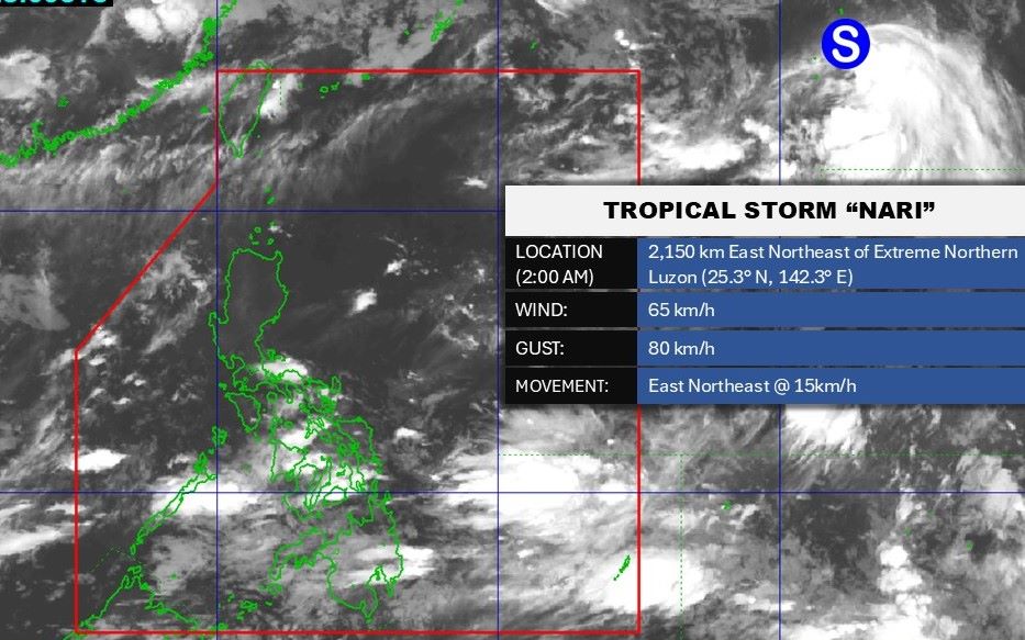
In the next few days, storm Nari is forecast to accelerate rapidly northward. As it moves deeper into the trough above the elevation, the wind shear will weaken, creating conditions for the storm to strengthen.
Typhoon Nari is expected to reach its peak intensity on July 14 as it approaches the east coast of Honshu Island (Japan). However, later, due to the combined impact of increased wind shear, the sea water gradually cools and interacts with the weather system ahead, the storm will quickly lose tropical features and become a post-tropical cyclone.
The cyclone will then turn strongly east-northeast as it moves around the edge of the high pressure system, and is likely to leave the West Pacific on July 17 when it approaches the Aleutian Islands (USA).
Meanwhile, PAGASA said it is monitoring a cloud cluster east of Mindanao that could develop into a low pressure area in the coming days.
Palawan will see scattered showers from the southwest monsoon, which could cause flash floods or landslides.
The weather forecast at 4:00 a.m. on July 13 of the Vietnam National Center for Hydro-Meteorological Forecasting said that in the Gulf of Tonkin and the southern sea area of the central East Sea, there will be showers and thunderstorms.
It is forecasted that on the day and night of July 13, there will be scattered showers and thunderstorms in the Gulf of Tonkin, the central and southern East Sea (including the Truong Sa special zone), the sea area from Lam Dong to Ca Mau, from Ca Mau to An Giang, the Gulf of Thailand
During thunderstorms, there is a possibility of tornadoes, strong gusts of wind, and waves over 2m high.
Regarding the forecast of rain, on the day and night of July 13, the Northern region will have scattered showers and thunderstorms, with some places having heavy rain. The common rainfall is 10-30mm, locally over 50mm.
In the afternoon and evening of July 13, scattered showers and thunderstorms in the Thanh Hoa - Nghe An area, Central Highlands. In the South, the common rainfall is 10-30mm, locally over 60mm.
Also according to the Vietnam National Center for Hydro-Meteorological Forecasting, in the next month, the East Sea area is likely to have the same number of storms or tropical depressions as the average of many years and may affect the mainland of Vietnam.
According to the average data of many years in the above period, there were 1.9 storms or tropical depressions in the East Sea, 0.9 of which made landfall.