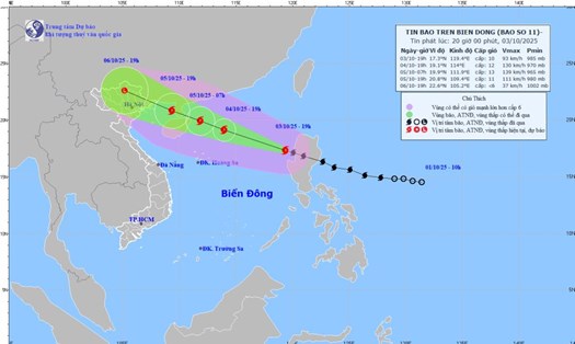
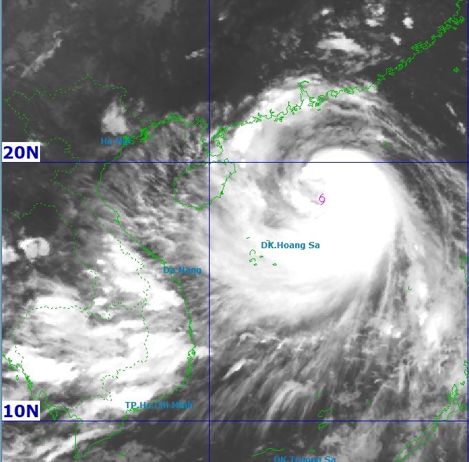
According to the latest weather forecast from the National Center for Hydro-Meteorological Forecasting, at 6:00 p.m. on October 4, the center of the storm was at about 18.7 degrees North latitude; 114.4 degrees East longitude, about 300km northeast of Hoang Sa Special Zone.
The strongest wind near the storm center is level 12 (118-133 km/h), gusting to level 15.
It is forecasted that in the next 3 hours, the storm will move in a West-Northwest direction, at a speed of about 25 km/h.
By the afternoon of October 5, storm No. 11 Matmo moved in a West-Northwest direction at a speed of 20-25km/h and was likely to strengthen. The center of the storm is located at about 20.7 degrees North latitude; 109.8 degrees East longitude, in the western area of the Lusi Peninsula (China), about 250km southeast of Quang Ninh. This is the second landfall after Typhoon Matmo swept through the Philippines a few days ago
Strong storm intensity level 12, gust level 15. The danger zone is located north of the 16.5th parallel north and from the 109.0 to 118.0 degrees east longitude. Natural disaster risk level 3, the affected area is the North East Sea.
From the afternoon of October 5, the sea area east of the North of the Gulf of Tonkin (including the Bach Long Vi special zone) will have winds gradually increasing to level 6-7, then increasing to level 8-9. From the evening of October 5, the North of the Gulf of Tonkin (including Bach Long Vi, Van Don, Co To, Cat Hai and Hon Dau island) will gradually increase to level 8-9, waves 2.0-4.0m high; the area near the storm's eye will have strong winds of level 10-11, gusts of level 14, waves 3.0-5.0m high; the sea will be rough, very dangerous for ships.
Coastal areas and islands in Quang Ninh - Hai Phong province will have storm surge of 0.4-0.6m high. Beware of flooding in low-lying coastal areas and river mouths from the afternoon and evening of October 5.
From the night of October 5, coastal areas from Quang Ninh to Hung Yen will gradually increase to level 6-7, near the storm's eye will have strong winds of level 8-9, gusting to level 10-11. The wind can break tree branches, blow off roofs and cause damage to structures and houses. The deep inland areas of the Northeast will have strong winds of level 4-5, some places will have level 6, gusting to level 7-8.
From the night of October 05 to the end of the night of October 17, the mountainous and midland areas of the North will have heavy rain, with common rainfall of 150-250mm, locally over 400mm. There is a risk of heavy rain over 150mm in 3 hours.
The Northern Delta and Thanh Hoa will have moderate rain, heavy rain with common rainfall of 70-150mm, locally over 200mm.
Hanoi is unlikely to be directly affected by storms. However, it is forecasted that from early morning of October 6 to the end of October 7, there will be moderate to heavy rain, with common rainfall of 70-120mm, locally over 150mm.
People and tourists should be cautious due to the risk of thunderstorms, tornadoes and strong gusts of wind both before and during the storm.
Detailed weather forecast for the night of October 4 and 5:
Hanoi
Lowest temperature: 24-26°C
Highest temperature: 32-34°C
Cloudy, no rain at night, sunny during the day; from tomorrow evening there will be showers and thunderstorms. Northwest to north wind level 2-3. During thunderstorms, there is a possibility of tornadoes, lightning and strong gusts of wind.
Northwest
Lowest temperature: 23-26°C, some places below 22°C
Highest temperature: 31-34°C
Cloudy, scattered showers and thunderstorms, sunny days. Light wind. During thunderstorms, there is a possibility of tornadoes, lightning and strong gusts of wind.
Northeast
Lowest temperature: 23-26°C, mountainous areas below 23°C
Highest temperature: 31-34°C
Cloudy, with showers and thunderstorms in some places, from the afternoon there will be scattered showers and thunderstorms, locally heavy rain in some places. Northwest to north wind level 2-3. During thunderstorms, there is a possibility of tornadoes, lightning and strong gusts of wind.
Thanh Hoa to Hue
Lowest temperature: 24-27°C
Highest temperature: 31-34°C
Cloudy, scattered showers and thunderstorms, sunny days. West to southwest wind level 2-3. During thunderstorms, there is a possibility of tornadoes, lightning and strong gusts of wind.
South Central Coast
Lowest temperature: 24-27°C
Highest temperature: 31-34°C
Cloudy, scattered showers and thunderstorms, sunny days. Southwest wind level 2-3. During thunderstorms, there is a possibility of tornadoes, lightning and strong gusts of wind.
Central Highlands
Lowest temperature: 19-22°C
Highest temperature: 29-32°C
Cloudy, with showers and thunderstorms in some places; in the late afternoon and evening, there will be scattered showers and thunderstorms, with some places having heavy rain. Southwest wind level 2-3. During thunderstorms, there is a possibility of tornadoes, lightning and strong gusts of wind.
Southern region
Lowest temperature: 24-27°C
Highest temperature: 31-34°C
Cloudy, with showers and thunderstorms in some places; in the late afternoon and evening, there will be scattered showers and thunderstorms, with some places having heavy rain. Southwest wind level 2-3. During thunderstorms, there is a possibility of tornadoes, lightning and strong gusts of wind.
Ho Chi Minh City
Lowest temperature: 24-26°C
Highest temperature: 32-34°C
Cloudy, with showers and thunderstorms in some places; in the late afternoon and evening, there will be scattered showers, with some places having heavy rain. Southwest wind level 2-3. During thunderstorms, there is a possibility of tornadoes, lightning and strong gusts of wind.