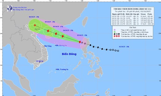
According to the latest storm news from the National Center for Hydro-Meteorological Forecasting, this morning, October 4, storm No. 11 Matmo was at about 18.1 degrees North latitude; 116.5 degrees East longitude, about 470km East Northeast of Hoang Sa Special Zone.
The strongest wind speed reaches level 11 (103-117km/h), gusting to level 14.
The storm is moving west-northwest at a speed of about 25km/h.
It is forecasted that by 7:00 a.m. on October 5, the storm will continue to maintain its speed and move west-northwest towards the northwest of the North East Sea, about 90km east of the Lusian Peninsula (China).
The intensity increases to level 13, gust level 16.
On the morning of October 6, the storm moved west-northwest at a speed of about 20 km/h, entering the northeastern sea of the Gulf of Tonkin and starting to weaken, with winds of level 8, gusting to level 10.
By the evening of the same day, the storm continued to move inland in the Northeast region of the North, gradually weakening into a tropical depression and then becoming a low pressure area in the Northern mountainous region.
Due to the impact of storm No. 11 Matmo, from the night of October 05 to the end of the night of October 17, in the Northern region, Thanh Hoa and Nghe An, there will be heavy to very heavy rain with common rainfall of 100-200mm, locally over 300mm.
In the mountainous and midland areas of the North, it is generally from 150-250mm, locally over 400mm. Warning of the risk of heavy rain (>200mm/3 hours).

The North East Sea area has strong winds of level 8-10, the area near the storm center has level 11-13, gusts of level 16, waves 4.0-6.0m high, the area near the storm center has 6.0 8.0m, the sea is very rough (extremely strong in destructive power, extremely strong waves, can sink ships with high weights).
From the afternoon of October 5, the sea area east of the North of the Gulf of Tonkin (including the Bach Long Vi special zone) will have winds gradually increasing to level 6-7, then increasing to level 8-9.
From the evening of October 5, the North of the Gulf of Tonkin (including the special areas of Bach Long Vy, Van Don, Co To, Cat Hai and Hon Dau island) will gradually increase to level 8-9, waves 2.0-4.0m high, the area near the storm's eye will have level 10-11, gusts of level 14, waves 3.0-5.0m high, rough seas (heavy seas, very dangerous for ships).
Coastal areas and islands in Quang Ninh - Hai Phong province will have storm surge of 0.4-0.6m high. Beware of flooding in low-lying coastal areas, river mouths due to rising water and big waves from the afternoon and evening of October 5.
From the night of October 5, on the mainland from Quang Ninh to Ninh Binh, the wind will gradually increase to level 6-7, near the storm's eye level 8-9. The wind broke tree branches and blew off the roofs, causing damage to houses. Can't go against the wind.
The deep inland area of the Northeast will have strong winds of level 5, some places will have level 6, gusting to level 7-8.
People and tourists in the North and North Central regions need to be cautious about the developments of storm No. 11 Matmo.
The weather at sea and in coastal areas during the storm is extremely dangerous and unsafe for any vehicles or works operating in the dangerous area such as tourist boats, passenger ships, transport ships, cages, rafts, aquaculture areas, dykes, embankments, coastal roads.
Vehicles are likely to overturn or be destroyed; flooded due to strong winds, large waves and rising sea levels.
Many localities in the North are recording flooding, landslides and local traffic disruption. Tourists should closely monitor weather reports and recommendations from local authorities.
Proactively adjust your route, avoid moving through mountainous areas, along rivers and streams or routes at risk of landslides. Some tourist destinations in the northern mountainous region such as Tuyen Quang, Lao Cai..., especially in remote areas, may have interrupted services or difficulty accessing during this time.