According to the latest storm information from the Joint Typhoon Warning Center (JTWC), Typhoon Wipha (called Crising in the Philippines, Typhoon No. 6 in Japanese localization and Typhoon No. 3 in Vietnam) is being monitored in the North East Sea area.
The maximum wave height recorded was 6.1 meters.
Wipha in Thai means royal or brilliant. It is forecasted that by the afternoon of July 19, the storm will strengthen into a severe tropical storm with sustained winds of 110km/h near the center and about 400km from Hong Kong City (China), according to the Hong Kong Meteorological Station.
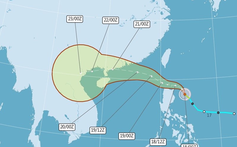
The JTWC forecasts that in the next 24 hours, Typhoon Wipha will continue to move west-northwest.
In the next 24 hours, the high pressure area will expand north of the center of the storm, the direction of the storm will shift more to the west, moving along the southern coast of China.
Typhoon Wipha will then change direction to the west-southwest for the remainder of the forecast period.
In the next 60 hours, the center of the storm is forecast to enter the Gulf of Tonkin and enter the Northern region of Vietnam in the next 3 days.
Typhoon No. 3 Wipha is forecast to strengthen in the next 24 hours as environmental conditions remain favorable.
However, as it approaches China's southern coast, terrain interaction will weaken the storm. A brief intensification period is forecast as the storm enters the Gulf of Tonkin, due to the very high sea surface temperature of about 31°C.
After making landfall in mainland Vietnam, Wipha will weaken rapidly and gradually dissipate around the 5th day of the forecast period.
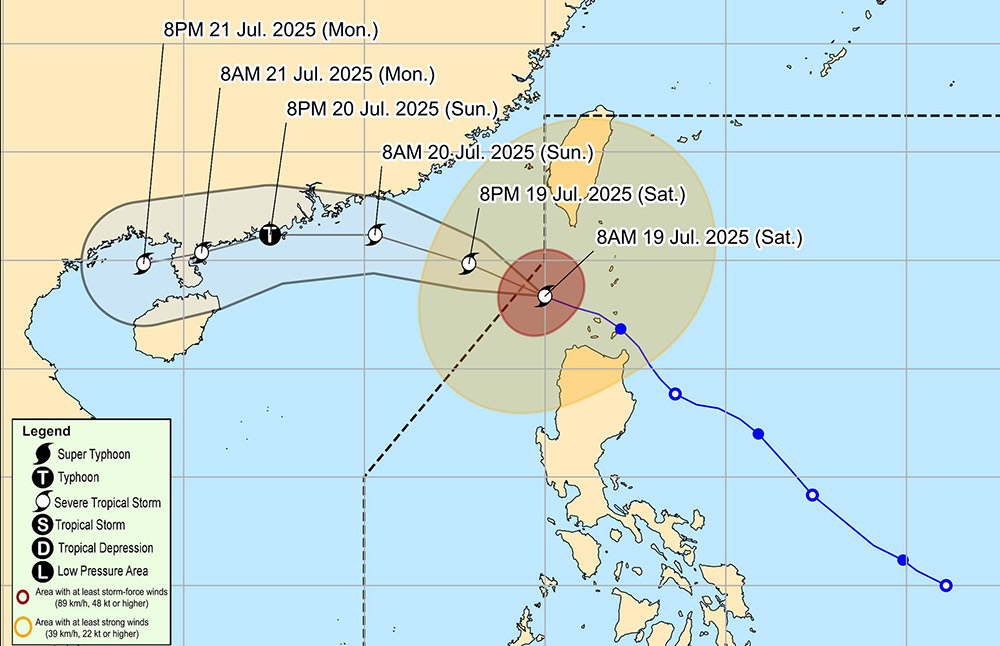
According to the storm information on the East Sea of the National Center for Hydro-Meteorological Forecasting, at 1:00 p.m. on July 19, the center of storm Wipha was at about 20.5 degrees North latitude - 119.0 degrees East longitude, in the northeastern sea area of the North East Sea.
The strongest wind near the storm center is level 9-10 (75-102km/h), gusting to level 12. The storm is moving northwest at a speed of about 20km/h.
By 1:00 p.m. on July 20, the storm will move west-northwest at a speed of 20-25km/h and is likely to strengthen.
The center of the storm will be at about 21.8 degrees North latitude - 113.7 degrees East longitude, in the northern sea area of the North East Sea, about 370km east of the Lusian Peninsula (China). At this time, the storm will be strong at level 11-12, gusting to level 15.
At 1:00 p.m. on July 21, the storm changed direction to the West Southwest, reducing its speed to 1520km/h. The center of the storm is located on the western coast of the Lusi Peninsula, at about 21.2 degrees North latitude - 109.6 degrees East longitude. The strongest wind is level 10-11, gusting to level 13.
At 1:00 p.m. on July 22, the storm continued to move in the West Southwest direction, at a speed of 10-15km/h and gradually weakened. The center of the storm will be on the mainland of the Northern Delta and Thanh Hoa, at about 20.5 degrees North latitude - 106.3 degrees East longitude.
In the coming hours, the northern area of the North East Sea will continue to have strong winds of level 8-10, near the storm center level 11-12, gusting to level 15. Waves are 4.0-6.0m high. The sea is rough.
Forecasts show that the storm will begin to weaken after the next 12 hours, when it approaches the Chinese coast.
Ship operating in the danger zone are at high risk of thunderstorms, tornadoes, strong winds and large waves. Northern coastal localities need to closely monitor the development of storms and proactively deploy appropriate natural disaster prevention measures.
People and tourists need to monitor weather reports to promptly update the latest information.
Tourists in the Southern and Southeast regions of China should pay attention to following local recommendations.
About 89 ferries on 24 routes in Guangdong were temporarily suspended due to the impact of Typhoon Wipha. In addition, the railway industry also applies a storm prevention emergency regime and may cause travel delays on many routes in Quang Dong province.
Northeast Asian airlines such as Asiana Airlines and EVA Air have all issued warnings of possible flight delays or cancellations due to the impact of Typhoon Wipha at airports in China such as Guangzhou, Shenzhen, Hong Kong, etc.