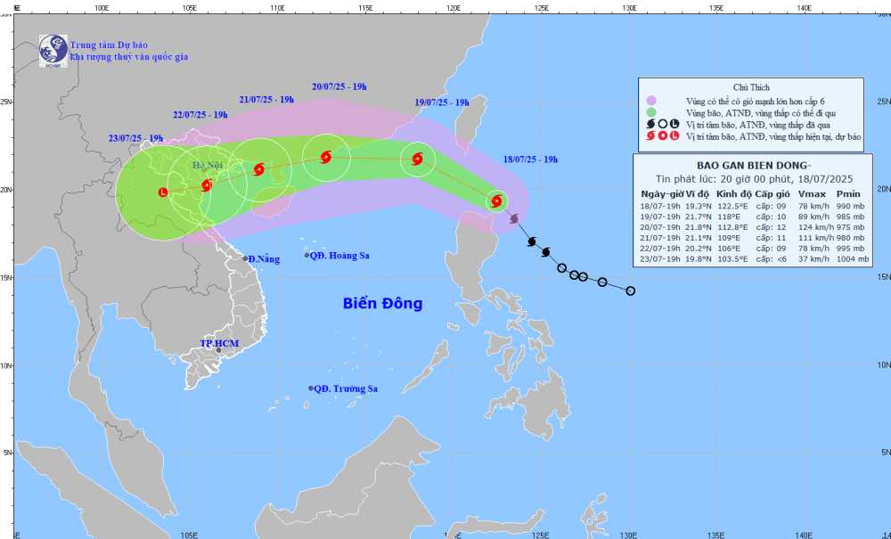
According to the latest storm information from the National Center for Hydro-Meteorological Forecasting, Typhoon Wipha will officially enter the East Sea area last night and early this morning, July 19, becoming the third storm to make landfall in this sea area during the 2025 typhoon season.
It is forecasted that by 1:00 p.m. on July 19, storm No. 3 will move in a West-Northwest direction at a speed of about 20-25 km/h, entering the East Sea and continuing to strengthen. The center of the storm is located at about 20.1 degrees North latitude - 119.0 degrees East longitude, in the northeastern sea area of the North East Sea.
The strongest wind near the storm center is level 10, gusting to level 12. The natural disaster risk level is level 3 for the eastern sea area of the North East Sea.
By 7:00 p.m. tonight, the storm will move west-northwest at a speed of 20-25 km/h, moving deeper into the East Sea and continuing to strengthen. The center of the storm is located at about 21.7 degrees North latitude - 118.0 degrees East longitude, in the northeastern sea of the North East Sea, about 850 km east of the Lusian Peninsula (China).
The strongest wind intensity near the storm center is level 10, gusting to level. Natural disaster risk level: level 3 for the eastern sea area of the North East Sea.
Due to the influence of the storm, thunderstorms will appear in the following areas: The eastern sea area of the North East Sea will have storms, the Central and South East Sea (including the special areas of Hoang Sa and Truong Sa, the sea area from Lam Dong to Ca Mau, the sea area from Ca Mau to An Giang and the Gulf of Thailand.
The sea area north of the North East Sea will have strong winds of level 7-8, the area near the storm's eye will have winds of level 10-12, gusts of level 14; waves 4.0-6.0m high; the sea will be very rough.
The sea area from Gia Lai to Ho Chi Minh City, the Central and South East Sea area (including Truong Sa special zone) will have strong southwest winds of level 6, sometimes level 7, gusting to level 8-9; waves 2.0-4.0m high; rough seas.
The sea area from southern Quang Tri to Quang Ngai will have strong southwest winds of level 5, sometimes level 6, gusting to level 7-8; waves 2.0-3.0m high; rough seas.
People and tourists coming to these coastal areas should pay attention to weather forecasts. Follow local recommendations to ensure safety.
On land, most areas will be cloudy with scattered showers and thunderstorms in some places, with scattered showers and thunderstorms in the afternoon and evening, with some places having heavy rain.
In the Northern region, it will be sunny during the day, with some places experiencing hot weather. Showers and thunderstorms appear in the evening.
Weather forecast for today, September 19:
City.Hanoi Lowest temperature: 29-31 degrees Celsius Highest temperature: 35-36 degrees Celsius, some places above 36 degrees Celsius Cloudy, no rain at night, hot sunny during the day, showers and thunderstorms in some places in the evening.
Light wind.
Northwest Lowest temperature: 26-29 degrees Celsius, Lai Chau, Dien Bien, Son La 23-25 degrees Celsius Highest temperature: 32-35 degrees Celsius, some places above 35 degrees Celsius Cloudy, scattered showers and thunderstorms at night, sunny during the day, hot in some places, scattered showers and thunderstorms in the evening, locally heavy rain in some places.
Light wind.During thunderstorms, there is a possibility of tornadoes, lightning, hail and strong gusts of wind.
Northeast Lowest temperature: 27-30 degrees Celsius Highest temperature: 34-36 degrees Celsius, some places above 36 degrees Celsius Cloudy, no rain at night, hot sunny during the day, scattered showers and thunderstorms in the evening, locally heavy rain in some places.
Light wind.During thunderstorms, there is a possibility of tornadoes, lightning, hail and strong gusts of wind.
Thanh Hoa to Hue Lowest temperature: 27-30 degrees Celsius Highest temperature: 35-37 degrees Celsius, some places above 37 degrees Celsius Cloudy, scattered showers and thunderstorms at night, hot sunny during the day, some places have severe heat, especially in the Thanh Hoa to Ha Tinh area in the evening there are scattered showers and thunderstorms.
Light wind.During thunderstorms, there is a possibility of tornadoes, lightning, hail and strong gusts of wind.
South Central Coast Lowest temperature: 27-30 degrees Celsius Highest temperature: 34-37 degrees Celsius, some places above 37 degrees Celsius Cloudy, showers and thunderstorms in the evening and at night, hot sunny during the day, some places are very hot.
Southwest wind level 2-3.During thunderstorms, there is a possibility of tornadoes, lightning, hail and strong gusts of wind.
Central Highlands Lowest temperature: 19-22 degrees Celsius Highest temperature: 27-30 degrees Celsius Cloudy, scattered showers and thunderstorms in some places, scattered showers and thunderstorms in the afternoon and evening, locally heavy rain in some places.
Southwest wind level 2-3.During thunderstorms, there is a possibility of tornadoes, lightning and strong gusts of wind.
Southern region Lowest temperature: 24-27 degrees Celsius Highest temperature: 30-33 degrees Celsius, some places above 33 degrees Celsius Cloudy, scattered showers and thunderstorms in some places, scattered showers and thunderstorms in the afternoon and evening, locally heavy rain in some places.
Southwest wind level 2-3.During thunderstorms, there is a possibility of tornadoes, lightning and strong gusts of wind.
Ho Chi Minh City Lowest temperature: 24-26 degrees Celsius Highest temperature: 30-32 degrees Celsius Cloudy, scattered showers and thunderstorms in some places, scattered showers and thunderstorms in the afternoon and evening, locally heavy rain in some places.Southwest wind level 2-3.
During thunderstorms, there is a possibility of tornadoes, lightning and strong gusts of wind.