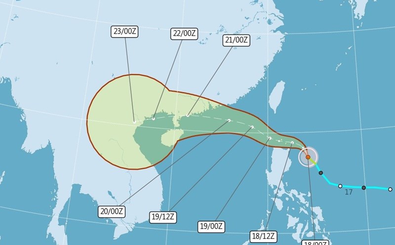
According to the latest weather forecast from the National Center for Hydro-Meteorological Forecasting, on the morning of July 19, Typhoon Wipha entered the northeastern sea of the North East Sea, becoming the third storm of 2025.
At 7:00 a.m., the center of the storm was at about 20.0 degrees North latitude - 119.8 degrees East longitude, in the northeastern sea area of the North East Sea. The strongest wind near the storm center is level 9 (75-88km/h), gusting to level 12. The storm is moving northwest at a speed of about 20km/h.
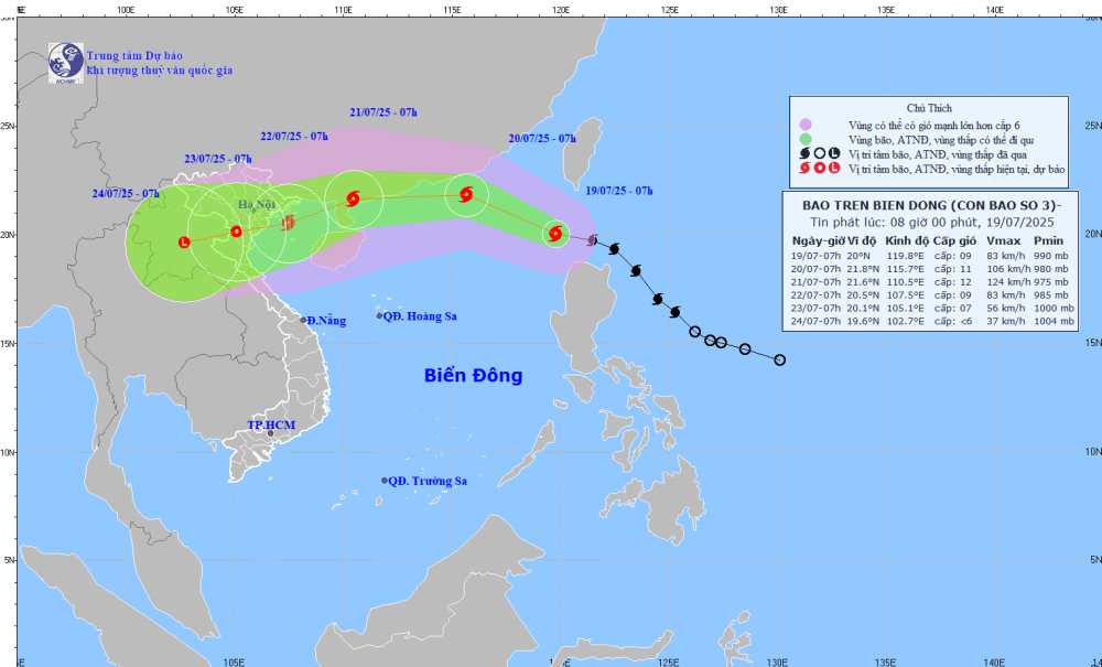
It is forecasted that by 7:00 a.m. on July 20, storm No. 3 will move in a West-Northwest direction at a speed of about 20 km/h, entering the East Sea and strengthening. The center of the storm is located at about 21.8 degrees North latitude - 115.7 degrees East longitude, in the northern sea area of the North East Sea; about 600 km east of the Lusi Peninsula (China).
The strongest wind near the storm center is level 10-11, gusting to level 13. Natural disaster risk level: level 3 for the eastern sea area of the North East Sea.
By 7:00 a.m. on July 21, the storm moved mainly west at a speed of about 20km/h. The center of the storm is located at about 21.6 degrees North latitude - 110.5 degrees East longitude, on the east coast of Zhou Peninsula (China).
The strongest wind near the storm center is level 11, gusting to level 14. Natural disaster risk level: level 3 for the northern sea area of the North East Sea, the eastern sea area of the Gulf of Tonkin.
From the next 72 to 120 hours, the storm will move mainly in the West Southwest direction, traveling 10-15km per hour and continuing to weaken.
Due to the influence of the storm, the sea area east of the North East Sea will gradually increase to level 6-7, the area near the center of the storm will have strong winds of level 8-9, then increase to 10-11, gusts of level2; waves 4.0-6.0m high. The sea is rough. Ship operating in the above-mentioned dangerous areas are likely to be affected by thunderstorms, whirlwinds, strong winds, and large waves.
People and tourists coming to Zhejiang Island, Hong Kong (China) and areas affected by Typhoon Wipha should pay attention to weather forecasts. Check flight schedules and follow local instructions to ensure safety.