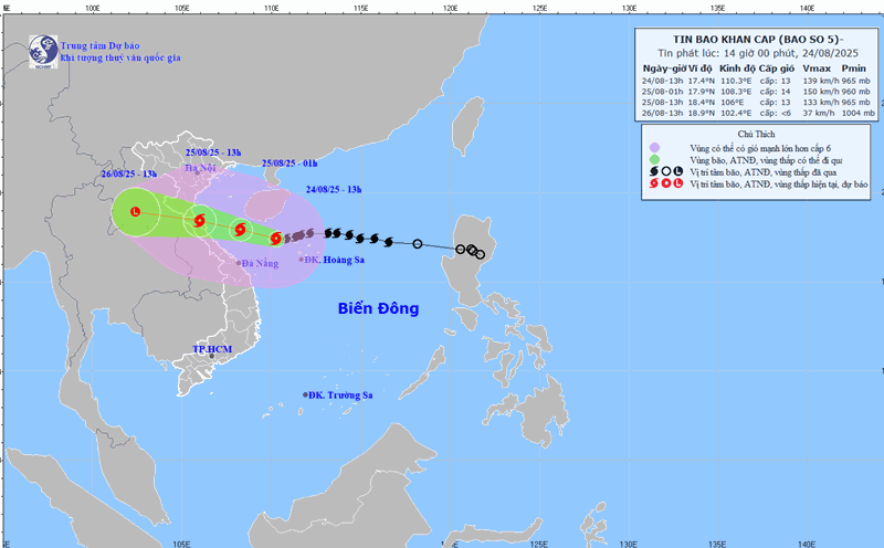
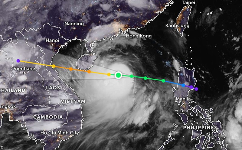
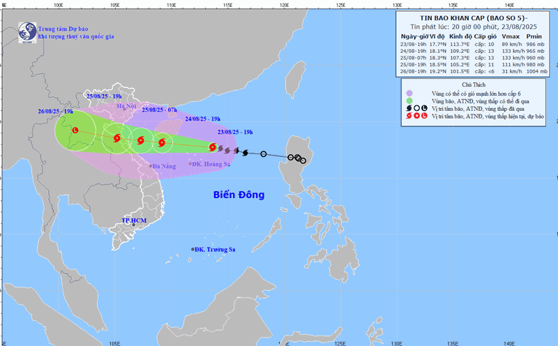
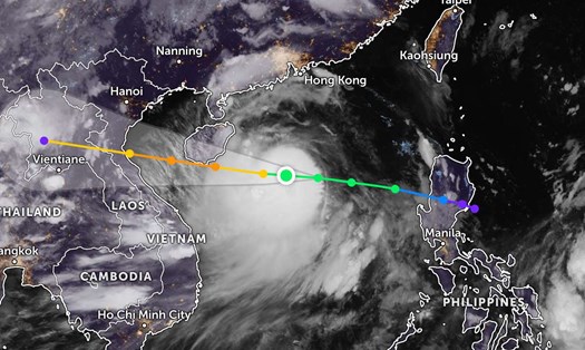
According to new storm news from the National Center for Hydro-Meteorological Forecasting, as of 7:00 a.m. on August 24, the center of the storm and Kajiki was at about 17.5 degrees North latitude - 111.4 degrees East longitude, in the northwest sea of the Hoang Sa archipelago, about 620 km from Nghe An, about 600 km east of Ha Tinh.
The strongest wind near the storm center is level 12 (118-133 km/h), gusting to level 15. Storm No. 5 is moving westward at a speed of about 20 km/h.
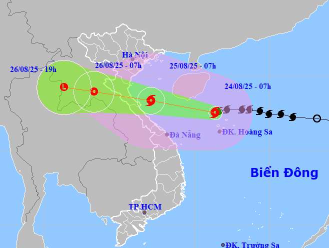
It is forecasted that by 7:00 a.m. on August 25, the center of the storm will be at 18.3 degrees North latitude-107.1 degrees East longitude, in the southern Gulf of Tonkin (about 160 km from Nghe An, about 140 km from Ha Tinh). Strong wind intensity level 12-13, gust level 15, and is likely to strengthen.
Storm No. 5 affected the northwest of the East Sea (including Hoang Sa), the Gulf of Tonkin, and the southern sea area of Quang Tri - Hue (including Hon Ngu, Con Co). Natural disaster risk level: level 3 at sea, level 4 at the coastal area of Thanh Hoa - Quang Tri.
By 7:00 p.m. on August 25, storm No. 5 moved in a West-Northwest direction at a speed of about 15-20km/h. The center of the storm is located at about 18.5 degrees North latitude - 105.2 degrees East longitude, on the mainland from Thanh Hoa to North Quang Tri.
The strongest wind near the storm center is level 11, gusting to level 13. Natural disaster risk level: level 3 for the Gulf of Tonkin, the southern sea area of Quang Tri-Hue city (including Hon Ngu island, Con Co special zone); level 4 for coastal waters from Thanh Hoa to Quang Tri, mainland provinces from Thanh Hoa to the north of Quang Tri.
Thus, storm No. 5 will make landfall in Vietnam tomorrow evening, August 25. At 7:00 a.m. on August 26, the storm moved west-northwest at a speed of 15-20 km/h, into Upper Laos. The center of the storm is located at about 18.9 degrees North latitude - 103.3 degrees East longitude. The wind intensity has decreased to level 6, gusting to level 8.
Due to the influence of storm No. 5, the northwestern sea area of the East Sea (including Hoang Sa) has strong winds of level 8-10, near the center of the storm level 11-13, gusts of level 15; waves 5-7m high, near the center 7-9m, the sea is very rough.
Area from Thanh Hoa - Hue (including Hon Ngu, Con Co): winds gradually increase to level 6-8, then increase to level 9-10, near the storm center level 11-13, gusts of level 15; waves 4-6m high, near the center 7-9m, the sea is very rough.
North of the Gulf of Tonkin (Cat Hai, Co To, Van Don): wind level 6-7, gust level 9; in the South (Bach Long Vi), wind level 8, gust level 10; waves 2-4m high, rough seas.
Coastal areas from Hai Phong to Ha Tinh, water level rose 0.5-1.5m. The expected water level in Hon Dau is 3.3-3.8m, Ba Lat is 1.7-2.1m, Sam Son is 3.2-3,5m, Hon Ngu is 3. 2-3-3.6m, Cua Nhuong is 2.2-2.000m. High risk of flooding in low-lying areas, coastal areas, river mouths in the evening of August 25.
On land, from the night of August 24, the area from Thanh Hoa - Quang Tri will have winds gradually increasing to level 7-9, near the storm center level 10-12, gusting to level 14-15. The coastal area of Quang Ninh - Ninh Binh has winds of level 6-7, gusting to level 8.
From August 24-26, the Northern Delta, South Phu Tho, Thanh Hoa - Hue will have heavy rain of 100-150mm, some places over 250mm. Thanh Hoa - Bac Quang Tri 200-400mm, some places more than 700mm. Risk of extremely heavy rain (more than 200mm/3 hours).
From August 25-26, in Hanoi and Da Nang, there will be moderate to heavy rain; Ho Chi Minh City will have thunderstorms in the evening.
People and tourists in the Northern and Central regions should pay attention to weather forecasts and update the direction of storm No. 5. Follow flight schedules and follow local instructions to avoid impactful storms.