A tropical depression moving off the coast of North Australia is assessed by meteorological agencies to be likely to strengthen and form a storm much earlier than the annual rainy and stormy season rule.
The tropical depression, temporarily known as 02U, is about 250 km northwest of Darwin and continues to move slowly east-northeast.
Atmospheric conditions and warmer-than-normal sea surface temperatures - up to more than 31 degrees Celsius - are creating a favorable environment for the tropical depression to develop into a storm.
According to the Australian Bureau of Meteorology (BoM), tropical depression 02U could reach tropical storm strength by Thursday afternoon or evening (20 November) and will then be named fina.
If this scenario happens, it will be one of the earliest storms to form in North Australia in more than a decade, nearly a month earlier than the time when the season usually recorded.
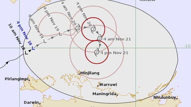
In the next two days, the tropical depression is forecast to change direction to the south and then southwest, approaching the Northern Territory coast.
Forecast models all show increased risks, although the path and intensity are still fluctuating. The chance of typhoon formation is estimated at 55-60% on Thursday (20.11, local time).
The BoM warns that the Tiwi Islands, Darwin and the northwest Top End could see heavy rain, strong winds and high waves.
For tourists in Northern Territory or preparing to travel to the Kimberley - Western Australia, it is necessary to continuously monitor local tropical depression forecasts and weather warnings.
It is important to prepare a backup plan, understand the evacuation route and update flight or ship schedules during this period of unstable weather.
Although the Australian typhoon season lasts from November to April, the actual number of storms making landfall is usually only about three to four.
However, experts say that early developments and high sea temperatures this year could make cyclone activity unusual.
Tropical Depression 02U has brought heavy rains to coastal areas, with Charles Point recording more than 220 mm in 24 hours - the highest level in 10 years.
The Joint Typhoon Warning Center (JTWC) forecasts that in the next 36 hours, the tropical depression will continue to move slowly.
The maximum intensity is forecast to be about 110 km/h in the next 36 hours, when favorable conditions will continue for the next 24 hours. The storm is likely to make landfall on the night of November 21 to November 22 before turning back out to sea on November 23.
Weather forecasts for the remaining Australian states are generally more stable, but North Australia will continue to be the focus of extreme weather for many of the coming days.
Tourists are advised to stay vigilant, monitor official updates from meteorological agencies and make flexible plans for the following days.


