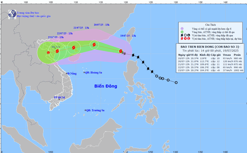
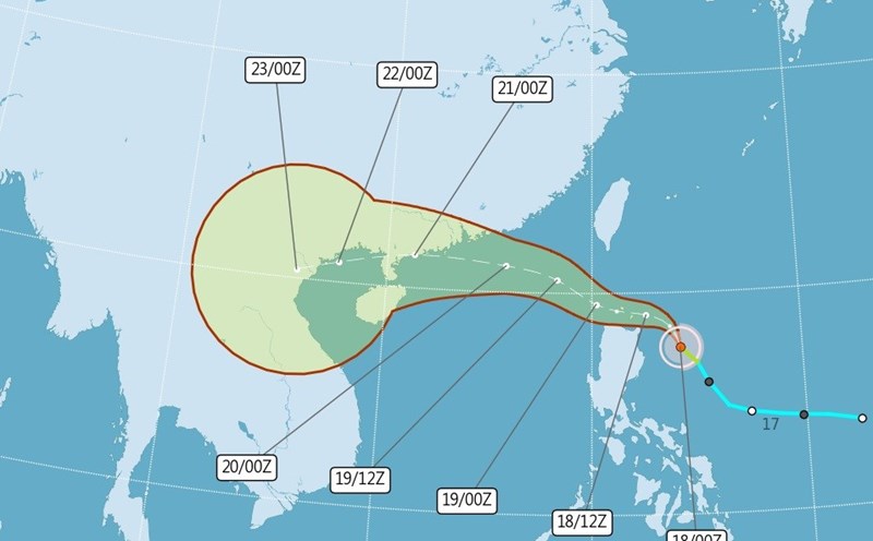
According to the National Center for Hydro-Meteorological Forecasting, at 4:00 p.m. on the afternoon of July 19, the center of storm No. 3 was at about 20.7 degrees North latitude - 118.4 degrees East longitude, in the northeastern sea area of the North East Sea.
The strongest wind near the storm center is level 10 (89-102km/h), gusting to level 12; moving in the West Northwest direction at a speed of about 20km/h.
It is forecasted that by 4:00 p.m. on July 20, the storm will move west-northwest at a speed of about 20-25 km/h and is likely to strengthen.
The center of the storm is located at about 21.7 degrees North latitude - 113.0 degrees East longitude, in the northern sea area of the North East Sea; about 370 km east of the Lusi Peninsula (China).
The strongest wind near the storm center is level 11, gusting to level 15. Natural disaster risk level: level 3 for the northern sea area of the North East Sea.
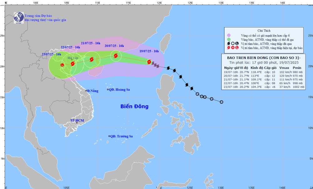
At 4:00 p.m. on July 21, the storm changed direction to the West Southwest, at a speed of about 15-20km/h. The center of the storm is located at about 21.1 degrees North latitude - 109.1 degrees East longitude, in the eastern sea of the Northern Gulf of Tonkin.
The strongest wind near the storm center is level 10-11, gusting to level 13. Natural disaster risk level: level 3 for the northern sea area of the North East Sea, the eastern sea area of the North of the Gulf of Tonkin.
By 4:00 p.m. on July 22, the storm moved in a West-Southwest direction at a speed of 10-15km/h and gradually weakened. The center of the storm is located at about 20.4 degrees North latitude - 106.0 degrees East longitude, on the mainland of the Northern Delta and Thanh Hoa.
On land, the strongest wind intensity near the storm center is level 8, gusting to level 10. Natural disaster risk level: level 3 for the Gulf of Tonkin.
Due to the influence of the storm, on the night of July 20 and July 21, the Northern and North Central regions will have scattered showers and thunderstorms, locally heavy rain; the Northeast region will have moderate rain, heavy rain and thunderstorms from the afternoon of July 21, locally heavy rain.
The area from Quang Tri to Da Nang, the East of the provinces from Quang Ngai to Dak Lak and Khanh Hoa: there will be showers and thunderstorms in some places; on July 20 alone, there will be hot weather, some places will be very hot.
Other areas will have scattered showers and thunderstorms; the Central and Southern Plateau will have scattered showers and thunderstorms in the afternoon and evening, with some places having heavy rain.
From the night of July 21-23, the Northern and North Central regions will have moderate rain, heavy rain and thunderstorms, locally very heavy rain; the Northeast region, the Northern Delta, Thanh Hoa and Nghe An will have heavy to very heavy rain; from July 24, heavy rain will tend to decrease.
From Quang Tri to Hue and the South Central Coast: there will be showers and thunderstorms in some places. The Central and Southern highlands will have scattered showers and thunderstorms; in the afternoon and evening, there will be scattered showers and thunderstorms, with some places having heavy rain, from July 22, there will be scattered showers and thunderstorms.
The sea area north of the North East Sea will have strong winds of level 8-10, the area near the storm's eye will have winds of level 11-12, gusts of level 15; waves 4.0-6.0m high. The sea is rough.
From July 21, the sea area of the Gulf of Tonkin will have winds gradually increasing to level 6-7, then increasing to level 8-9, near the storm's eye level 10-11, gusting to level2; waves 2.0-4.0m high, near the eye 3.0-5.0m. The sea is rough.
Ship operating in the Wipha storm-affected danger zone should quickly seek safe shelter, regularly update new information and strictly implement the disaster response instructions of local authorities.