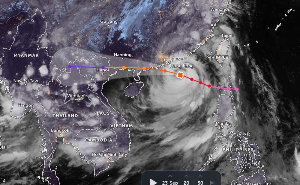
According to the new weather forecast from the National Center for Hydro-Meteorological Forecasting, today, September 24, super typhoon Ragasa will officially make landfall in Guangdong province, China.
As of 4:00 a.m. on September 24, the center of the super typhoon was at about 21.1 degrees North latitude - 114.5 degrees East longitude, in the northern sea area of the North East Sea, about 450km east of the Lusian Peninsula (China). The strongest wind near the storm center is level 16-17, gusting over level 17.
The storm is moving west-northwest at a speed of 20 - 25 km/h. Natural disaster risk level: level 4 in the northern sea area of the North East Sea.
By 7:00 p.m. on September 24, the super typhoon moved in a West-Northwest direction at a speed of about 20-25km/h and gradually weakened. The center of the storm is located at about 21.7 degrees North latitude - 111.3 degrees East longitude, on the mainland along the coast of Guangdong province (China); about 350km east of Mong Cai ( guangning).
The strongest wind near the storm center is level 13, gusting to level 16. Natural disaster risk level: level 4 for the northern sea area of the North East Sea; level 3 for the east of the North of the Gulf of Tonkin.
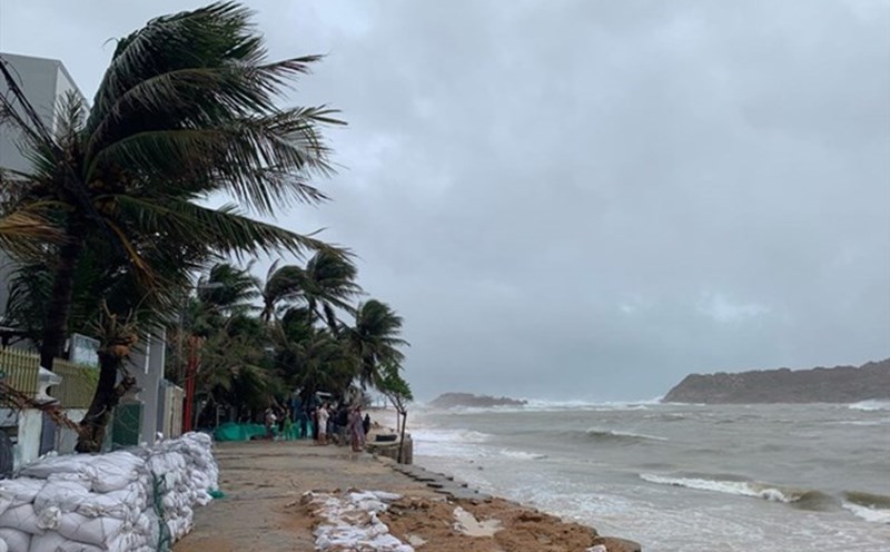
Due to the influence of the super typhoon, the sea area north of the North East Sea will have strong winds of level 1013, near the center of the super typhoon will have winds of level 1416, gusts above level 17, waves above 10m high, and rough seas.
From September 24, the eastern sea area of the Northern Gulf of Tonkin (including the Bach Long Vy special zone) will have winds gradually increasing to level 6-7, gusting to level 9. From the evening and night of September 24, the North of the Gulf of Tonkin (including the special areas of Bach Long Vy, Van Don, Co To, Cat Hai and Hon Dau island) will gradually increase to level 8, with waves 2.0-4.0m high, near the storm's eye level 9-10, gusts of level 12, waves 3.0-5.0m high; very rough seas.
Quang Ninh-Hai coastal area The storm's rising water is 0.4-0.6 m high. There is a high risk of landslides, sea embankments, and destruction of aquaculture areas, ships, and boats anchored along the coast due to strong winds, rising sea water, and large waves
On land, from early morning of September 25, the coastal areas of Quang Ninh - Ninh Binh will gradually increase to level 6-7, near the storm center level 8-9, gust level1; deep in the Northeast of the mainland, strong winds of level 5, some places level 6, gust level 7-8.
From the night of September 24 to the end of the night of September 26, in the Northern region, Thanh Hoa and Nghe An, there will be heavy to very heavy rain with common rainfall of 100-250mm, locally over 400mm. Beware of heavy rain causing urban flooding.
During and before the storm makes landfall, it is necessary to be on guard against the risk of thunderstorms, tornadoes, and strong gusts of wind.
People and tourists planning to visit these areas should pay attention to weather forecasts. Check flight schedules and follow local instructions to avoid dangerous storms.
Weather forecast for today, September 24:
Hanoi City
Lowest temperature: 25-27 degrees Celsius.
Highest temperature: 33-35 degrees Celsius.
Cloudy, scattered showers and thunderstorms at night, sunny during the day.North to northwest wind level 2-3.
Northwest
Lowest temperature: 23-26 degrees Celsius, some places below 22 degrees Celsius.
Highest temperature: 32-35 degrees Celsius.
Cloudy, scattered showers and thunderstorms at night, locally heavy rain, sunny during the day.Light wind.During thunderstorms, there is a possibility of tornadoes, lightning and strong gusts of wind.
Northeast
Lowest temperature: 24-27 degrees Celsius, mountainous areas below 24 degrees Celsius.
Highest temperature: 32-35 degrees Celsius.
Cloudy, scattered showers and thunderstorms at night, sunny during the day.North to northwest wind level 2-3.During thunderstorms, there is a possibility of tornadoes, lightning and strong gusts of wind.
Thanh Hoa to Hue
Lowest temperature: 24-27 degrees Celsius.
Highest temperature: 31-34 degrees Celsius.
Cloudy, scattered showers and thunderstorms at night, locally heavy rain; showers and thunderstorms in some places during the day.North to northwest wind level 2-3.During thunderstorms, there is a possibility of tornadoes, lightning, hail and strong gusts of wind.
South Central Coast
Lowest temperature: 24-27 degrees Celsius.
Highest temperature: 31-34 degrees Celsius, some places above 34 degrees Celsius.
Cloudy, scattered showers and thunderstorms; scattered showers and thunderstorms at night in the North, locally heavy rain.West to southwest wind level 2-3.During thunderstorms, there is a possibility of tornadoes, lightning, hail and strong gusts of wind.
Central Highlands
Lowest temperature: 19-22 degrees Celsius.
Highest temperature: 25-28 degrees Celsius.
Cloudy, rain, moderate rain and scattered thunderstorms, locally heavy to very heavy rain.Southwest wind level 2-3.During thunderstorms, there is a possibility of tornadoes, lightning, hail and strong gusts of wind.
Southern region
Lowest temperature: 23-26 degrees Celsius.
Highest temperature: 30-33 degrees Celsius.
Cloudy, the West has scattered showers and thunderstorms, especially in the late afternoon and evening there are scattered showers and thunderstorms, locally heavy rain; the East has rain, moderate rain and scattered thunderstorms, locally heavy to very heavy rain (rain concentrated in the late afternoon and night).Southwest wind level 3.During thunderstorms, there is a possibility of tornadoes, lightning, hail and strong gusts of wind.
Ho Chi Minh City
Lowest temperature: 24-26 degrees Celsius.
Highest temperature: 31-33 degrees Celsius.
Cloudy, rain, moderate rain and scattered thunderstorms, locally heavy rain (rain concentrated in the late afternoon and night).Southwest wind level 3.During thunderstorms, there is a possibility of tornadoes, lightning, hail and strong gusts of wind.