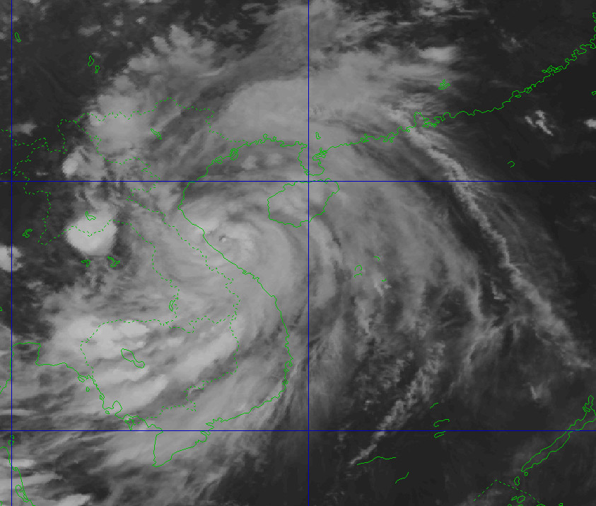
According to the latest weather forecast from the National Center for Hydro-Meteorological Forecasting, on the evening of September 28, storm No. 10 Bualoi in the coastal area of Nghe An - north of Quang Tri province.
The strongest wind near the center of the storm is level 12 (118-133km/h), gusting to level 15.
Storm No. 10 continues to move in the West Northwest direction, at a speed of 20-25km/h.
On the mainland along the coast of the provinces from Quang Ninh to Bac Quang Tri, there were strong winds of level 6-8, gusting to level 9-10.
It is forecasted that by 7:00 a.m. on September 29, storm No. 10 Bualoi will make landfall in Nghe An - Ha Tinh provinces, with an intensity of level 8-9, gusting to level 11.
The natural disaster risk level is level 4 for coastal mainland areas from Nghe An to Ha Tinh; and level 3 for coastal areas from Thanh Hoa to Quang Tri (including Hon Ngu island, Con Co special area); the Gulf of Tonkin (including Bach Long Vi special area, Van Don, Co To, Cat Hai and Hon Dau island).
By 7:00 p.m. on September 29, the storm gradually weakened into a tropical depression in the Upper Laos area. The wind speed drops below level 6.
Coastal areas and islands from Hung Yen - Ha Tinh will have storm surge of 0.5-1.5m high, especially Thanh Hoa and Nghe An will be 1.0-1.5m high. High risk of flooding on the morning of September 29 in low-lying areas, coastal roads, and riverbanks due to rising sea levels, waves and storms.
The area from Thanh Hoa to North Quang Tri has strong winds of level 7-9, the area near the storm's eye has level 10-12 (the wind can knock down trees, houses, electric poles, causing very heavy damage), gusting to level 14. The coastal areas from Quang Ninh to Ninh Binh will have strong winds of level 6-7, gusting to level 8-9, some places will have level 8, gusting to level 10.
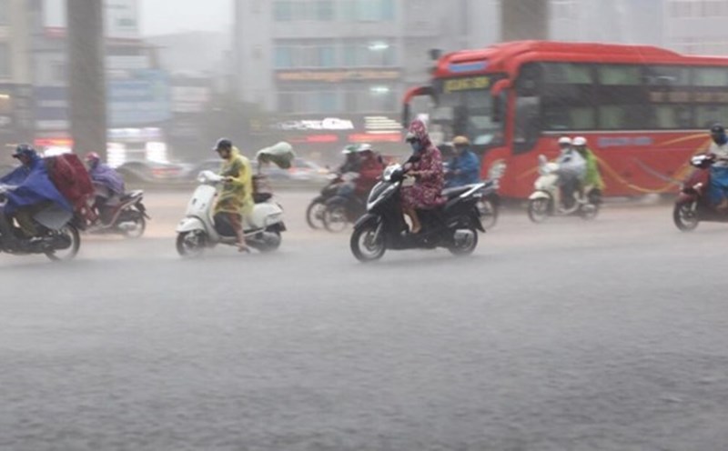
From the night of September 28 to the morning of September 29, the area from South Quang Tri to Da Nang will have moderate to heavy rain with total rainfall from 40-80mm, locally over 150mm.
From the night of September 28-30, the Northern Delta, Phu Tho, the southern provinces of Son La, Lao Cai and the provinces from Thanh Hoa to the north of Quang Tri will have heavy to very heavy rain with total rainfall ranging from 200-350mm, locally over 500mm.
Warning of the risk of heavy rain (>200mm/3 hours). Other places in the North will have moderate rain, heavy rain, some places will have very heavy rain with total rainfall ranging from 100-250mm, locally over 400mm.
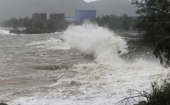
The weather at sea and in coastal areas during the storm is extremely dangerous and unsafe for any vehicles or works operating in the dangerous area such as: Tourist boats, passenger ships, transport ships, cages, rafts, aquaculture areas, dykes, embankments, coastal roads. Vehicles are likely to overturn or be destroyed; flooded due to strong winds, large waves and rising sea levels.
Weather forecast for tomorrow, September 29 nationwide:
Hanoi Lowest temperature: 23-25 degrees Celsius Highest temperature: 30-32 degrees Celsius Cloudy weather, moderate rain, heavy rain and thunderstorms, locally very heavy rain.
Northeast wind level 3.
Northwest Lowest temperature: 21-24 degrees Celsius, some places below 20 degrees Celsius Highest temperature: 25-28 degrees Celsius Cloudy weather, moderate rain, heavy rain and scattered thunderstorms, locally very heavy rain.
Light wind.
Northeast Lowest temperature: 22-25 degrees Celsius, mountainous areas below 21 degrees Celsius Highest temperature: 25-28 degrees Celsius Cloudy weather, moderate rain, heavy rain and scattered thunderstorms, locally very heavy rain; plain areas have heavy to very heavy rain.
Northeast wind level 3, especially along the coast from Quang Ninh to Ninh Binh, strong wind level 6-7, gust level 8-9.
Thanh Hoa to Hue Lowest temperature: 22-25 degrees Celsius Highest temperature: 26-29 degrees Celsius, some places above 29 degrees Celsius
Cloudy weather, heavy to very heavy rain and thunderstorms, from tomorrow the rain will gradually decrease in the South. The area from Thanh Hoa to North Quang Tri will have strong winds of level 6-7, then increase to level 8-9, the area near the storm's eye will have winds of level 10-12, gusting to level 14.
From South Quang Tri to Hue City, strong winds of level 6-7, gusting to level 8-9; tomorrow the wind will gradually decrease.
South Central Coast Lowest temperature: 23-26 degrees Celsius Highest temperature: 29-32 degrees Celsius, some places above 32 degrees Celsius Cloudy weather, in the North there are showers and scattered thunderstorms, some places have heavy rain; Da Nang has moderate rain, heavy rain at night, some places have very heavy rain.
In the South, there will be showers and thunderstorms in some places.Southwest to southwest wind level 3-4.
Central Highlands Lowest temperature: 19-22 degrees Celsius Highest temperature: 26-29 degrees Celsius Cloudy weather, scattered showers and thunderstorms, locally heavy rain.
Southwest wind level 2-3.
Southern region Lowest temperature: 23-26 degrees Celsius Highest temperature: 29-32 degrees Celsius Cloudy weather, scattered showers and thunderstorms, locally heavy rain.
Southwest wind level 2-3.
Ho Chi Minh City Lowest temperature: 24-26 degrees Celsius Highest temperature: 30-32 degrees Celsius Cloudy weather, scattered showers and thunderstorms, locally heavy rain.
Southwest wind level 2-3.