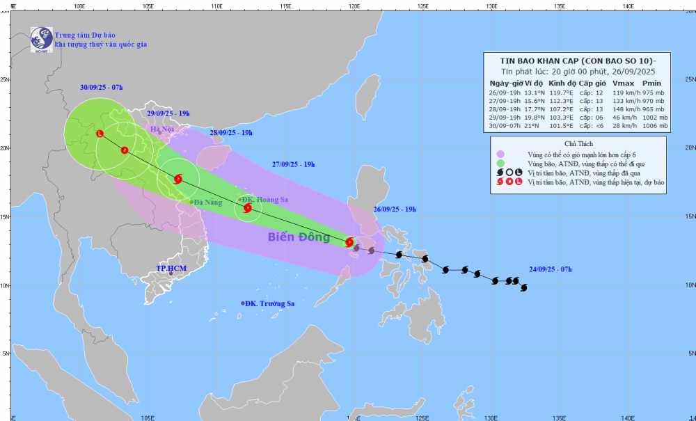
According to the National Center for Hydro-Meteorological Forecasting, on the morning of September 27, storm No. 10 Bualoi officially entered the East Sea.
As of 7:00 a.m. on September 27, storm Bualoi was moving in a West-Northwest direction at a speed of 30-35 km/h, entering the East Sea and tending to strengthen. The center of the storm is located at about 14.5 degrees North latitude - 116.6 degrees East longitude.
The strongest wind near the storm center is level 11-12, gusting to level 15. Natural disaster risk level: level 3 for the Northeast and Central East Sea.
Due to the influence of storm No. 10, the North & Central East Sea (including Hoang Sa) will have strong winds of level 813, gusts of level 16, waves 610 m high, and rough seas. Outside Thanh Hoa - Quang Ngai and the Gulf of Tonkin, there will be gradually strong winds of level 813, gusts of level 16, waves 37 m high, and very rough seas.
The coastal area of the North Central region will have water level rise 11.5 m, with the risk of flooding low-lying areas, landslides, and destruction of aquaculture.
On land, on the morning of September 27, in the Northeast region, Phu Tho and Thanh Hoa, there will be moderate rain, heavy rain and thunderstorms, with common rainfall of 3060mm, locally very heavy rain over 120mm. From the afternoon of September 27, heavy rain will gradually decrease. Warning of the risk of heavy rain (>100mm/3 hours).
The Northwest region, from Nghe An to Lam Dong and the South, will have scattered showers and thunderstorms, with common rainfall of 2040mm, locally heavy to very heavy rain over 100mm. Warning of the risk of heavy rain (100mm/3 hours).
From the afternoon of September 28, Thanh Hoa - Bac Quang Tri will have winds of level 8'12, gusts of 14, Quang Ninh - Ninh Binh, Nam Quang Tri - Hue will have winds of level 6'7, gusts of 8'9.
From September 28 to 30, the North and Thanh Hoa - Hue will have rain of 100300 mm, some places over 400 mm; in the Northern Delta, Thanh Hoa - Ha Tinh will have rain of 200400 mm, some places over 600 mm.
People and tourists to these areas should pay attention to weather forecasts. Avoid going out during heavy thunderstorms and follow local instructions to ensure safety throughout the journey.
Weather forecast for today, September 27 nationwide:
Hanoi
Lowest temperature: 23-25 degrees Celsius Highest temperature: 27-29 degrees Celsius Cloudy, moderate rain, heavy rain and thunderstorms at night and in the morning, locally very heavy rain, gradually decreasing after the rain.
Winter wind level 2-3.During thunderstorms, there is a possibility of tornadoes, lightning and strong gusts of wind.
Northwest
Lowest temperature: 21-24 degrees Celsius, some places below 20 degrees Celsius Highest temperature: 25-28 degrees Celsius, some places above 28 degrees Celsius Cloudy, scattered showers and thunderstorms, locally heavy rain, especially in South Phu Tho tonight to tomorrow morning there will be moderate rain, heavy rain and thunderstorms, locally very heavy rain.
Light wind.During thunderstorms, there is a possibility of tornadoes, lightning and strong gusts of wind.
Northeast
Lowest temperature: 22-25 degrees Celsius Highest temperature: 26-29 degrees Celsius, some places above 29 degrees Celsius Cloudy, moderate rain, heavy rain and scattered thunderstorms at night and morning, locally very heavy rain, gradually decreasing after the rain.
Winter wind level 2-3.During thunderstorms, there is a possibility of tornadoes, lightning and strong gusts of wind.
Thanh Hoa to Hue
Lowest temperature: 22-25 degrees Celsius Highest temperature: 26-29 degrees Celsius Cloudy, scattered showers and thunderstorms, locally heavy to very heavy rain.
Light wind.During thunderstorms, there is a possibility of tornadoes, lightning, hail and strong gusts of wind.
South Central Coast
Lowest temperature: 24-27 degrees Celsius Highest temperature: 29-32 degrees Celsius, some places above 32 degrees Celsius Cloudy, scattered showers and thunderstorms, scattered showers and thunderstorms tonight and tomorrow afternoon, locally heavy rain.
West to southwest wind level 2-3.During thunderstorms, there is a possibility of tornadoes, lightning, hail and strong gusts of wind.
Central Highlands
Lowest temperature: 19-22 degrees Celsius Highest temperature: 25-28 degrees Celsius, some places above 28 degrees Celsius Cloudy, scattered showers and thunderstorms, locally heavy to very heavy rain.
Southwest wind level 2-3.During thunderstorms, there is a possibility of tornadoes, lightning, hail and strong gusts of wind.
Southern region
Lowest temperature: 24-27 degrees Celsius Highest temperature: 28-31 degrees Celsius Cloudy, scattered showers and thunderstorms, scattered showers and thunderstorms tonight and tomorrow afternoon, locally heavy rain.
Southwest wind level 2-3.During thunderstorms, there is a possibility of tornadoes, lightning, hail and strong gusts of wind.
Ho Chi Minh City
Lowest temperature: 23-25 degrees Celsius Highest temperature: 29-31 degrees Celsius Cloudy, scattered showers and thunderstorms, scattered showers and thunderstorms tonight and tomorrow afternoon, locally heavy rain.
Southwest wind level 2-3.During thunderstorms, there is a possibility of tornadoes, lightning, hail and strong gusts of wind.


