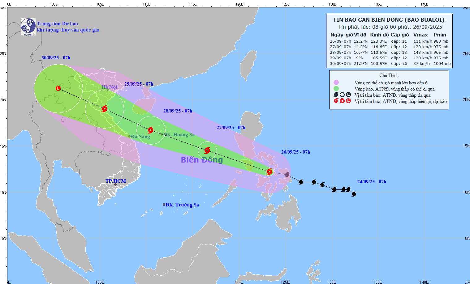
According to the National Center for Hydro-Meteorological Forecasting, storm No. 10 Bualoi is moving rapidly and strengthening in the East Sea.
At 7:00 a.m. on September 28, storm Bualoi moved in a West-Northwest direction at a speed of about 30km/h, likely to strengthen. The center of the storm is located at about 16.9 degrees North latitude - 109.3 degrees East longitude, in the waters of Quang Tri - Hue City, about 200km east of Quang Tri.
The strongest wind near the storm center is level 12-13, gusting to level 16. Natural disaster risk level: Level 3 for the North and Central East Sea (including Hoang Sa special zone); sea area from Ha Tinh to Quang Ngai.
At 7:00 p.m. on September 28, the storm moved in a West-Northwest direction at a speed of about 30km/h. The center of the storm is located at about 18.1 degrees North latitude - 106.9 degrees East longitude, in the coastal waters of Nghe An - Quang Tri.
The strongest wind near the storm center is level 12-13, gusting to level 16. Natural disaster risk level: Level 4 for coastal mainland areas from Nghe An to the North of Quang Tri; Level 3 for the western sea area of the North and Central East Sea (including Hoang Sa special zone); the sea area from Ha Tinh to Quang Ngai.
Storm No. 10 is expected to move inland in the Central region on the evening of September 28.
Due to the influence of the storm, the sea area west of the North and Central East Sea (including Hoang Sa special zone) will have strong winds of level 8-9, the area near the storm's eye will have winds of level 10-13, gusts of level 16, waves from 6.0-80.000m high, the area near the storm's eye will have winds of 8.0-10.0m, the sea will be very rough.
The sea area from Thanh Hoa to Quang Ngai (including Hon Ngu island, Con Co and Ly Son special areas) will have strong winds of level 8-9, near the center of the storm will have winds of level 10-13, gusts of level 16, waves from 5.0-4.0m high, rough seas (extremely large destructive power, extremely strong waves). Sinking a ship with a large weight).
From early morning on September 28, the North of the Gulf of Tonkin (including Bach Long Vy, Van Don, Co To, Cat Hai and Hon Dau island) will gradually increase to level 6-7, then increase to level 8-9 (very rough seas, very dangerous for ships), gust level 11, waves from 3.0-5.0m high, very rough seas.
Coastal areas and islands from Ninh Binh - Ha Tinh will have storm surge of 0.5-1.5m high, while from South Thanh Hoa to North Ha Tinh it will be 1.0-1.5m high. The risk of flooding of dykes, coastal roads, and riverbanks due to rising sea levels and waves during the storm is very high in the evening and night of September 28.
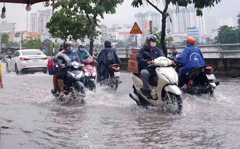
The weather at sea and in coastal areas during the storm is extremely dangerous and unsafe for any vehicles or works operating in the dangerous area such as: Tourist boats, passenger ships, transport ships, cages, rafts, aquaculture areas, dykes, embankments, coastal roads. Vehicles are likely to overturn or be destroyed; flooded due to strong winds, large waves and rising sea levels.
On land, from the afternoon of September 28, on land in the area from Thanh Hoa to Bac Quang Tri, the wind will gradually increase to level 6-7, then increase to level 8-9, the area near the storm's eye will pass level 10-12 (the wind can cause trees, houses, electric poles to fall, causing very heavy damage), gust level 14. coastal areas from Quang Ninh to Ninh Binh, from South Quang Tri to Hue City. The wind will gradually increase to level 6-7 ( Trees will move, difficult to go back to the wind), gust level 8-9. The level of impact according to the wind level of the storm is detailed in Appendix 1.
From the evening of September 27, in the North and the area from Thanh Hoa to Quang Ngai, there is a possibility of a widespread heavy rain with total rainfall ranging from 100-300mm, locally over 450mm; in the Northern Delta, South Phu Tho and from Thanh Hoa to the North of Quang Tri, it is likely to be 200-400mm, locally over 600mm. Warning of the risk of heavy rain (>200mm/3 hours).
Weather forecast for today, September 28 nationwide:
City. Hanoi
Lowest temperature: 24-26 degrees Celsius.
Highest temperature: 30-32 degrees Celsius.
Cloudy, scattered showers and thunderstorms; from this afternoon there will be scattered showers and thunderstorms, locally heavy rain.Northeast wind level 2-3.During thunderstorms, there is a possibility of tornadoes, lightning and strong gusts of wind.
Northwest
Lowest temperature: 22-25 degrees Celsius, some places below 22 degrees Celsius.
Highest temperature: 29-32 degrees Celsius, some places above 32 degrees Celsius.
Cloudy, scattered showers and thunderstorms, locally heavy rain.Light wind.During thunderstorms, there is a possibility of tornadoes, lightning and strong gusts of wind.
Northeast
Lowest temperature: 23-26 degrees Celsius.
Highest temperature: 29-32 degrees Celsius, some places above 32 degrees Celsius.
Cloudy, scattered showers and thunderstorms, some places have heavy rain; in the southern plains and coastal areas from this afternoon, there will be moderate rain, heavy rain and scattered thunderstorms, some places have very heavy rain.Northeast wind level 2-3; from this afternoon, coastal areas of Quang Ninh to Ninh Binh will gradually increase to level 6-7, gusting to level 8-9.During thunderstorms, there is a possibility of tornadoes, lightning and strong gusts of wind.
Thanh Hoa to Hue
Lowest temperature: 22-25 degrees Celsius.
Highest temperature: 26-29 degrees Celsius.
Cloudy, with heavy to very heavy rain and thunderstorms.North to northwest wind level 2-3; from this afternoon the wind will gradually increase to level 6-7, especially from Thanh Hoa to North Quang Tri, then increase to level 8-9, near the storm center level 10-12, gust level 14.During thunderstorms, there is a possibility of tornadoes, lightning and strong gusts of wind.
South Central Coast
Lowest temperature: 23-26 degrees Celsius.
Highest temperature: 28-31 degrees Celsius, some places in the South above 31 degrees Celsius.
Cloudy, scattered showers and thunderstorms, locally heavy rain; in the North, there will be heavy to very heavy rain.North strong wind level 4-5, South southwest wind level 3.During thunderstorms, there is a possibility of tornadoes, lightning, hail and strong gusts of wind.
Central Highlands
Lowest temperature: 19-22 degrees Celsius.
Highest temperature: 25-28 degrees Celsius.
Cloudy, scattered showers and thunderstorms, locally heavy rain.Southwest wind level 2-3.During thunderstorms, there is a possibility of tornadoes, lightning, hail and strong gusts of wind.
Southern region
Lowest temperature: 23-26 degrees Celsius.
Highest temperature: 29-32 degrees Celsius.
Cloudy, scattered showers and thunderstorms, locally heavy rain.Southwest wind level 2-3.During thunderstorms, there is a possibility of tornadoes, lightning, hail and strong gusts of wind.
Ho Chi Minh City
Lowest temperature: 24-26 degrees Celsius.
Highest temperature: 30-32 degrees Celsius.
Cloudy, scattered showers and thunderstorms, locally heavy rain.Southwest wind level 2-3.During thunderstorms, there is a possibility of tornadoes, lightning, hail and strong gusts of wind.