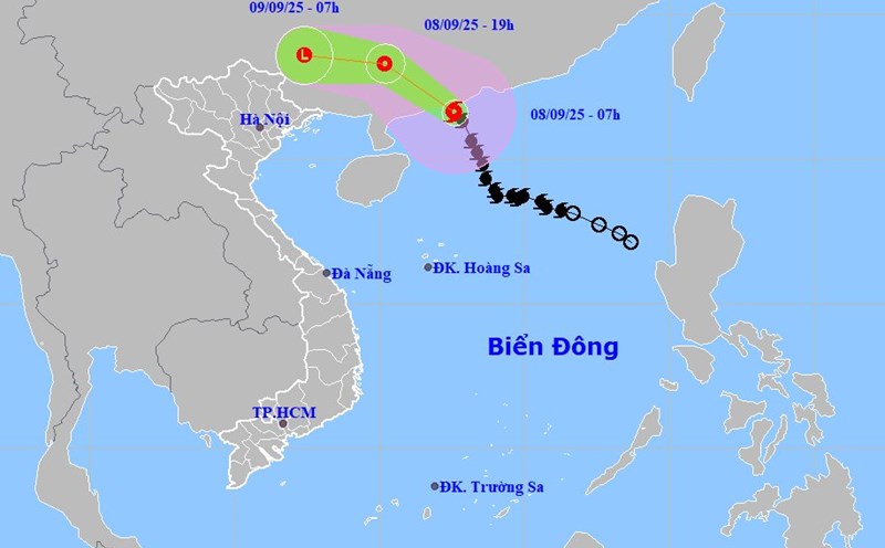
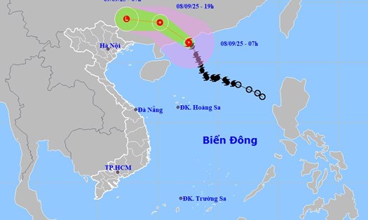
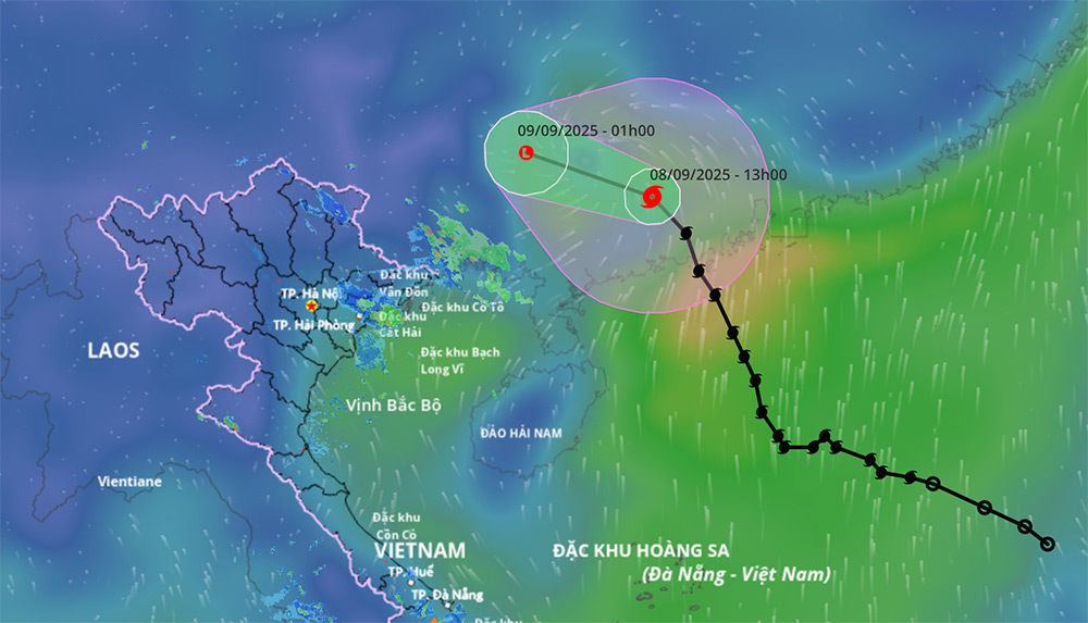
According to the latest storm news from the National Center for Hydro-Meteorological Forecasting, at 4:00 p.m. on September 8, the center of storm No. 7 Tapah was at about 23.2 degrees North latitude; 111.4 degrees East longitude, on the mainland in the Southwest of Guangdong province (China).
The strongest wind near the storm center is level 8 (62-74km/h), gusting to level 10. Moving northwest, speed 20-25km/h.
By dawn on September 9, storm No. 7 Tapah continued to move in the West Northwest direction, 20-25km/h, gradually weakening into a tropical depression and then a low pressure area.
Location is at about 23.8 degrees North latitude - 109.2 degrees East longitude; on the mainland of Guangxi province (China).
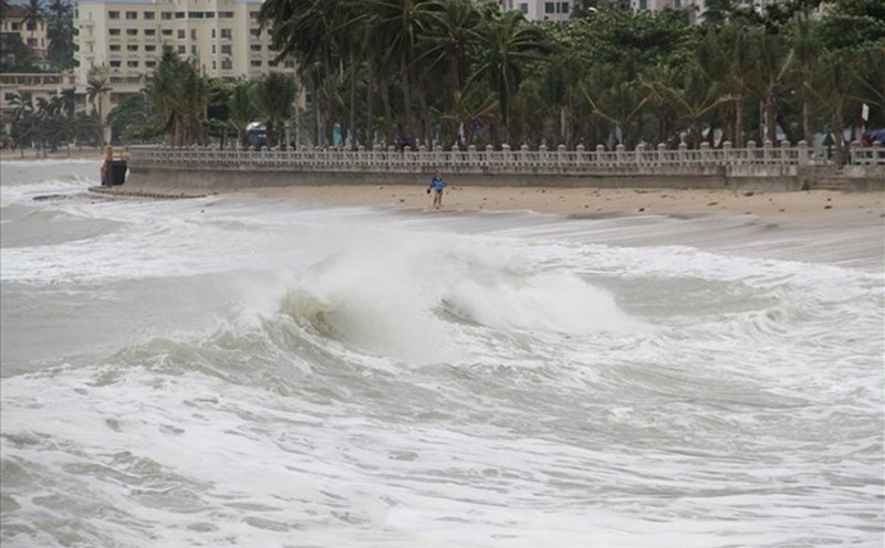
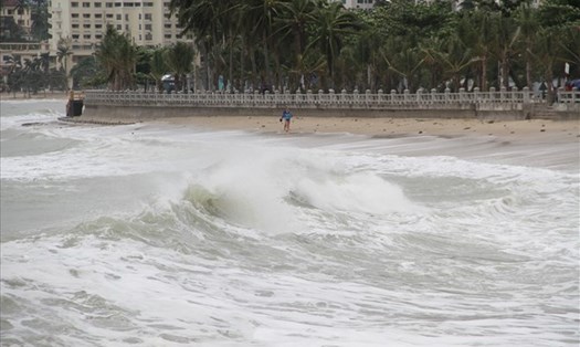
The northwest sea area of the North East Sea will have strong winds of level 6-7, gusts of level 9; waves 2.0-4.0m high, rough seas.
Although not directly affected by the storm's circulation, areas on the far edge of the circulation of storm No. 7 Tapah such as the Gulf of Tonkin, the Northern region and the eastern coastal areas of the North may experience thunderstorms, whirlwinds and strong gusts of wind.
It is forecasted that on the day and night of September 9, in the mountainous and midland areas of the North, there will be moderate rain, heavy rain, locally very heavy rain with common rainfall of 40-90mm, locally over 200mm. Warning of the risk of heavy rain (>100mm/3 hours).
On the day and night of September 10, the mountainous and midland areas of the North will have moderate rain, heavy rain, locally very heavy rain with common rainfall of 30-60mm, locally over 100mm.
Total rainfall from September 9 to the night of September 10, in the mountainous and midland areas of the North, is generally 70-150mm, locally over 300mm).
People and tourists need to pay attention to the fact that heavy rain can cause flooding in low-lying areas, urban areas... with the risk of flash floods and landslides.
Weather forecast for the night of September 8 and tomorrow, September 9:
Hanoi Lowest temperature: 26-28 degrees Celsius Highest temperature: 32-34 degrees Celsius Cloudy, scattered showers and thunderstorms at night, sunny during the day, from tomorrow afternoon there will be scattered showers and thunderstorms.
Light wind.
Northwest Lowest temperature: 24-27 degrees Celsius, some places below 23 degrees Celsius Highest temperature: 32-35 degrees Celsius Cloudy, scattered showers and thunderstorms, from tomorrow afternoon there will be moderate rain, heavy rain and scattered thunderstorms, locally very heavy rain.
Light wind.During thunderstorms, there is a possibility of tornadoes, lightning and strong gusts of wind.
Northeast Lowest temperature: 25-28 degrees Celsius, mountainous areas below 25 degrees Celsius Highest temperature: 31-34 degrees Celsius Cloudy, scattered showers and thunderstorms at night, scattered showers and thunderstorms at night in the Northeast, locally heavy rain; from tomorrow afternoon there will be scattered showers and thunderstorms, locally heavy to very heavy rain, especially in mountainous and midland areas there will be moderate rain, heavy rain and scattered thunderstorms, locally very heavy rain.
Light wind.During thunderstorms, there is a possibility of tornadoes, lightning and strong gusts of wind.
Thanh Hoa to Hue Lowest temperature: 25-28 degrees Celsius Highest temperature: 31-34 degrees Celsius Cloudy, showers and thunderstorms in some places in the evening and at night, sunny during the day.
Southwest wind level 2-3.During thunderstorms, there is a possibility of tornadoes, lightning and strong gusts of wind.
South Central Coast Lowest temperature: 24-27 degrees Celsius Highest temperature: 31-34 degrees Celsius Cloudy, scattered showers and thunderstorms at night, sunny during the day, scattered showers and thunderstorms in the evening.
Southwest wind level 2-3.During thunderstorms, there is a possibility of tornadoes, lightning and strong gusts of wind.
Central Highlands Lowest temperature: 20-23 degrees Celsius Highest temperature: 27-30 degrees Celsius Cloudy, scattered showers and thunderstorms in some places; in the afternoon and evening, there will be scattered showers and thunderstorms, locally heavy rain in some places.
Southwest wind level 2-3.During thunderstorms, there is a possibility of tornadoes, lightning and strong gusts of wind.
Southern region Lowest temperature: 23-26 degrees Celsius Highest temperature: 30-33 degrees Celsius Cloudy, scattered showers and thunderstorms in some places, scattered showers and thunderstorms in the afternoon and evening, locally heavy rain in some places.
Southwest wind level 2-3.During thunderstorms, there is a possibility of tornadoes, lightning and strong gusts of wind.
Ho Chi Minh City Lowest temperature: 24-26 degrees Celsius Highest temperature: 31-33 degrees Celsius Cloudy, scattered showers and thunderstorms in some places, scattered showers and thunderstorms in the afternoon and evening, locally heavy rain in some places.Southwest wind level 2-3.
During thunderstorms, there is a possibility of tornadoes, lightning and strong gusts of wind.