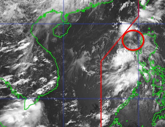
According to the latest weather forecast from the Philippine Atmospheric, Geophysical and Astronomical Services Administration (PAGASA), as of 2:00 p.m. on June 18, the low pressure area has entered the North East Sea.
The center of the low pressure is located at about 16.8 degrees North latitude - 118.9 degrees East longitude, 160km west of Bacnotan, La Union, Philippines.
The low pressure is unlikely to develop into a tropical depression within the next 24 hours.
Due to the influence of the low pressure, Metro Manila, La Union, Pangasinan, Bataan, Zambales, Oriental Mindoro, Western Mindoro, Batangas, Cavite, Surigao del Sur, Davao Oriental, Davao Occidental, Sarangani and Sultan Kudarat areas will have cloudy skies with scattered thunderstorms.
Heavy rain can cause flash floods or landslides.
The low pressure has not yet affected the sea and mainland areas of Vietnam.
According to the National Center for Hydro-Meteorological Forecasting, on the afternoon of June 18, the Northern, Central Highlands and Southern regions will experience showers, with some places experiencing heavy rain.
Some places recorded heavy rainfall including Ninh Thanh Loi (Bac Lieu): 84.8mm, Lam Son (Ninh Thuan): 77.0mm, Thai Ninh Hamlet (Tay Ninh): 68.6mm, Ea So (Dak Lak): 67.8mm.
Forecast of thunderstorms in the evening and night of June 18, the mountainous and midland areas of the North will have scattered showers and thunderstorms, locally heavy rain, common rainfall of 10-30mm, some places over 70mm.
The Central Highlands and the South will have scattered showers and thunderstorms, locally heavy rain, rainfall of 15-40mm, some places over 80mm.
It is forecasted that in the evening and night of June 19, the mountainous and midland areas of the North will have rain, moderate rain and scattered thunderstorms, locally heavy rain to very heavy rain with common rainfall of 20-40mm, some places over 100mm.
Other areas of the North: scattered showers and thunderstorms, locally heavy rain, common rainfall of 10-30mm, some places over 70mm.
People and tourists should be on guard during thunderstorms with the possibility of tornadoes, lightning, hail and strong gusts of wind. Beware of the risk of flash floods, landslides in mountainous areas and flooding in low-lying areas.


